Posts Tagged ‘Trail Ridge Road’

A 5-Day Colorado Ride

Thursday, August 6th, 2026


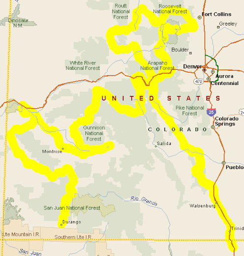
Map for 5-day ride.

I got a comment last week from Richard, referring back to a very old post where I had put together a suggested ride for someone who had found this website:

Hello Ken, I will be part of a 4-bike group coming from Central Texas September 20 and starting our CO tour 21st. This route looks great but would you recommend a slightly different one for us? Our only two wishes would be to 1. ride the MDH from Ouray to Silverton (north to south rather than the other way around) and 2. end up in the very south of CO as we need to head for Ruidoso NM on Day 6 (Saturday 26th).

I could probably adapt this myself but why not ask an expert who knows the state as I could route us right past something magnificent. We are coming from Brownwood TX and are comfortable with 600 miles or so on our ride to CO – so maybe staying that night in the very north of NM.

Of course I’m always happy to help riders plan their trips so using the original post as a starting point I put together this following route to meet Richard’s wishes.

Two points I would make: These days are around 300 miles and while that may not seem like much, on slow-going mountain roads that can actually be a pretty long day. So you should just pick different points to stop for the night and whatever other adjustments suit your needs. Also, this route leaves the group in southwestern Colorado for the fifth day so if they wish to stay west it could be a short day, but if they want to head back east it’s a nice day’s ride of their choice. Heading for Ruidoso the next day I suspect they will want to come back east. Here’s the route:

Arriving
Come from central Texas and stop for the night at either Raton or come into Colorado a bit to Trinidad or Walsenburg.

Day 1
Starting out Day 1, cruise a short distance north on I-25 to the Colorado City/Rye exit (CR 670) into Colorado City and pick up CO 165 west toward San Isabel. Pass through San Isabel and make a stop at Bishop Castle. After you’ve gotten enough of that amazing piece of art continue on 165 to where it hits CO 96 and turn right, heading up to Florence and then take CO 115 on into Canon City. Go west on US 50 just out of town and look for the turn-off to Skyline Drive. Ride Skyline Drive, which takes you right back into town. Then head west on US 50 again, this time looking for CO 9, at Parkdale and take it north to Fairplay. Continue on 9 over Hoosier Pass down to near Frisco and then take a right onto Swan Mountain Road along the east side of Dillon Reservoir. You’ll hit US 6. Take US 6 east over Loveland Pass and down to I-70. A short jaunt on I-70 will bring you to the US 40/Empire exit. Take US 40 through Empire and on up over Berthoud Pass, down to Winter Park. That’s just a hair under 300 miles so Winter Park might be a good place to stop for the night.

Day 2
Continue north and west on US 40 to just past Granby and turn right onto US 34, which runs up past Grand Lake and into Rocky Mountain National Park and over Trail Ridge Road. Be aware that you need to arrange your entrance into and through RMNP in advance. Trail Ridge Road brings you out at Estes Park. Continue on US 34 down the Big Thompson Canyon but before you get into Loveland make a left turn on CO 56 up toward Masonville. Take CR 27 (Buckhorn Road) to the left and stay on it (just stay on the pavement) up to Stove Prairie and down the other side where you’ll pick up CO 14 up Poudre Canyon. Take a left on CO 14, up and over Cameron Pass into North Park and Walden. At Walden go left and where the road splits, CO 14 and CO 125, stay to the right on CO 14 down to Muddy Pass, which is US 40. Go west (right) on 40 over Rabbit Ears Pass, down to Steamboat Springs. Unless you want to see Steamboat you will turn at the bottom of the pass onto CO 131/CR 14F and take that road down to Oak Creek, to Yampa, and on to Toponas where you will take a left onto CO134 over Gore Pass and will rejoin US 40 just outside of Kremmling. Take 40 into Kremmling and at just under 300 miles Kremmling would be a good place to spend the night.

Day 3
Head south out of Kremmling on CO 9 (right at the stoplight) on down to Silverthorne. When you reach I-70 get on it and blast west a short distance over Vail Pass, past Vail, to Minturn and turn off onto US 24 over Tennessee Pass. This will bring you to Leadville. Continue south to the Twin Lakes turn-off (CO 82) which will take you over Independence Pass. Go through Aspen down to Carbondale and turn south (left) onto CO 133 over McClure Pass. At Hotchkiss turn south on CO 92 through Crawford down along the north rim of the Black Canyon of the Gunnison until you get to the dam, where you reach US 50. Take 50 on into Gunnison for the night. Total mileage for the day about 315 miles.

Day 4
For Day 4 you’ll start with a little backtracking along the Blue Mesa Reservoir, but soon you’ll reach the dam again and now you keep going on US 50 to Montrose. A terrific sidetrip, if you don’t mind about 20 extra miles, is to turn into the Black Canyon of the Gunnison National Park and ask at the gate about how to find the East Portal Road. This very steep road twists its way all the way to the bottom of the canyon. It’s a great ride. Then you’ll come back up the way you came, all the way back to US 50. Then continue on into Montrose. Head northwest (right) on US 50 through Delta and on to Grand Junction. Follow 50 all the way until it hits I-70 and then take I-70 west a few miles to Fruita. Get off at Fruita and take the well-marked CO 340 down into Colorado National Monument and follow Rim Rock Road through the monument. This will ultimately bring you right back into Grand Junction where you will pick up US 50 and head back the way you came in, but only for about 8 miles. At Whitewater turn right onto CO 141, the Unaweep Tabeguache Scenic Byway through Gateway and on down to Naturita. Past Naturita, where CO 145 splits off from CO 141 take CO 145 to Placerville. At Placerville go left onto CO 62 to Ridgway. Another 10 miles south on US 550 puts you in Ouray for the night. Total about 310 miles.

Day 5
This last day has you headed onto the Million Dollar Highway. You climb up into the canyon from Ouray and wind your way south to Silverton over Red Mountain Pass. From Silverton you continue south over Molas Pass down to Durango. That’s just over 60 miles. From here you have a number of options and I’ll leave it to you to decide what works best. You could head east out of Durango on US 160 to Pagosa Springs and then go over Wolf Creek Pass and down to South Fork. From there you would continue east on 160 to Alamosa and then maybe turn south to set up for your next day’s ride to Ruidoso. Or at Pagosa you could turn south on US 84 down into New Mexico and turn south at Chama toward Espanola. Or at Chama you could come back into Colorado on NM 17/CO 17 over Cumbres and La Manga Passes to Antonito. Then turn south on US 285 into New Mexico. Or from Durango you could continue south on US 550 to Aztec and wherever in New Mexico you want to make it to that day.

So, OK. Tweak away. I guarantee this route would be pretty darn sweet but everyone is different. Take from it as you wish. Have a great ride.

Biker Quote for Today

It truly is an odd thing we bikers do, riding through miserable conditions like this. We don’t invite then or look for them, surely, but when they are upon us we relish the challenge and silently claim the superiority of adventure over comfort, wilderness over warmth, discovery over certainty. — Foster Kinn
Route For A Five-Night Colorado Ride

Monday, March 18th, 2024

It’s pretty dang hard to beat motorcycle riding in Colorado.

Over the years I have received numerous requests from folks coming to Colorado to ride, asking me for recommendations on a route. I’m always happy to oblige and each one is different, with different parameters of what they want, how long they have . . . that kind of stuff.

The most recent is from Kevin in Indiana. He said he and a buddy have ridden many of the unpaved passes throughout the state by now they want to come on street bikes with their wives and do the pavement. Rather than the hub and spoke riding they have done out of Frisco and Crested Butte, Kevin asked for “an epic continuous trip” for his buddy’s 60th birthday.

Here’s what I sent him.

OK Kevin, I have something mapped out. A couple days are a bit over 250 but under 300. Obviously you can make any changes you see fit.

Figuring on you starting in Denver you can go north to Loveland, up the Big Thompson Canyon to Estes Park, over Trail Ridge Road to Granby and then take US 40 on to Kremmling for the night. This is shorter than 250 but with Trail Ridge Road you’ll definitely want to be making stops. You will need to make a reservation to get into Rocky Mountain National Park. The less busy entrance is the Fall River Road entrance. Park entrance differs if you want to see the park or just go through. I believe they allow people passing through in without reservations both early and late. You’ll see plenty of the park just going through. If you don’t make a reservation you might want to spend the night in Estes so you’ll be right there to go through early. That’s what my wife and I did last year.

(As an alternative to Loveland and the Big Thompson you could go up any number of passes to the Peak-to-Peak Highway and take it north to Estes.)

From Kremmling take US 40 west a bit further and turn onto CO 134 over Gore Pass. At Toponas go south to Wolcott and I-70, then east to the Minturn exit and take Tennessee Pass to Leadville, then a bit further south to Twin Lakes and go over Independence Pass through Aspen and down to Carbondale. From Carbondale take CO 133 over McClure Pass down to Hotchkiss for the night.

From Hotchkiss go west on CO 133 to CO 65 through Cedaredge and over the Grand Mesa. When the road forks north of Mesa stay on 65 (left fork) on to I-70. Take I-70 to Fruita then take the road south through Colorado National Monument, on Rim Rock Drive. Exiting the south end of the monument find your way to US 50 south and go maybe 8 miles to Whitewater. Take CO 141 west toward Gateway, then south to Telluride. This is the Unaweep Tabeguache Scenic Byway. Spend the night in Telluride.

From Telluride go over Lizard Head Pass down to Cortez, US 160 east to Durango, then US 550 north over Red Mountain Pass (the Million Dollar Highway) to Montrose, then east on US 50 to Gunnison. Overnight in Gunnison.

From Gunnison, run back a few miles to the Blue Mesa Reservoir and turn south on CO 149 through Lake City over Slumgullion Pass, through Creede and down to South Fork. Take US 160 west over Wolf Creek Pass to Pagosa Springs, then turn south on US 84 down into New Mexico to Chama. Go northeast from Chama over Cumbres and La Manga Passes on CO 17 up to Antonito, then US 285 north to Alamosa. Spend the night in Alamosa.

From Alamosa you have several options to get back to Denver. You can just take CO 17 north to pick up US 285 and follow that all the way to Denver. Or you can take US 160 east over La Veta Pass to Walsenburg, then go right back west and north out of Walsenburg on CO 69 to Westcliffe, then east on CO 96 on to Pueblo or up to Florence, to Penrose, and on to Colorado Springs.Or make your way to Canon City and then, because you guys are comfortable on gravel, take Phantom Canyon Road (CR 67) up to Cripple Creek, CR 61 up to Divide, pick up US 24, and take that to Woodland Park. At Woodland Park you can either continue on US 24 to Colorado Springs or go north on CO 67 through Deckers to Pine to US 285 southwest of Conifer. Then take 285 on into Denver.

This would be a heck of a good ride. Pick and choose what you like.

Besides being a nice guy and mapping this out for Kevin and his crew, I’ve done myself a favor here. First off, I got this blog post out of it. At this time of year it is harder than during the summer to keep coming up with blog ideas. But I may make it a triple. I figure this might well be a good basis for planning the 2025 OFMC trip. The 2024 trip is already planned but I might incorporate a lot of this for 2025. Also, I’ve been thinking for a long time about putting a ride together for the RMMRC. This might also go a long way toward that plan. We’ll just have to see what develops.

Biker Quote for Today

You might be a Yuppie biker if your only scoot has been a Knucklehead & you don’t even know what that is.

Some Great Riding Still Not Open

Monday, May 25th, 2020
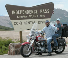
Independence Pass

Don’t go heading for Independence Pass just yet, it’s not open.

The RMMRC was planning a ride over Guanella Pass last week and I was very much inclined to go. But the day was extremely windy and that dampened my enthusiasm. I’ve been out on days when it was windy in town, and when I got to the high country, especially above timber line, it was howling. That’s not my idea of fun, and I ended up not going.

Well, I haven’t had the opportunity to talk to anyone who did go but the next day I read in the Denver Post that Guanella was not open yet. OK. Did they find that out when they got to Grant? Or when they got near the top? Or did they get over despite it being officially closed? I’m curious to find out.

This tied in very conveniently with a post I was already planning, which was to check out the status of all of the larger Colorado roads that close in winter. Here’s what CDOT, the Colorado Department of Transportation, has to say.

Trail Ridge Road through Rocky Mountain National Park is closed for the season and will remain closed until further notice due to ongoing Covid-19 concerns. To hear updated road status please call the Trail Ridge Status Line at 970-586-1222.

Independence Pass. Closed for the season. (OK, does that mean it closed last fall and is not yet open? Are they not going to open it at all this year? I find that doubtful. CDOT could be more helpful here. But the Post article said it will open on June 1.)

Cottonwood Pass. Same. The Denver Post also says this will open on June 1.

Guanella Pass. Same. The Post says to be opened at a date to be determined.

Mount Evans Highway. To be determined.

Pikes Peak. Is expected to be open to the top as of June 1.

So the bottom line here is, check before you go. Don’t count on things opening up at the time they usually do. But I tell you, once it does open I really want to do Cottonwood Pass. They finally got it paved all the way last year and I have not been on it since they were done. This is number one on my list.

Biker Quote for Today

If the countryside seems boring, stop, get off your bike, and go sit in the ditch long enough to appreciate what was here before the asphalt came.

Great Rides: Cross The Continental Divide On Trail Ridge Road

Thursday, July 12th, 2018
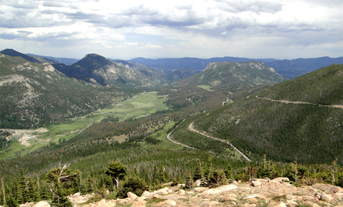
view from Trail Ridge Road

From an overlook on Trail Ridge Road.

You climb through the Big Thompson Canyon heading west out of Loveland with the river crashing down through this jagged granite gorge. Worthy of the ride all by itself, the canyon is just the appetizer as U.S. 34 continues through Estes Park and then the entrée is served: Trail Ridge Road.

Crossing Rocky Mountain National Park over the Continental Divide, Trail Ridge Road is the highest continuous motorway in the United States and a must-do ride for motorcyclists coming to Colorado. Reaching 12,183 feet at its highest point, the road stretches for more than 8 miles above 11,000 feet, well above timberline and offering spectacular views and its own brand of weather.

Warning to bikers: Do not dress for summer on this ride, even if it is blazing hot down lower where you’re starting out from.

You enter the park and loop around West Horseshoe Park, passing throngs of tourists with cameras blazing away at a flock of bighorn sheep. The sky is blue above but the dark, threatening clouds you’ve been eyeing all morning sit ominously to the south. Keep going.

But you can’t ride this road without stopping, so you pull over at several of the many turn-outs, especially Rainbow Curve, where the entire valley and the winding road you’ve just ridden are laid out below you. This is why you brought the camera.

The climb continues and then you’re above timberline, and two things demand your attention. First, the road is torn up for resurfacing, leaving loose sand and gravel in many places and just generally lousy road everywhere else. Second, the wind has picked up, that threatening cloud is now not far away at all, and the temperature has dropped about 20 degrees. Time for extra layers and gloves.

You loop along above timberline, through broad sweepers, up and down tundra-covered hills, and through a narrow notch cut through rock on one particularly steep curve. You’ve now passed the highest point in the road, and coming around a curve you descend a bit to the Alpine Visitor Center. Time to go inside, get warm, and have a bit of lunch.

Sitting in the restaurant at a table by a window you peer down the steep drop below you, watching a marmot scamper across a snowfield that never melts. Clouds the color of a nasty bruise now hang directly overhead and it would be raining except that it’s too cold to rain. Instead, tiny frozen raindrops tinkle against the window and ricochet off the rocks below you.

Forty-five minutes later the valley below you is completely obscured by clouds but overhead the sun is trying to poke through. You head back to the bike and pull out the rain gear because the road is now wet and there are still clouds to be wary of.

Down you ride, around Medicine Bow Curve, and then you parallel a canyon far below for several miles. Just over Milner Pass there is a crowd pulled over and there are elk with huge racks grazing and sparring. Time again for the camera.

From there the route is down, down, and down, and you exit the park. The town of Grand Lake glides by as do Shadow Mountain Lake and Lake Granby. U.S. 34 ends just west of the town of Granby, where it meets U.S. 40. From here its either west to Steamboat Springs or east over Berthoud Pass and back to Denver. East it is.

Biker Quote for Today

I ride because when everything in life is wrong it’s the only thing that’s right.

Independence Pass, Mount Evans Now Open; Loveland Pass Closed

Thursday, May 21st, 2009

Independence PassNote to the world: Colorado is open for the season.

That’s right, with today’s opening of Independence Pass and CO 5 to the top of Mount Evans opening tomorrow, all the seasonal roads are open. Even Trail Ridge Road is open, although the Colorado Department of Transportation (CDOT) reports that it is icy in spots.

One note of interest, however, is that US 6 over Loveland Pass is closed at this time. This is not a seasonal road, but CDOT says it is “closed for emergency road repair until further notice.” Apparently they just closed it yesterday. That’s a good thing for me to know because I was planning to head up over that pass in just a couple days.

Here’s a bit more info from CDOT:

U.S. 6 over Loveland Pass is closed due to a culvert failure, about 1 ½ miles east of the summit. Excess water has washed out the bottom of the culvert. Safety considerations will not allow the road to be open to traffic due to a loss of roadway support over the culvert. All traffic will be detoured though the Eisenhower Tunnel on Interstate 70. Loveland Pass will remain closed until further notice. The Colorado Department of Transportation will send out more information when it becomes available.

Recent from Denver Motorcycle Examiner
Run For The Wall nearing its destination

Biker Quote for Today

If you don’t make it the first time, back up and try again, only faster!!

Three Day Trips From Estes Park

Sunday, July 29th, 2007

I ran across this question on the Delphi motorcycle forum:

Ok, who is a good ride planner? We plan on being at the KOA in Estes Park in a couple of weeks. We have 3 day that we will be riding day trips out of there. Any recommendations? Not looking for a ton of miles, maybe 200-300 per day or less.

Thanks,

J.R.

I posted this reply:

JR–

From Estes Park you will definitely want to take the ride up over Trail Ridge Road. For a 200-mile ride you could go over Trail Ridge, then from Granby to Walden, then take Coloado 14 over Cameron Pass and down through Poudre Canyon to Fort Collins, and then south to Loveland and back up Big Thompson Canyon to Estes Park.

Beyond that you’re a bit limited. Unless you go over Trail Ridge again to go in other directions from Granby you’re faced with going back down to the plains or coming back at night over the same roads you left on.

You can go south out of Estes Park along the Peak to Peak Highway, to where you meet US 6, to Idaho Springs, up Squaw Pass, and to the top of Mount Evans. Then backtrack, more or less, or return over Trail Ridge.

Then for your third day you might consider going over Trail Ridge again, from Granby head to Kremmling and Steamboat Springs, over Rabbit Ears Pass. Then south on Colorado 131 either to Toponas and back over Gore Pass to Kremmling and backtrack. Or, continue south from Toponas to Wolcott and pick up I-70 and take it back over Vail Pass and get off at Silverthorne and take Loveland Pass to regain the interstate on the east side of the tunnel. Then back just east of Idaho Springs to get back on the Peak to Peak. But that runs close to 300 miles and a very long day. It’s tough from Estes Park because you’re really limited on where you can go from there.

Anyway, I hope that helps. You can find out a lot more about these roads on my website, www.motorcyclecolorado.com. Have fun.

I’m always happy to help. Anyone else looking for motorcycling information in Colorado, just write. I need to make note here, however, that because of the spam bastards I had to turn comments off on this blog. So to write, send your email to ken at motorcyclecolorado dot com.