Archive for the ‘Day Rides’ Category

Last Day Ride Before The Four-Day Trip

Monday, September 14th, 2026


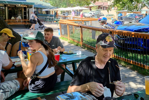
I finally got to try this place in Kittredge when Nick and I stopped there on a Sunday ride.

It was Sunday of Labor Day weekend with Nick and me set to take off on Monday for a four-day ride. Let’s get in one more.

We had already done a ride over Guanella Pass and another over Squaw Pass, and I didn’t want to go out on US 285 because that would be the way we would be heading out the next day. But I pulled up a map and the idea came together.

We headed west across town on Belleview till we came to Santa Fe and as we sat waiting for the turn signal I told Nick this was the exact spot last year on June 29, at about this time on a Sunday morning–like now–that that guy ran head-on into me. Not sure how that made him feel sitting there.

We got onto C-470 briefly, then off at Wadsworth and turned up Deer Creek Canyon Road. We turned south on Deer Creek Road, up that canyon until we climbed out of it. Along the way another rider going the other direction tapped his helmet, which I took to be a warning. I’m accustomed to having someone tap the top of their helmet to indicate cops ahead but this guy tapped the side of his helmet. Nevertheless we slowed down and paid close attention. Sure enough, we came around a bend and there were a whole bunch of folks on those wheeled foot platforms that you use the way you would use cross-country skis on snow. We skirted carefully around them.

We continued to Oehlmann Park Road, which goes steeply up into a mountain community and then steeply down the other side. On the other side we picked up Turkey Creek Road to meet US 285. A short run on that took us into Conifer where we got off and caught Barkley Road to CR 73. Another quick jog and we turned up Shadow Mountain Drive.

This road makes a scenic meander around to the west of Evergreen, coming into Evergreen past some very pricey homes. You pay for all that scenery. In Evergreen I feared we would encounter some street festival blocking our route but I was mistaken. Thankfully. We cruised on through and down to Kittredge.

In Kittredge we stopped for lunch at the place we had stopped recently on an RMMRC ride I led where this was my planned lunch stop. Unlike that ride, this time they were open. Pretty decent food at the Switchback Smokehouse.

Leaving Kittredge we turned up Parmalee Gulch Road over to pick up US 285. And now, after just a short ride, we faced getting home across town on a hot day. But hey! It was Sunday of Labor Day weekend. There was no traffic. It was great. We blasted. It was still hot but hot is not so bad when you’re moving.

Biker Quote for Today

“Tourists and locals are watching from sidewalk cafés. Non-racers. The emptiness of those lives shocks me.” — Tim Krabbé

Never Took This Road This Direction Before

Thursday, September 10th, 2026


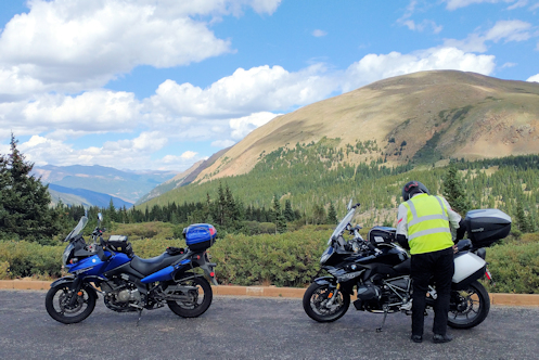
Up at the turn-off from Squaw Pass to go up Mount Blue Sky.

Nick and I headed out for our second ride of his visit, this time on Friday of the Labor Day weekend. No way was I going to take us out I-70.

Again in the cool of the morning we crossed town on Hampden/US 285 and turned north on CO 93 just up to the turn onto CO 46, the road up Golden Gate Canyon. As expected, almost no traffic up here. Yes!

We cruised up to the Peak-to-Peak Highway and turned south on CO 119 to run down to Black Hawk. At Black Hawk we turned up the road to Central City. Through Central City to pick up the Central City Parkway, which we would take over to I-70.

The Central City Parkway was a greenfields road project financed by the casinos with the intention of bringing gamblers more easily to the casinos. It’s up high and it’s two-lane divided highway full of sweepers.

Approaching I-70 we could see the road below and it was choked with traffic leaving the city for an early start on the holiday. Just as I knew it would be. Fortunately, we only needed to get on it for less than two miles and then we got off at Idaho Springs. From the middle of Idaho Springs we crossed the highway and headed up CO 103, up past Echo Lake on the road to Squaw Pass. More nice road and great weather. Who could ask for better?

Just past Echo Lake it was time to make a decision. Nick had some interest in going up to the top of Mount Blue Sky (formerly Mount Evans). The issue was the cost. They have a toll gate at the bottom of the road and even for a motorcycle is would cost $17. Do we both want to ride to the top, just to look around a few minutes and come right back down? Are we $17 dollars interested?

We had been sort of riding with a couple on another bike since Idaho Springs. They must have been thinking the same thing. We all pulled off into this parking lot by the entrance and Nick and I decided no, so we got back on the bikes and took off. A bit later the couple on the other bike passed us going over Squaw Pass. Decision made on both counts. If you want to do Mount Blue Sky, do it in a car where the whole car load goes up for the one price.

So Squaw Pass is a nice ride and it brings you back down to the Evergreen Parkway where we faced another decision. Going left we could get back to I-70 just for a short distance and then get off and take old US 40 back down to CO 93. Or we could go left a very short distance and turn down Kerr Gulch and go through a nice wooded area and end up back at Kittredge. Or, and this is what we did, we could go right into Evergreen but then turn up Little Bear Cub Creek Road up and over to Turkey Creek Road.

I was particularly interested in this because while I have been over this road several times coming to Evergreen, I had never been on it going the other way. This would be a first.

They say a road looks entirely different going the other way and I would say this was not entirely different but it sure was different. It really does give you a different perspective. And through all of this we were successfully avoiding all the early holiday traffic.

You get down to Turkey Creek Road and it quickly brings you to US 285. Not a lot of choice here. So there we were coming back into town in the heat of the day and at rush hour. And once again it was miserable.

Once we got past Broadway and were now on city streets we were on a stretch I have wondered about for a long time. I know that going west on this road I always get in the right-most lane because it moves the fastest from Colorado Boulevard to Broadway. I have often looked at the right-most lane eastbound wondering if it also moved faster. Nick had tried that twice now and didn’t seem to gain anything but I figured OK, let’s try it.

Nope. It was just as slow as the other lanes. So when we got to Colorado, where that lane ends, I turned south on Colorado down to Quincy, which runs sedately through the wealthy Cherry Hills Village area. This is heavily patrolled so you can’t go fast but it’s prettier and there’s a heck of a lot less traffic. And from there we made it on home. Nice day’s ride. We’re toughening Nick up for this upcoming four-day ride. Those easterners think 150 miles is a long day’s ride. That doesn’t cut it out here.

Biker Quote for Today

Get a motorcycle. You will not regret it. If you live. — Mark Twain (sort of)

Nice Day To Ride Guanella

Monday, September 7th, 2026


Nick fishes out another layer on top of Guanella Pass.

Nick is in town with his bike and we’re doing some riding. On Wednesday we rode Guanella Pass.

The great thing about going somewhere and riding with a local is that the local knows all the good roads, most of which you may have no idea exist. So I kicked around several ideas as to what route to take on this ride.

First thing, as always, is getting across town. I live just four blocks off US 285 so 285 is almost always the best way to start off. We headed out to Morrison and then turned up CO 74, up Bear Creek Canyon. At Kittredge we turned up Kerr Gulch in order to avoid the traffic and the busyness of downtown Evergreen. Plus, Kerr Gulch is really a nice ride.

Reaching Evergreen Parkway up by Bergen Park, we jogged just a couple miles over to take the road leading to either westbound I-70 or the overpass across I-70 to get on old US 40 up Mount Vernon Canyon. No surprise, we chose US 40. US 40 is the highway that I-70 replaced and while it wanders away from the slab most of the time, at other times it is basically an I-70 frontage road.

Cruising up through this area I was reminded of what I have seen repeatedly of late, the huge proliferation of dead pine trees. It has all appeared suddenly but it must have been happening for a while. Presumably these trees were fighting pine beetle infestations but with the drought this year they finally lost the battle. A lot of them. This place is a forest fire waiting to happen.

We ran up Floyd Hill alongside I-70 and then down the other side where, at the bottom, you have a great view of the really large highway project now under way to smooth out the sharp turn at the very bottom that has been a thorn in the side of highway planners for decades. At the bottom we turned left, fed onto old US 6, which fed onto I-70, and got off again at Idaho Springs. Time for a break and an explanation for Nick of what he had just seen.

We stayed off the slab, using US 6 to make our way up the canyon, to Georgetown, and then headed up Guanella Pass.

Guanella Pass is big for “leaf-peeping,” cruising the high country in the fall to see the leaves changing color. It gets pretty spectacular in places and this pass is a close-to-town favorite. It’s too early for any leaf-peeping just yet but I did note that just a few aspen were already turning. They say with the drought, though, that this year’s show is likely to be a bit subdued.

I was a bit chilly coming into Georgetown so I put on a sweatshirt while we were there and told Nick what I was doing and why. This is not my first rodeo. Nick figured he’d be fine. We hadn’t gone far up the pass at all when I was feeling very glad to have the extra layer. We stopped at the top and Nick pulled out an extra layer, too.

We cruised down the other side looking to have a bit of lunch in Grant but the food truck that usually sits where the pass road hits US 285 was not there. What was there was a row of A-frame cabins and another row of rectangular cabins with slanted roofs. None of that was there the last time I came this way. Turning toward Denver I pulled into the parking lot of the Shaggy Sheep cafe but as has happened every time I have thought to eat there it was closed. I just always come by on the wrong day of the week. So we rode on to Bailey and had lunch there.

Then it was on down 285 into town and back across town on 285. Right at the peak of the commute, with lots of stop and go and heavy traffic. This was not the 100-degree weather we had recently but we were still roasting. Nick knew where he was going now so he changed lanes to try to make a little better speed but again, not my first rodeo, and we got home with me right behind him.

So it was a short ride for me, a substantial ride for him, and the first step in getting him prepped for the four-day ride we’re doing right after Labor Day.

Biker Quote for Today

“Be at one with the universe. If you can’t do that, at least be at one with your bike.” ~ Lennard Zinn

An Impromptu Ride

Monday, August 24th, 2026


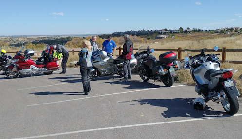
Stopped at Daniels Park with the RMMRC on an earlier ride.

A bunch of the guys from the RMMRC were getting together just for breakfast down in Parker the other day so I figured I’d ride. The forecast was calling for another record hot day but in the morning it would be bearable.

Bob was there. It was good to see him. This was the first time I’ve seen him since I heard he had to give up riding entirely due to health issues. Pretty sad. He said, “It happens in the best of families.”

Dave and Gene were both there and they both rode. They’re getting ready to leave very soon for an Edelweiss Tours ride through the Alps. They wanted to make sure they had their communicators synced up and working properly.

After we ate, and after they got the communicators working, someone said, “So you want to go for a ride?” We were all game.

Gene suggested doing Guanella Pass, which would have gotten us out of the oncoming heat, but Dave didn’t have the time. Other things on his agenda for the afternoon. No, let’s just do a loop down through Salida, to Palmer Lake, and back over to CO 83 and up through Franktown. A ride we’ve all done all or part of a hundred times but what the heck.

I didn’t think about it until we were moving but it would have been a courtesy for me to have texted Judy two words: impromptu ride. But we have our phones set up to track each other so I knew when I didn’t get home when she expected me she would look and see that I was obviously out on a ride. She did.

We headed down to Hess Road and took Hess around the Rueter-Hess Reservoir, across I-25, and onto Castle Pines Parkway. Oh my gosh what a lot of work they’re doing on that road. They appear to be putting in a median the entire way and completely reconstructing the westbound lanes. Slow going.

At Daniels Park we headed south to pick up US 85, then a jog to the right to Salida. Then through Salida to pick up CO 105. This road runs along the face of the foothills and is a favorite for bikers. On summer weekends there’s a constant stream of motorcycles in both directions. On this Friday we had it mostly to ourselves.

The heat was building but as long as we kept moving it didn’t get bad. Other than occasional traffic lights we did not stop.

At Palmer Lake we turned east on Palmer Divide Road. That’s an arrow-straight road that crosses back over I-25 to hit CO 83 coming up from Colorado Springs. To my surprise, Gene turned onto northbound I-25, but I stayed with Dave. I didn’t want to get on the slab. What’s with Gene?

Dave and I cruised on up past Castlewood Canyon State Park, to Franktown, and on to his turn-off at Bayou Gulch Road. Then it was just me cruising on home. A nice ride but by the time I got home I was very pleased to feel the coolness of the swamp cooler at work. And we did set another record high.

Biker Quote for Today

Nothing matters at 90 miles an hour, nothing matters at all.

The Heat Breaks

Thursday, August 20th, 2026


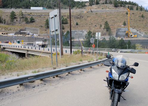
Once completed I-70 at the foot of Floyd Hill will take a flyover through what used to be a hillside in order to smooth out a sharp turn. You can see where the pillars will be built for the westbound lanes. The pillars for the eastbound lanes are already in place.

It has been so blazing hot for so long that I just haven’t been interested in getting out on the bike. Sure, it’s cooler once you get up in the hills but that long slog across town coming home has just been killer. Guess what? It finally cooled off. I went riding.

Heading west across town in the morning was cool and comfortable. I got to Morrison and headed on up Bear Creek Canyon and immediately found myself behind someone in a U-Haul truck. A professional trucker might have pushed that thing around the tight turns at a good clip but this guy was no pro. And there’s almost no place to pass.

This was the slowest trip up the canyon ever. But that wasn’t all bad because the reason things have cooled off is that we have had torrential rains–and we have really needed rain. But with rain comes sand and gravel washing down onto the road. Back in June there were torrential rains up here and this whole road got washed out in several places. This time, however, while there was some sand and gravel, the worst was where unpaved driveways come down to the road. Some were pretty bad but you could see it coming and adjust.

Fortunately I was only going as far as Kittredge. At Kittredge I turned off onto the road up Kerr Gulch. Kerr Gulch Road was much cleaner and there’s never more than minimal traffic so that was great. I got up to Evergreen Parkway and headed north the short distance to where I turned onto old US 40 running up Mount Vernon Canyon and then down the steep decline over Floyd Hill to where US 40 meets US 6.

This is a real point of interest these days. I-70 is right alongside US 40 coming down Floyd Hill and, uncharacteristic of most interstates, at the bottom of the hill you need to slow way down for a sharp left-hand turn into Clear Creek Canyon. Well, it is uncharacteristic of interstates to have such a turn and after all these years they are doing something about it. They have cut off the hilltop and are erecting tall pillars to carry the interstate on a more gently curving arc high above the existing roadbed. It’s a pretty impressive sight. I stopped and shot a couple pictures.

Then I headed down into Clear Creek Canyon to pick up the Peak-to-Peak Highway over toward Black Hawk. So far the sky had been clear and blue but now storm clouds were starting to form. At Black Hawk it looked like it could rain at any time but just a few miles further and the sky was clear again. Weather in Colorado is very localized.

The Peak-to-Peak was clean and clear and up high like this things were very nicely cool. I was planning to head down through Golden Gate Canyon, however, and the last time I was on that road it was lousy with sand and gravel. Odd, because none of the other roads were–just Golden Gate. What would it be like this time?

Clean and clear. Nice. But now the clouds were forming again and looking threatening. It could be a race down the canyon to see if I could get ahead of them. I won the race.

Now south toward Morrison again and then east across town. Yeah, it was a good bit warmer–a bit too warm, I’d say–but nothing like the furnace it has been. Nice to finally get out for a ride.

Biker Quote for Today

You might be a Yuppie biker if you think that’s actually a *suntan* that makes real bikers so dark-skinned.

Pre-Riding Comes Through Again

Monday, June 29th, 2026


It seems the worst of the flooding damage was on the road that is part of my planned route.

I wrote about pre-riding a route you plan to lead a group ride on just a few weeks ago. Well, it seems there’s a very good reason not to do that pre-ride too far in advance. Conditions change.

We just got back from two weeks in Alaska. We flew from Juneau to Seattle and needed to change planes in Seattle. We found right away that our flight was delayed a bit more than an hour. As it turned out, the plane to Denver was coming from Denver and they were delayed more than an hour from taking off. It seems there was a bit of a weather event. We never did learn much about it because it was all over by the time we did get home.

We’ve been home a week now and it occurred to me that if I intend to lead this ride that I’ve been planning since before I got hit head-on exactly one year ago, this is really when I should do it. I was leaning toward posting the ride on the RMMRC site Saturday and meanwhile I was catching up on all the emails that piled up while I was gone.

Surprise, surprise! I came across a new item saying there was extensive flooding in Evergreen and Kittredge, connected to the tornado that shut down the airport. Roads were completely blocked. And my route for this ride goes right through Evergreen and Kittredge. I figured Sunday I’d better take a ride up there and check it out before posting the ride.

So I did. As I headed up Colorado 74 out of Morrison I thought I ought to see a warning sign if the road was closed ahead, and there was no such sign. That’s positive. You go through Idledale before you reach Kittredge and there was a sign just outside of Idledale but I didn’t see it in time to read it, so no help. But that said to be cautious.

I got into Kittredge and the first thing I noticed was that the restaurant I planned to stop at for lunch on this ride seemed to be closed. It is right beside the creek so that was foreboding. I’d have to check on that. Then I got to the west end of Kittredge and where the creek crosses under the road it was obvious what had happened. There was an area to the side where a lot of logs and stumps were piled up, obviously from a clean-up effort, and the bridge abutment still had a lot of the same packed against it. But the road was open, albeit with a good bit of gravel remaining.


It appears they will be reopened in time for us.

On to Evergreen. Everything looked pretty good in Evergreen, though when I reached the fork where one way goes north and the other south, my route being south, I made that turn and it was clear they were not done cleaning up from flooding right there. But it was not bad. On south about a tenth of a mile and you get to the turn-off up Little Cub Creek Road–my route–and then the flooding became extremely evident.

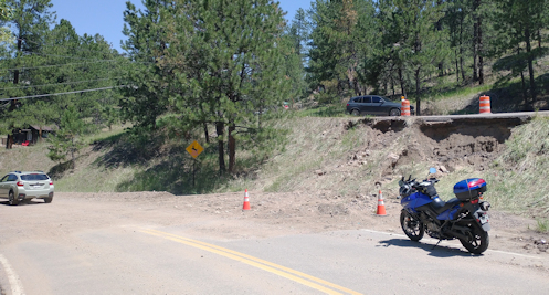
Mostly it was where the stream had come out of its banks and left gravel–a lot of gravel–on the road. Then a little further along I came to a spot where at first I thought the road had been carried away altogether. I turned around and stopped to shoot that picture above. On closer inspection I could see that the adjoining road had been nearly washed away and all that rock and soil was covering the road I was on. It’s all passable but don’t try screaming down this road on a motorcycle. No problem as long as you know what to expect.

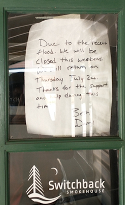
At this point I headed back the way I came and in Kittredge I stopped to check out the restaurant. They had a sign on the door saying that due to the flooding they were closed over the weekend but would reopen right away.

OK, I guess I can lead this ride. Now I just have to get it posted.

Biker Quote for Today

Cause one day you are gonna say that today was bumping. We’re living on the edge and my motorcycle’s speeding. It is what it is and this is how I’m feeling. — Charles Smith