Archive for the ‘New Zealand Rides the Rockies’ Category

No Rockies Ride for New Zealand Crew This Year

Thursday, January 8th, 2009

You may recall that I did a whole series of posts awhile back called “New Zealand Rides the Rockies,” mapping out the routes that a bunch of kiwi riders were planning for this summer.

Well, I got an email from Steve, the organizer, the other day and the trip is off for this year. The current global economic debacle is to blame. Steve still hopes to do the trip, but he says it will be 2010 at the earliest.

I sure know how that goes, having been out of work myself for most of 2008, and only recently getting back to work and putting my finances in good order.

Nevertheless, it was interesting how I came to email Steve last week. It seems that Dirk, a biker who read this blog, is planning a riding trip in New Zealand and had been trying to find out about good roads down there. He tried reaching some motorcycle clubs but got no answer so he contacted me, asking to be put in touch with the guys I knew. I did, and Steve replied with his news.

Oh well. We were looking forward to hosting Steve and his buddies, but we’ll be just as happy to see them in 2010, if that works out.

Biker Quote for Today

When life throws me a curve I will lean into it!

New Zealand Rides The Rockies – Day 10

Friday, March 14th, 2008

Recap: Steve and some buddies are coming from New Zealand in 2009 for some motorcycle touring in Colorado and Utah. This series of posts lays out their proposed routes, with my comments. Your comments are welcome as well.

Day 10

Oh no! This 10-day motorcycle ride around the Rockies is coming to an end. Today is the final day. Dang. Oh well, Steve and the gang are in Golden and need to end up back in pretty much the same place in order to turn in the bikes and head home. Today they’re going to cruise the Peak-to-Peak Highway and check out the canyons leading up and down between this road and the flatlands. They don’t have a detailed route in mind so this can be taken as a possible route. Here’s the map, and the enlarged view.

Peak-to-Peak Highway and adjoining canyons

At day’s end yesterday, our group came down US 6 through Clear Creek Canyon, so we don’t really need to backtrack today. Going north out of Golden on CO 93 it is just a couple miles to the turn-off to CO 46 up Golden Gate Canyon. This is a favorite ride and a great way to start the day. Winding up the canyon, you reach CO 119, which is the southern portion of the Peak-to-Peak. From here we’ll turn north, to the right.

Now, there are any number of ways you could do this ride. I’m going to suggest that they just go all the way to Estes Park in the beginning and then work the canyons on the way back. That means CO 119 as far as Nederland, then CO 72 to where it terminates into CO 7, and then CO 7 to Estes Park. Don’t be surprised coming into Estes Park if you come upon a traffic back-up, there are herds of elk around here that are not shy and everyone stops to look.

From Estes Park we now turn east on US 36. This road goes down the North St. Vrain toward Lyons. At Lyons you just cruise through town and out the other side and you’re back on CO 7, which goes back up the South St. Vrain to where you met it before. At that point it’s time to head south on CO 72, the road you came north on.

Heading south on CO 72 you come (again) to Ward, and the intersection with Lefthand Canyon Drive, or Boulder County Road 94. Go ahead and take this turn. It runs down (surprise!) Lefthand Canyon and comes out to US 36 north of Boulder. Head south toward Boulder but when US 36 jogs to the left, stay straight on CO 7, Broadway. This will be a nicer ride through town.

Broadway leads you right into the middle of Boulder, where you take a right on either Walnut or Canyon and on out of town directly into Boulder Canyon on CO 119. There are a number of places to stop on your way up this canyon, and one of the best is Boulder Falls.

CO 119 reconnects you with the Peak-to-Peak at Nederland. Nederland, by the way, is where the Caribou recording studios were located, where a lot of great music was recorded in the 1970s.

At Nederland we stay on CO 119, which heads south, but very soon turn off onto CO 72, which goes down Coal Creek Canyon. Of course, before it goes down too far it first has to go up and over the crest at Wondervu. Nice switchbacks along here and Wondervu is a good place to stop for a break. Coal Creek Canyon comes out CO 93 at the former Rocky Flats Nuclear Weapons Plant. This plant used to build the plutonium triggers for nuclear weapons, but has been decommissioned and is now undergoing environmental clean-up.

We head south on CO 93 and another short jaunt brings us back to Golden and the end of the last day of this terrific trip. Now — darn! — they’re going to be stuck riding the terrific roads in New Zealand again. Until the next time! See you then.

New Zealand Rides The Rockies – Day 9

Wednesday, March 12th, 2008

Recap: Steve and some buddies are coming from New Zealand in 2009 for some motorcycle touring in Colorado and Utah. This series of posts lays out their proposed routes, with my comments. Your comments are welcome as well.

Day 9

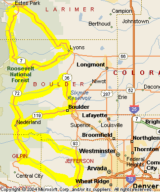
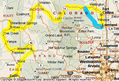
Today is a bit of a contradiction for our riders. It will be one of the shortest days in terms of miles but it will be one of the biggest days in terms of where they’re going. Today’s ride will go over Trail Ridge Road and to the top of Mount Evans, along with some other pretty good stretches. Here’s the map and here’s the enlarged view.

Loveland to Golden, via Trail Ridge Road and Mount Evans

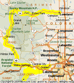
Right off the bat, Steve and the group head out on US 34 up the Big Thompson Canyon. What a nice way to start the day. This beautiful canyon goes up to Estes Park, which, despite the name, is a town, not a park. The park people sometimes get it confused with is Rocky Mountain National Park. We’ll get to that later.

Because this will be the first time for these folks going up the Big Thompson, they’re proably going to want to just ride the whole canyon. If you’ve done it before, however, and are interested in an alternate route, you can take CO 43 between Drake and Estes Park. There are some hairpin turns on this that might make you think you’re in over your head.

At the head of the canyon is Estes Park. This is a very nice town but it has gotten very crowded. Count on slow going through here as you make your way to the entrance to Rocky Mountain National Park. Oh, and that big old lodge you see on the hillside? That’s the Stanley Hotel, where they filmed “The Shining” with Jack Nicholson and Shelley Duval. Red rum anyone?

US 34 continues through Estes Park and into Rocky Mountain National Park and then winds its way up over Trail Ridge Road, the highest through road in the U.S. This road closes for the winter but should be open by the time Steve and crew get there. Trail Ridge Road is one of the must-do rides in all of Colorado. Plan to take your time. You really won’t have any choice, but you won’t want to rush anyway.

The highway comes down from Trail Ridge Road into the town of Grand Lake. This is a very nice town and well worth a stop. From there, US 34 goes on down to where it hits US 40 just outside of Granby. Here Steve and the others will need to make a decision. He’s considering taking a quick run west on US 40 to Kremmling and then back. He just doesn’t want to miss anything. What there is on that stretch is Hot Sulphur Springs and a nice bit of canyon. Is it worth the extra time and miles? I don’t know. They probably ought to check the time and see how much of the day has already elapsed. This may be a short ride in mileage today but it’s far from done at this point.

Whatever they do, eventually they’ll head south on US 40 to Winter Park and then up and over Berthoud Pass. Berthoud is another very nice pass, and the road is in very good condition thanks to a lot of money spent on upgrades in the last few years. From the pass, US 40 runs down to Empire, where it meets I-70.

A short jaunt east on I-70 brings the group to Idaho Springs, where they will get off the interstate onto CO 103 over Squaw Pass. Squaw Pass is a nice ride on its own but the real draw here is that this is the route to CO 5 that takes you to the top of Mount Evans. If you thought Trail Ridge Road was a slow ride, be prepared to go even slower. I don’t recall for sure but I believe the speed limit on this entire stretch is 10 mph. There is also a toll, by the way. That’s OK. It’s worth it, and you pay less for motorcycles. And no matter what time of year it is, don’t be surprised if you get snowed on a little.

After Mount Evans the route continues on CO 103 toward Bergen Park. A left onto CO 74 a few miles brings you to another left onto Jefferson County Road 65, which meets up with I-70 a little east of Idaho Springs. More importantly, it meets up with US 40 at the same spot and it’s really US 40 that we want. US 40 parallels I-70 on the north as it goes down the west side of Floyd Hill. At the bottom of Floyd Hill both roads intersect US 6, which is our ultimate goal.

US 6 winds down through Clear Creek Canyon, coming out at Golden. One of the first things you’re sure to notice is the Coors Brewery. You may even smell the malt before you see the plant. Golden is tonight’s stopping point, so this day’s ride is done.

New Zealand Rides The Rockies – Day 8

Monday, March 10th, 2008

Recap: Steve and some buddies are coming from New Zealand in 2009 for some motorcycle touring in Colorado and Utah. This series of posts lays out their proposed routes, with my comments. Your comments are welcome as well.

Day 8

Today is going to be a bit more relaxed for our riding crew, as the distance is less than 300 miles. These guys have been racking up more than 300 miles almost every day. Assuming the start is indeed Eagle, they’ll be heading up to Steamboat Springs, over Rabbit Ears Pass, across North Park, and then up Cameron Pass, down Poudre Canyon and eventually end up for the night in Loveland. Here’s the map; click to see it enlarged.

Eagle to Loveland

Leaving from Eagle, Steve and the gang will head east a few miles on I-70 until they get to Wolcott. Here they turn north on CO 131 headed for State Bridge. At State Bridge they will have a decision to make. The original plans called for taking the Trough Road northeast through Radium to Kremmling. What they had not counted on, however, is the fact that this is a gravel road. They’re not fond of gravel on big street bikes, and Steve said he’s also unsure whether their rental contract allows riding on gravel.

While I don’t know about the contract, I do know about the Trough Road. It is very good gravel and a very nice ride. The guys I ride with don’t like gravel either, but it was one of them who showed us this road in the first place and we took it. It was great, no problems at all.

So if they take the Trough Road, our riders will come out at Kremmling, where they will pick up US 40 west for just a few miles to CO 134, which crosses Gore Pass and reunites them with CO 131 at Toponas. The alternative would be just to stay on CO 131 at State Bridge, skipping the Trough Road and Gore Pass. It’s up to you guys, but it’s a short day anyway, so I’d say do it.

Either way, the route now continues up CO 131 to meet US 40 a little south of Steamboat Springs. They’ll ride on into Steamboat, probably have lunch and get gas, and then backtrack a little as they head east on US 40 over Rabbit Ears Pass. This is a good one and will be an enjoyable ride. Descending, they will reach Muddy Gap Pass and the turn-off for CO 14, taking them north into North Park and to Walden. At Walden they stay on CO 14, which turns southeast and passes through State Forest State Park and up over Cameron Pass. There’s some mighty good scenery on the way up.

On the way down the highway passes through Poudre Canyon. Poudre Canyon is one of the prettiest canyons in Colorado so this will be a treat. Be sure to stop a few times and enjoy it. Sleeping Elephant Mountain is particularly interesting.

Moving on down the canyon they will eventually come out on US 287 north of Fort Collins and follow that highway to Loveland and the end of today’s ride. That will mean doing some city riding but Fort Collins is a nice town so it’s not a bad thing to do. However, there is an alternative.

Alternate Route

It just happens that I know an excellent alternate route that will allow the group to totally skip Fort Collins and enjoy some more mountain/canyon riding. As they get down close to the mouth of the canyon, there is a turn-off for Larimer County Road 27, otherwise known as Stove Prairie Road. This is a nicely paved, very windy two-lane that rises up over the ridge separating Poudre Canyon from Buckhorn Canyon. The Buckhorn then carries you down to Masonville. At Masonville you can either go up around Horsetooth Reservoir and drop down into Fort Collins on the south side or take CO 56 down to where it meets US 34 coming out of the Big Thompson Canyon. From there it’s a short ride east to Loveland. Enjoy.

New Zealand Rides The Rockies – Day 7

Friday, March 7th, 2008

Recap: Steve and some buddies are coming from New Zealand in 2009 for some motorcycle touring in Colorado and Utah. This series of posts lays out their proposed routes, with my comments. Your comments are welcome as well.

Day 7

All right, in cruise ship terminology, today is a repositioning day. Our crew is in Torrey, UT, and needs to get back to Colorado. The destination is not totally certain as yet, our riders just know they want to be in a general area, set up for the next day’s ride. Within that general vicinity I would recommend Eagle, and that is how I’ve set up the map. As always, click to view the map in larger format.

Torrey to Eagle

They’ll be leaving Torrey and heading east on UT 24, which turns north at Hanksville and hits I-70 a bit west of Green River. Again, I’ve been on this road but my recollection is not clear so I can’t tell you much about it.

Their plan is to stay on I-70 all the way into Colorado. This is wide open territory and they’ll blast along.

Once they enter Colorado it’s only a short ride to Fruita, where they will turn off for a cruise through Colorado National Monument on Rim Rock Drive. You may recall that Rim Rock Drive was on the agenda for Day 4 of this trip, but Steve tells me he likes my idea of doing it on Day 7 instead, so the switch has been made. Here’s what the National Park Service has to say about the Monument:

Colorado National Monument preserves one of the grand landscapes of the American West. Sheer-walled canyons, towering monoliths, colorful formations, desert bighorn sheep, soaring eagles, and a spectacular road reflect the environment and history of the plateau-and-canyon country.

Coming out of the Monument at the east end, they’ll come into Grand Junction, where they’ll probably want to pick up Business 70 to reconnect with I-70 on the east side of town. Then it’s back on the superslab. This superslab gets interesting, though, pretty soon. Exiting the Grand Valley it twists up into Debeque Canyon, and here you see again how, compared to other states, even the interstate through much of Colorado is darn scenic. Here, it runs alongside the river, through winding canyons, occasionally coming out into wider valleys, but there are always mountains on either side of you.

The road opens out as you get to Rifle. Along this stretch you’ll notice something very interesting. If you’re traveling at night it looks like there are fully lighted Christmas trees dotting the hillsides all over. During the day you can see that these are in fact drilling rigs. And they’re everywhere. High energy prices have driven oil and gas exploration like never before. This particularly matters to all travelers because the intrastructure has not kept pace with the population. Do NOT come to the Rifle area expecting to just find a motel room for the night. There are none available. The drillers are living in them. You’ll probably be lucky if you can even reserve one in advance. Plan to stay either in Grand Junction or in Glenwood Springs.

Glenwood Springs is definitely worth a look if you’re not spending the night there. Get off the highway and cross the river to the heart of town. This is a good place to stop for food and drink.

Then it gets gorgeous. Going east from Glenwood Springs you enter Glenwood Canyon. Excuse the superlatives, but this is probably the most beautiful section of interstate anywhere in this country. It was the very last piece of the original interstate system to be completed because the preservationists fought tooth and nail to keep it out altogether. Their resistance forced the government to preserve the canyon as much as possible and we all are beneficiaries of that. Take your time cruising through, and make a point to stop where it’s permitted.

Once you’re out of the canyon it’s just a short ride to Eagle. This is a good place to end this day’s ride.

New Zealand Rides The Rockies – Day 6

Wednesday, March 5th, 2008

Recap: Steve and some buddies are coming from New Zealand in 2009 for some motorcycle touring in Colorado and Utah. This series of posts lays out their proposed routes, with my comments. Your comments are welcome as well.

Day 6

All right. Today the group is doing a day ride and returning to Torrey for a second night. Here’s the map; click to see it enlarged.

Torrey day ride

Leaving Torrey, the riders head south on UT 12 through Boulder and Escalante. The road turns west and they pass through Bryce Canyon National Park, eventually meeting US 89 a little north of Hatch. They take a right and head north on US 89 as far as Panguitch, where they pick up UT 143 heading southwest.

Just when they reach Cedar Breaks National Monument they pick up UT 148, which carries them through the Monument to UT 14. A left turn onto UT 14 takes them back through Hatch to the intersection with US 12 again, and the rest of the day’s ride is retracing the route that got them here.

I’d like to tell you more about this ride, and I know I’ve been on most of these roads, but it hasn’t been recently. That’s why I pretty much stick to Colorado on this website, it’s what I know really well. If you have information to share about this route please leave a comment. Thanks.

Update

It seems the spammers have latched onto this particular post so I’m going to need to turn comments off on this one temporarily. After they fail to do their dirty work they’ll move on and I can open up comments again. Sorry for any inconvenience.

New Zealand Rides The Rockies – Day 5

Monday, March 3rd, 2008

Recap: Steve and some buddies are coming from New Zealand in 2009 for some motorcycle touring in Colorado and Utah. This series of posts lays out their proposed routes, with my comments. Your comments are welcome as well.

Day 5

Today our riders from down under are leaving Colorado for a couple days riding in Utah. Steve has been to Utah a couple times and knows some good roads so he’s going to be the tour guide here and I’ll just show you his plans.

The route today begins in Cortez and heads northwest into Utah. The destination is Torrey, but after checking in to their motel, the group will offload baggage and continue on a loop ride before returning to Torrey. Here’s the map. Click to see the larger map.

Cortez to Torrey

Steve and crew will head out of Cortez on US 491 through Lewis, Cahone, and Dove Creek and cross into Utah just east of Monticello. This is pretty much just high prairie. At Monticello they hit US 191 and head south through Blanding to where they meet UT 95. Here they turn west with a possible stop at Natural Bridges National Monument, and on through the Glen Canyon National Recreation Area. Continuing in this northwesterly direction, they reach Hanksville and UT 24.

Turning west on UT 24, they cross through Capitol Reef National Park and reach Torrey. Disemcumbered, they then continue west on UT 24 until they reach UT 25 southwest of Fish Lake and the Fishlake National Forest. On this road, they run up past Fish Lake and loop around Johnson Valley Reservoir, then hook up with UT 72 back to Loa. At Loa they return to UT 24 and backtrack to Torrey for the night.

Now, we’ve ridden all over Utah but I’ve never heard of this road, so I asked Steve how he found it and what it’s like. Here’s what he told me:

We did our first trip in 2004 and, since it’s a major expense for us, I did as much research as I could. The ABSOLUTE best thing I ever did was buy a book called Motorcycle Journeys Through The Southwest by Marty Berke. Without the guidance from this book (and with no websites like yours available) we would not have found some of these fantanstic roads.

The “loop” road up around Fish Lake and back down again is one of the BEST rides I have had anywhere (inc NZ). Only lasts about 25(ish) miles but both times we have been there it has been deserted, twisty, great surface and dry – fabulous. Normally, we check into a motel in Torrey and make that an afternoon ride without luggage.

In fact that was one of the best days on last year’s trip (we started from Kayenta in UT) and included 95/24 from Blanding to Torrey, another great section.

So there you have it. Take it from the guy who knows.

New Zealand Rides The Rockies – Day 4

Friday, February 29th, 2008

Recap: Steve and some buddies are coming from New Zealand in 2009 for some motorcycle touring in Colorado and Utah. This series of posts lays out their proposed routes, with my comments. Your comments are welcome as well.

Day 4

Leaving Ouray this morning, our Kiwi band heads north on US 550 through Montrose, and Delta, and on up to Grand Junction. Their plan is to ride the Rim Rock Drive route through Colorado National Monument, and then head back south, taking the Unaweep Tabeguache Scenic and Historic Byway through Gateway and Naturita, past Telluride and over Lizard Head Pass down to Cortez. This is going to be a bit of riding, totaling about 335 miles. Here’s the map. Click to see a larger version.

Ouray to Cortez via Colorado National Monument

The ride up US 50 is uneventful and fairly fast. A significant portion of this road has been made into four-lane divided highway in recent years. Once they reach Grand Junction it will be necessary to enter the town and stay on the US 50 bypass on the south side before turning off onto Glade Park Road, the road that leads to Colorado National Monument. In the Monument, Rim Rock Drive is clearly marked, winding its way though and exiting to the north toward Fruita. Colorado National Monument is described as being a little bit of red-rock Utah within Colorado, and that’s not a bad description.

That’s not the only bit of red-rock Utah in Colorado that our crew will see today, however. Leaving the Monument they will head back east on I-70 to rejoin US 50 and backtrack a few miles to the south, to CO 141 and the Unaweep Tabeguache Scenic and Historic Byway. Along this road you’ll pass through farmland, areas of wild rock formations, and ultimately to a stretch that you would swear was Utah, except that red-rock cliffs don’t stop at the state line and this is still Colorado. Who knew? Additionally, one of the more interesting historical sights is the hanging flume, an old water channel built onto the sheer-rock cliffs. This is one of those things you’ll look at and wonder “How in the world did they do that?”

For a while after leaving the river this route crosses some high prairie and you’ll probably make some pretty good time. A little east of Naturita you leave CO 141 and pick up CO 145 to Norwood and Placerville. After passing through Placerville you start going up and what you’re really doing is coming around the back side of the mountains that enclose Telluride. Telluride itself is not actually on CO 145, so you have to take the county road about 5 miles to the town. Do. The setting for this little mountain town is simply awesome. And if you have the time, take the free gondola up to get a good look from above.

Heading south from Telluride, the next pass is Lizard Head Pass. Off to your right, high up on the ridge, you’ll see the rock formation that gave it the name. From there it’s down hill, down the valley, on to Cortez, where today’s ride ends.

Alternate Route

I have just one suggestion for this day, and it really only works when you consider the route the remainder of this trip will be taking. This is Day 4 and on Day 5, Steve and crew are heading over into Utah. When they return to Colorado on Day 7 there is not a lot on the agenda as they head for a night in the Eagle/Vail area. It might make good sense to skip Colorado National Monument on Day 4 and swing through there on Day 7, starting at the Fruita end and coming out at Grand Junction. Then on Day 4 you would just come north to the turn-off to CO 141 and the Unaweep highway. That would trim about 50 miles and at least an hour and a half off an otherwise long day, and add more interest to Day 7. Just a thought.,