Posts Tagged ‘Colorado National Monument’

Route For A Five-Night Colorado Ride

Monday, March 18th, 2024

It’s pretty dang hard to beat motorcycle riding in Colorado.

Over the years I have received numerous requests from folks coming to Colorado to ride, asking me for recommendations on a route. I’m always happy to oblige and each one is different, with different parameters of what they want, how long they have . . . that kind of stuff.

The most recent is from Kevin in Indiana. He said he and a buddy have ridden many of the unpaved passes throughout the state by now they want to come on street bikes with their wives and do the pavement. Rather than the hub and spoke riding they have done out of Frisco and Crested Butte, Kevin asked for “an epic continuous trip” for his buddy’s 60th birthday.

Here’s what I sent him.

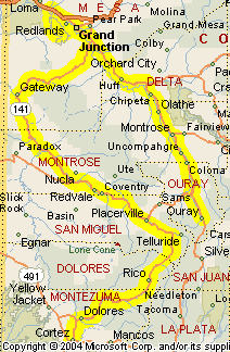
OK Kevin, I have something mapped out. A couple days are a bit over 250 but under 300. Obviously you can make any changes you see fit.

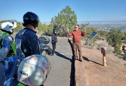
Figuring on you starting in Denver you can go north to Loveland, up the Big Thompson Canyon to Estes Park, over Trail Ridge Road to Granby and then take US 40 on to Kremmling for the night. This is shorter than 250 but with Trail Ridge Road you’ll definitely want to be making stops. You will need to make a reservation to get into Rocky Mountain National Park. The less busy entrance is the Fall River Road entrance. Park entrance differs if you want to see the park or just go through. I believe they allow people passing through in without reservations both early and late. You’ll see plenty of the park just going through. If you don’t make a reservation you might want to spend the night in Estes so you’ll be right there to go through early. That’s what my wife and I did last year.

(As an alternative to Loveland and the Big Thompson you could go up any number of passes to the Peak-to-Peak Highway and take it north to Estes.)

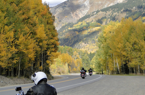
From Kremmling take US 40 west a bit further and turn onto CO 134 over Gore Pass. At Toponas go south to Wolcott and I-70, then east to the Minturn exit and take Tennessee Pass to Leadville, then a bit further south to Twin Lakes and go over Independence Pass through Aspen and down to Carbondale. From Carbondale take CO 133 over McClure Pass down to Hotchkiss for the night.

From Hotchkiss go west on CO 133 to CO 65 through Cedaredge and over the Grand Mesa. When the road forks north of Mesa stay on 65 (left fork) on to I-70. Take I-70 to Fruita then take the road south through Colorado National Monument, on Rim Rock Drive. Exiting the south end of the monument find your way to US 50 south and go maybe 8 miles to Whitewater. Take CO 141 west toward Gateway, then south to Telluride. This is the Unaweep Tabeguache Scenic Byway. Spend the night in Telluride.

From Telluride go over Lizard Head Pass down to Cortez, US 160 east to Durango, then US 550 north over Red Mountain Pass (the Million Dollar Highway) to Montrose, then east on US 50 to Gunnison. Overnight in Gunnison.

From Gunnison, run back a few miles to the Blue Mesa Reservoir and turn south on CO 149 through Lake City over Slumgullion Pass, through Creede and down to South Fork. Take US 160 west over Wolf Creek Pass to Pagosa Springs, then turn south on US 84 down into New Mexico to Chama. Go northeast from Chama over Cumbres and La Manga Passes on CO 17 up to Antonito, then US 285 north to Alamosa. Spend the night in Alamosa.

From Alamosa you have several options to get back to Denver. You can just take CO 17 north to pick up US 285 and follow that all the way to Denver. Or you can take US 160 east over La Veta Pass to Walsenburg, then go right back west and north out of Walsenburg on CO 69 to Westcliffe, then east on CO 96 on to Pueblo or up to Florence, to Penrose, and on to Colorado Springs.Or make your way to Canon City and then, because you guys are comfortable on gravel, take Phantom Canyon Road (CR 67) up to Cripple Creek, CR 61 up to Divide, pick up US 24, and take that to Woodland Park. At Woodland Park you can either continue on US 24 to Colorado Springs or go north on CO 67 through Deckers to Pine to US 285 southwest of Conifer. Then take 285 on into Denver.

This would be a heck of a good ride. Pick and choose what you like.

Besides being a nice guy and mapping this out for Kevin and his crew, I’ve done myself a favor here. First off, I got this blog post out of it. At this time of year it is harder than during the summer to keep coming up with blog ideas. But I may make it a triple. I figure this might well be a good basis for planning the 2025 OFMC trip. The 2024 trip is already planned but I might incorporate a lot of this for 2025. Also, I’ve been thinking for a long time about putting a ride together for the RMMRC. This might also go a long way toward that plan. We’ll just have to see what develops.

Biker Quote for Today

You might be a Yuppie biker if your only scoot has been a Knucklehead & you don’t even know what that is.

On The Way To Ouray

Thursday, September 23rd, 2021

Ralf discusses plate tectonics, uplift, and erosion in a place where you can really see the results.

Dave and I loaded up and rode across the street to join the rest of the RMMRC group on our four-day ride the second morning. While I parked, Dave disappeared. After a few minutes it occurred to me and I asked Susan if they had all already gotten gas. She said yes and I realized that was probably where Dave had gone. I figured I’d better do so, too.

I filled up and used the facilities one last time and as I came out I saw a group of bikers heading down Horizon Drive toward the westbound I-70 ramp and then realized it was my group. They were leaving without me. I guess I should have said something to someone other than Susan about getting gas.

I hopped on and blasted away to catch up but this is a fast group of riders so that didn’t happen at all quickly. Meanwhile I considered the situation. I recalled some discussion of riding Colorado National Monument. Our ultimate destination this day was Ouray so it would make the most sense if you’re going to ride the monument to start on the Fruita end. But they might not; could I get to the exit to the other end before I lose sight of anyone? Regardless, I figured if I didn’t find them I would ride the ride I considered nicest, which would be to go to Fruita, ride the monument, and then meet them all at lunch down in Gateway.

Just as I got to the exit to the non-Fruita entrance to the monument I caught a glimpse of riders ahead on the interstate so I figured that was them and I cranked the throttle even harder. Just as they were exiting at Fruita I pulled up alongside Charley, who was riding sweep with his wife Karen on behind. Charley waved me on ahead of him and I was back with the group.

We rode the monument, stopping a couple times so Ralf, a hydro-geologist, could give us a little education on plate tectonics and uplift and erosion. Ralf is very knowledgeable so these were interesting presentations.

Leaving the monument we headed down US 50 to Whitewater, where we turned west on CO 141 toward Gateway and the Unaweep Tabeguache Scenic Byway. The Paradox Grille in Gateway is excellent, but also on our agenda was the Gateway Auto Museum. I’ve been to Gateway numerous times, eaten at the Paradox several times, but I had never been in the museum. Let me tell you it’s worth it. They have some amazing cars in there.

The road to Gateway is very nice but the road south from there to Naturita is spectacular. If you are familiar with the canyon country of Utah, this is a small area where the canyons crossed the state line and made their way into Colorado. Beautiful country and a beautiful ride.

We stayed on CO 145 until Placerville and then took CO 62 on to Ridgway. From there it’s just a few miles south on US 550 to Ouray. Coming into town we saw signs warning that 550 over Red Mountain Pass would be closed for construction beginning at 8:30 a.m. the next day. Oh, oh. We’re going to have to get an early start. And it’s going to be cold.

Biker Quote for Today

We know you’re a poser if you set at least one mirror, if not both, to reflect yourself.

Some Terrific National Parks To Ride In

Thursday, June 25th, 2015
Motorcycle At Crater Lake

Riding the rim road at Crater Lake at sunset.

Judy and I recently took a road trip that carried us to 10 national park system units, as they’re called. That is, these were national parks, national monuments, and a few others that go by “national historic site” and such. Growing up, my family would load up the car each year and take trips to national parks all over the country. On top of that, I just ended two and one-half years working at the National Park Service. They’re really in my blood, and Judy loves them, too.

There’s a saying that makes total sense here: They don’t put national parks in ugly places. So it’s no surprise that there are a lot of parks that are terrific for motorcycling. Here are some we visited on this trip.

We started out at Dinosaur National Monument, which we had also been to last year. Last year we did the middle section of the park and that was good for dual-sport bikes. This year we went to the west end. Not too much riding over there. Just some dinosaur bones to look at mainly.

Our next stop was Golden Spike National Historic Site. This is where they put in the golden spike connecting the transcontinental railroad. Very cool trains there but no riding.

On to City of Rocks National Reserve in Idaho, which is a very cool place. If you are on a dirt bike or dual-sport this would be a good place to go; the roads are not paved. We did see a couple people on dirt bikes.

Next was Hagerman Fossil Beds National Monument. Unfortunately there was little to see or do here because the research center/visitor center called for in the establishing legislation has never been funded.

And by the way, as an aside: if you have ever wondered why some places are national parks and some are national monuments, and some change from one to the other (Black Canyon of the Gunnison), here’s the very simple explanation. National parks are created by congressional legislation. National monuments are created by the president under the authority given under the Antiquities Act of 1906. In the case of the Black Canyon, some president declared it a monument and later Congress decided to make it a park. Now you know.

After Hagerman our next park was John Day Fossil Beds National Monument. As with several of these parks, the only reason I even knew they existed was because I edited their planning documents, primarily their foundation documents. In the JODA foundation (I’ll explain in a moment) there was discussion about the issue of the unwelcome noise created by lots of motorcycles. I took the liberty of rewording that text to make it clear that the issue was loud motorcycles as well as loud trucks or any other loud vehicles.

Anyway, that discussion in the foundation should be the tip-off: there are some terrific roads in John Day. A good bit of the park is centered on a couple steep canyons and we all know that steep canyons mean beautiful, twisty roads. And the bikers in Oregon know it. There were plenty of them. You owe it to yourself to check it out sometime if you’re up there.

And JODA? Another bit of inside information. National Park Service short-hand for the various park units is to take the first two letters of the first two words of the name. Thus, John Day Fossil Beds National Monument is JODA. Dinosaur National Monument is DINO, because they do not include the “national whatever” portion.

Then came Crater Lake. (That’s CRLA, you know.) However, long before we got to Crater Lake we were in the mountains of Oregon and there was nothing but great motorcycle roads. Western Oregon is just pretty dang beautiful.

As for Crater Lake, we actually came into the park on the longest, straightest road I’ve ever seen outside of crossing the Bonneville Salt Flats. But when you get up to the rim there is a road encircling the lake that is in the caldera of this volcano that blew its top long ago. This road is so twisty and narrow, with no shoulder and in most instances a pretty serious drop-off, such that we who are accustomed to mountain driving still found it a bit intimidating. Of course on a motorcycle it would we wonderful, as long as you look out for the terrified flatlanders hugging the center of the road and don’t try to look at the lake while you’re moving.

Going down from the rim and out the other side the roads are more interesting and twisty, the way you would expect coming off a mountain.

Not too far from Crater Lake is Oregon Caves National Monument and the only way to get there is to get off the main highway at Cave Junction and take a narrow, winding 19-mile road up the hill. Need I say more?

Heading south in to California we came to Lassen Volcano National Park. This place was a treat. There is a road that goes through the park and it takes you to most of the best places in the park. Climbing to great views, interesting stops. I definitely recommend Lassen (LAVO).

We blasted across Nevada and spent a night in Ely–you can’t beat the Hotel Nevada. Next morning it was on just a short distance to Great Basin National Park. They are two draws to Great Basin. The first is Lehman Caves, which is what initial land was set aside for and the name it used for many years. Then they expanded it to become what it is today. The second is the drive up 13,063-foot Wheeler Peak. Yeah, you guessed it, you’re going up a mountain. It’s a twisty narrow road with great views.

Our 10th and last park was Arches National Park. This is another of those that used to be a monument but was made into a park. I don’t know that there’s much advantage to seeing Arches on a bike versus a car, it’s the arches that are of interest and in almost every case you have to get out of the car or off the bike to go see them.

Then we headed home. So to sum it up, there are great motorcycle roads in six of these parks: DINO, JODA, CRLA, ORCA, LAVO, and GRBA. Get out there and do some riding!

Biker Quote for Today

I enjoy going on motorcycle trips and stopping in small towns and enjoying drinks with the locals. — George Clooney

New Zealand Rides The Rockies – Day 4

Friday, February 29th, 2008

Recap: Steve and some buddies are coming from New Zealand in 2009 for some motorcycle touring in Colorado and Utah. This series of posts lays out their proposed routes, with my comments. Your comments are welcome as well.

Day 4

Leaving Ouray this morning, our Kiwi band heads north on US 550 through Montrose, and Delta, and on up to Grand Junction. Their plan is to ride the Rim Rock Drive route through Colorado National Monument, and then head back south, taking the Unaweep Tabeguache Scenic and Historic Byway through Gateway and Naturita, past Telluride and over Lizard Head Pass down to Cortez. This is going to be a bit of riding, totaling about 335 miles. Here’s the map. Click to see a larger version.

Ouray to Cortez via Colorado National Monument

The ride up US 50 is uneventful and fairly fast. A significant portion of this road has been made into four-lane divided highway in recent years. Once they reach Grand Junction it will be necessary to enter the town and stay on the US 50 bypass on the south side before turning off onto Glade Park Road, the road that leads to Colorado National Monument. In the Monument, Rim Rock Drive is clearly marked, winding its way though and exiting to the north toward Fruita. Colorado National Monument is described as being a little bit of red-rock Utah within Colorado, and that’s not a bad description.

That’s not the only bit of red-rock Utah in Colorado that our crew will see today, however. Leaving the Monument they will head back east on I-70 to rejoin US 50 and backtrack a few miles to the south, to CO 141 and the Unaweep Tabeguache Scenic and Historic Byway. Along this road you’ll pass through farmland, areas of wild rock formations, and ultimately to a stretch that you would swear was Utah, except that red-rock cliffs don’t stop at the state line and this is still Colorado. Who knew? Additionally, one of the more interesting historical sights is the hanging flume, an old water channel built onto the sheer-rock cliffs. This is one of those things you’ll look at and wonder “How in the world did they do that?”

For a while after leaving the river this route crosses some high prairie and you’ll probably make some pretty good time. A little east of Naturita you leave CO 141 and pick up CO 145 to Norwood and Placerville. After passing through Placerville you start going up and what you’re really doing is coming around the back side of the mountains that enclose Telluride. Telluride itself is not actually on CO 145, so you have to take the county road about 5 miles to the town. Do. The setting for this little mountain town is simply awesome. And if you have the time, take the free gondola up to get a good look from above.

Heading south from Telluride, the next pass is Lizard Head Pass. Off to your right, high up on the ridge, you’ll see the rock formation that gave it the name. From there it’s down hill, down the valley, on to Cortez, where today’s ride ends.

Alternate Route

I have just one suggestion for this day, and it really only works when you consider the route the remainder of this trip will be taking. This is Day 4 and on Day 5, Steve and crew are heading over into Utah. When they return to Colorado on Day 7 there is not a lot on the agenda as they head for a night in the Eagle/Vail area. It might make good sense to skip Colorado National Monument on Day 4 and swing through there on Day 7, starting at the Fruita end and coming out at Grand Junction. Then on Day 4 you would just come north to the turn-off to CO 141 and the Unaweep highway. That would trim about 50 miles and at least an hour and a half off an otherwise long day, and add more interest to Day 7. Just a thought.,