Archive for the ‘Info to Add to Website’ Category

Maybe Now You Can Comment

Thursday, April 7th, 2022

I hope this new spam-blocker lets you post comments again.

I’ve been doing this blog for more than 10 years and over that time I have received very few comments, and I’ve never understood why. Some people who I actually know in person will occasionally send me emails with comments but I’ve always wondered why they don’t just post responses on the blog. That’s what happens on most blogs I’ve seen.

Now, early on I got a lot of comments, but they were about 99.5% spam. So I set up a spam-blocking plug-in on the site and that took care of things. But then I hardly got any comments at all.

Well, at some point I figured out the biggest reason was that anytime anyone tried to post a reply the system failed to carry through. The blog is run on WordPress so I went to an online meeting of a WordPress Meet-Up and asked if anyone there had any ideas. They all looked at the site right then as we were meeting and the only suggestion anyone could offer was to check to see if the plug-ins were causing a conflict. They said I should deactivate all of them and then reactivate them one by one and test each time to see if the system was working. If you activate a plug-in and suddenly things stop working then that’s your problem, probably.

I never got serious about this, but deactivated a couple that I figured were not essential, but no change. But just now I decided to try again. I was running one spam-blocker and it was showing that it needed to be updated. I clicked to update but that took me to a page where it said this domain name was available. What?

So I googled the name and found comments about the company shutting down and the plug-in causing systems to fail. Holy crap! So I deactivated that plug-in and tried to post a comment. It went through. And significantly, in the bare minute or so that that took me, I also received a spam comment. Just that quickly!

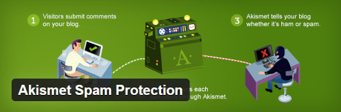
OK, I definitely need a spam-blocker so I reactivated another one I had installed but had been deactivated, Akismet. I don’t remember why I deactivated this one, quite some time ago, but maybe it was because they quit offering a free install and I was being cheap. Now they have a “pay what you want” option for non-commercial blogs so I chose that and agreed to pay a dollar a month. And boom, now I have a spam-blocker and it looks like you can finally offer comments again.

Anyone who wants to give it a try, please do. I’m going to be really pleased if this turns out to have solved this issue. Thanks.

Update April 11: Yeah, it looks like it’s working now. So is the spam-blocker. I’m now seeing hundreds of spam comments showing up in the spam folder every few days. If I had to dig through those looking for that stray actual comment it just wouldn’t be worth it.

Biker Quote for Today

My girlfriend, Ruth, fell off the back of my motorcycle. I rode on, ruthlessly.

Off The Pavement Outside Cripple Creek

Monday, September 13th, 2021
Phantom Canyon Road

This is actually one of the wider spots along the Phantom Canyon Road–and notice how smooth it is, at least now.

Most of this website was built more than a few years ago now but it’s never really finished. There is always stuff that needs to be updated and there are always roads I want to pay more attention to. And more and more those roads are unpaved. I mean, let’s face it, I’ve already addressed most of the paved roads in the state that are worthy of attention, but there are lots of unpaved roads, and some of them are fabulous.

One area that has had my attention lately is the area around Cripple Creek. Unlike the pages I’ve built for passes and for canyons, the page I envision for Cripple Creek would focus on all the roads leading to it. Because there are quite a few of them. And there’s not a one of them that’s not interesting or worth riding. But they’re not all paved.

With all this in mind, I headed out last week by myself to refamiliarize myself and to shoot photos to go on this new page. It turned out to be a longer day than I had anticipated, but man did I have a good time.

I headed out of Denver on US 285 as far as the turn-off at Pine Junction, going south on CO 126 through Pine and down to Deckers, where the road becomes CO 67. Up to this point, amazingly, it had been cool enough that I wore a down vest over my t-shirt inside my mesh jacket. I stopped at Deckers to use the john and stretch my legs and I took the vest off now.

CO 67 continues south from Deckers until it reaches Woodland Park and there I turned west on US 24. This took me the short distance to Divide, where I turned south once again on CO 67. Actually, it was CO 67 all the way; US 24 and CO 67 are the same along this stretch.

Heading south on CO 67 is the main road into Cripple Creek and all by itself it is quite scenic. The road rides high and there are numerous view points with nice scenery. And to top it off, as you crest the hill and descend steeply into Cripple Creek you have just gone over Tenderfoot Pass. Not that it’s well marked or anything, but it’s there.

But I didn’t go that route. Just a few miles before Cripple Creek CO 67 does a hard right but if you go straight you’ll be on Teller County Road 81, which goes to Victor. I don’t know why but I’ve always had the idea this road was unpaved, but it isn’t. It’s paved all the way. And, of course, the paved road goes on around to Cripple Creek so it’s a loop.

Victor was where I was to pick up the first of the day’s gravel roads: the Phantom Canyon Road. Coming this direction you actually come to the Phantom Canyon Road before you even get into Victor. I saw the sign for County Road 86 and thought that might be it but went on into town before I stopped to check the map. Sure enough. No matter, it wasn’t more than half a mile.

So I turned down County Road 86 and I had a little trepidation. The truth is, although I’ve had this V-Strom for a number of years now, and I got it specifically to be able to ride off the pavement, I just haven’t done all that much of it. Certainly not as much as I have wanted to do. And at this point, what dirt-riding skills I have developed were a bit rusty.

Not to worry. The road was amazingly smooth. So smooth, in fact, that it appeared it had only recently been graded. That impression was confirmed in a short while when I encountered the road grader at work.

The Phantom Canyon Road used to be a narrow-gauge train route so there were a couple tunnels cut through sheer rock walls and a lot of the road hugs the cliff with canyon way down below–and of course no guard rails and not so wide that two cars can pass comfortably unless one hangs back in wider spot when they see the other one coming. Absolutely fine for motorcycles, though.

Altogether, from Victor to where you hit US 50 east of Canon City it’s about 34 miles. It’s slow going so figure on an hour minimum. And it really is a pretty good road all the way, especially right now. You won’t be disappointed in the scenery.

I stopped in Canon City for lunch and that’s where I’ll leave this today. I’ll pick up the tale next time.

Biker Quote for Today

Why motorcycles are better than women: If your Motorcycle is too soft, you can get different shocks.

Punting, And A Question

Thursday, June 17th, 2021

A ride one day with some sidecar folks.

I’ve been busy and distracted and I find myself today looking for something to write about here. So I’m going to do something very unusual: punt. But I also have a question I want to ask you.

I’m putting in the usual photo of a motorcycle and I’m closing with the usual Biker Quote for Today. But that’s about all.

But about that question: Do you see that (now really old) photo of me on the right? Do you see underneath it those links for “Entries (RSS) and Comments (RSS)? Does anyone still use those? Do you even know what they are? Unless someone asks me not to I’m just going to eliminate that.

It used to be that RSS, Really Simple Syndication, was a way for the reader to have all their blog feeds presented in one application. You would have an aggregator and tell it which RSS feeds you wanted and any time a new post went up you would see it in your aggregator.

But here’s what Digital Trends says about RSS these days: Is it still used online? Yes and no. RSS feeds are certainly still present (more on this later), but they aren’t as dominant as they once were. Social media sites like Facebook, Twitter, LinkedIn, and others have become the go-to option for following sites, watching feeds, and learning about the latest content.

Frankly, I’m not even sure this code still works. So unless someone responds telling me they use the RSS feature I’m going to eliminate it.

Now on to what I know many of you primarily come here for, the quote!

Biker Quote for Today

The Tin Man to Dorothy: I did want a heart, but I decided a motorcycle would be a lot cooler. Besides, now I can give you a ride back to Kansas.

Smokin’ Mama!

Thursday, October 1st, 2020
motorcyclists at Brainard Lake

Regrouping up at Brainard Lake.

Wednesday seemed like it would be a great day to ride, so Roy planned a fall color RMMRC ride up the Peak-to-Peak. As I headed out, though, going west on Hampden, I couldn’t even see the foothills. Either I was heading into a serious rainstorm or a ginormous cloud of smoke.

I assumed it was smoke from the forest fires, and counted on that because I did not have my rain gear with me. As I got further west I started smelling the smoke, so that question was answered.

As I approached C-470 I could see that the smoke was much much thicker to the north, where I still couldn’t see the foothills, versus the south where I could see the hills. Not good, considering that we were heading north.

When I got to the meeting place I immediately asked Roy if he had a Plan B. He said of course he did, but he apparently didn’t hear the “B” portion because he proceeded to detail the route originally set. That is, he definitely had a plan. Not a Plan B. I asked about the smoke but he didn’t think it was of any concern.

We headed up the Golden Gate Canyon road and I wondered if, as we got higher, the smoke would either clear or perhaps the wind would be blowing up there and chasing it away. In the meantime, it was killing my sinuses and I coughed constantly.

Up on the Peak-to-Peak it was better than down below but not good. But it wasn’t terrible. We headed north and whenever we came to places where we went down, such as coming into Rollinsville and Nederland, you could see the denser smoke in the lower areas and you could sure smell it as we came down.

Just past the turn-off to Ward we turned left to go up into Brainard Lake Recreation Area, our destination. I was a little surprised but the fact is I had never been there. It’s a really nice ride up to the lake and very pretty once you get up there. More importantly, we really seemed to finally shed the smoke as we climbed this little bit higher.

So we got up there and had the lunches we had brought and the sky was blue and sunny and it was beautiful. How nice. You couldn’t have asked for better. And the place was busy. Don’t all these people have jobs to go to? Apparently not. We didn’t.

Heading down it was startling how quickly we hit smoke again. We hadn’t even made it back to the ranger building where you pay your entry fee when it started looking and smelling smoky. And then by the time we were back down to the Peak-to-Peak we were right back in it.

From there we scattered. There are so many ways to get down from there. Some of us went down through Ward through Left Hand Canyon. Others headed for Coal Creek Canyon. Others, who knows?

Riding down Left Hand Canyon I realized I had only been this way a few times, not like the dozens or hundreds of times I’ve ridden the other canyons coming up to the Peak-to-Peak. It’s a nice ride and I realized I ought to be adding this canyon to my “The Peak-to-Peak Highway and Adjoining Canyons” page. Something else to add to my to-do list.

Biker Quote for Today

Top 10 signs that a computer is owned by a Harley rider: 02. — The keyboard is mounted at the level of the user’s chin and his seat tilts backward — ape-hanger keyboard!

Cottonwood Pass Is Paved All The Way

Monday, July 20th, 2020
Cottonwood Pass

As expected, the “improvements” have diminished the fun of Cottonwood Pass. On the other hand, a lot more bikers will now ride this pass.

Ever since I heard last fall that they had finished paving Cottonwood Pass over on the west side I’ve been wanting to get up there and see it. Part of my eagerness, however, was trepidation about the “improvements.”

We’ve all seen how so-called improvements can often diminish the appeal of a road like this. They don’t just come in and lay asphalt over the existing road, with all its twists and turns. Whereas the old road was built to the contours of the land, the “improved” road reshapes the land to the contours of the road. And inevitably they straighten out a lot of the curves.

As you can see in the photo above, the inevitable happened here. Those bare streaks show clearly how the old road used to go, and you can see how the curves have been straightened. Don’t get me wrong, they’ve done a beautiful job on the road. It just can’t help but be a bit disappointing if you know what the road was like before.

And a lot of bikers did ride this road before. I’ve even seen Harleys on the old road, so while it was rough in places it was very doable. But there are plenty of riders who would never have taken it and now they will.

Of course what all this means is that I now need to revamp the Cottonwood Pass page on the website. I already had it on there because it had been paved on the east side for a long time and, as I said, some riders were doing it even then. But now revisions are in order.

So if you’re looking to get between Buena Vista and Gunnison, you really want to consider Cottonwood Pass now. I’m sure it’s shorter than heading south from Buenie to Poncha Springs and over Monarch Pass to Gunnison, and there’s much less traffic. Do be aware, however, that this is a summer only pass and is closed in winter.

Biker Quote for Today

We know you’re a poser if you’ve never seen a sunrise from two wheels.

Witter Gulch Road Is A Ride You Have Got To Do

Thursday, September 26th, 2019

As many times as I have ridden the Squaw Pass road I never noticed this one paved road heading off to the south. But now I’ve got to tell you about it.

Witter Gulch Road

    Can you tell this road is steep?

I was riding with Bob and Robert, the Go Fast Buddies, on an RMMRC Wednesday impromptu ride. Bob proposed Witter Gulch, Robert said that sounded good, and I said I didn’t know Witter Gulch. Apparently that road connects to the Squaw Pass road but Dave wasn’t sure he could spot the turn-off. Then let’s go up it, Robert suggested. Just take the turn by the lake in Evergreen. OK, that will work.

So we got to Evergreen and the turn and Bob kept straight. Robert had been trying to signal Dave that this was the turn but now he just raised his arm, palm up, signaling “Well, OK.”

I guess Dave figured he could find the turn and wanted to go down, not up. We turned onto the Squaw Pass road and at a point where the road curves to the right there was a road to the left and he took it. We followed. This was indeed Witter Gulch Road.

And what a road! Holy crap! You can see in that Google Maps image above how it is one switchback after another. It make sense. The Squaw Pass road at that point runs along a ridge and anything in either direction could only be down. A lot.

Down we went. This is a good road, with excellent pavement. But you’re never going to get up much speed. I hope and presume that Bob was scanning the road ahead because at each switchback he late apexed to the point of going way over into the oncoming lane, while Robert and I just slowed down enough to stay in our lane.

Then there was the point where my attention flagged for an instant and I realized I was scary close to the edge of the road at a point where beyond the asphalt there was only air. OK, put all other thoughts aside until you get down where it’s more level. Dummy.

We got down to Upper Bear Creek Road and now the road followed the creek. There were obviously expensive houses along Witter Gulch Road all the way but now we were into one of those areas where you look around and wonder where in the world all these people got all this money. Ten of me together couldn’t buy one of these houses.

We pulled off at the Evergreen Country Club and agreed it was time to head home. Then on down along Bear Creek to Morrison and off in our separate directions. Thanks for the tip, Bob. I’ll be going back to that road. And I may need to point it out on the website.

Biker Quote for Today

Vinyl Tension-o-meter. Using a vernier caliper you measure the amount of seat vinyl you have sucked into a ridge by rapid contraction of your butt cheeks as the result of a near accident. Also referred to as “pucker factor.”

OFMC Hits The Road For 2019 Trip

Thursday, August 1st, 2019
motorcyclists stopped along the road

The OFMC (just three of us!) stopped along the road.

It was like the early days of the OFMC when Bill and Dennis and I took off for this year’s trip. Originally the group was three of us–Bill, John, and me. John no longer rides and a lot of others who used to ride with us have gone their separate ways so now we are back to three. We miss the camaraderie of the others but riding with three bikes–rather then ten–is a pleasure.

On a blazing hot day we headed west on I-70 and then north on U.S. 40 over Berthoud Pass and down to Winter Park and Granby. Just west of Granby we turned onto CO 125. This road goes over Willow Creek Pass to Walden, in North Park. I don’t have Willow Creek Pass on this website but after riding it a number of times I have concluded I need to add it. We’ll see if I get it done this year or not.

We have ridden Willow Creek Pass north to south before but I’m pretty sure this was the first time we’ve ridden it south to north, so it was sort of the first of several firsts on a variety of roads on this trip. And it was terrific. A really nice road through a very nice area–albeit with about a million dead pine trees–and almost zero traffic.

We stopped for lunch in Walden and as we were getting ready to head onward three other guys on bikes–younger guys–pulled in. Of course we talked. Like us in the old days, they were out for a week and had no plans as to route or stops. And like us back then, if there were no motels available they had their camping gear. The one difference was that they were on much more capable machines and their gear was probably better than even ours is today. For us in the beginning, gear consisted of two gym bags loaded with stuff tied together and thrown over the seat behind us, plus tent and sleeping bag bungeed on.

Heading north out of Walden we entered Wyoming and made our next stop at Saratoga. All we wanted besides to stretch our legs was shade–it was still blazing hot! Then on to Rawlins for the night.

In the morning we expected more heat so we didn’t put on anything for warmth. We were going to be crossing central Wyoming on U.S. 287 and that is usually a long, hot, dry run. And we got cold. In fact, we stopped twice in the first 80 miles to put on more layers because that heat just never showed up. Meanwhile, it was above 100 in Denver that day.

So north and west on 287 as far as Sweetwater Station and then north on WY 135 to Riverton. Then U.S. 26 to Shoshoni and U.S. 20 to Thermopolis. Then finally WY 120 to Cody, our destination for the day. And just a few miles out of Cody it did finally get hot.

Cody was a bustling place. Apparently the hundreds of motorcycles roaring up and down the main street were there in connection with the Beartooth Rally, which we had not been aware of. Of course, this is why we make our motel reservations in January, and this was not the only time we were glad we had done so.

Tomorrow would be crossing Yellowstone National Park. How ugly is that traffic going to be?

Biker Quote for Today

Do you really have to ask why I would want this big vibrating machine between my legs?? – Anonymous Female Racer

Tracking Rides With Rever

Thursday, October 18th, 2018
Rever tracking map

Viewing my first Rever ride from my desktop computer.

I was recently introduced to a new tool that I may very well put to a lot of use on this website. Brought to us by many of the same folks responsible for Butler motorcycle maps, we now have Rever.

Rever is a ride-tracking app for your GPS-equipped cell phone. In brief, you create an account, download and install the app, and then turn it on when you go for a ride. Shut it off when you’re done with the ride and you then have, stored in the cloud, a complete record of your ride, including route, miles, time, average speed, and more. That image above shows my very first ride with Rever tracking me.

It’s dead simple plus it has a variety of uses. Offered in a freemium manner as is so common these days, the basic app is free but if you pay to subscribe it offers a lot more. But at its most basic, you can track rides and also plan rides in advance.

Once you do a tracked ride or plan out a ride, you can save it. Any friends you are connected to on Rever can see your rides. So if you’re taking a group on a ride you have done before, or that you have planned out on Rever, each of your friends can open up that ride and they have the complete route plan right there in their hand.

One issue group riders encounter at times is getting separated. If each of your riders is on Rever and is tracking, lose somebody and you can pull out your phone, go to their rides, and see where they are right now. How cool is that?

For the paid membership you can also get Butler Maps overlays on your map so you can plan the route to hit all the good roads Butler points out to you.

What really interests me about Rever is that back when I built this www.motorcyclecolorado.com website we did not have smart phones that were essentially desktop computers in your hand. But full-sized web pages don’t generally display well on a cell phone. In order to at least not get too far behind technology I have rebuilt the main pages of the site to be mobile-friendly, but that’s only 11 pages out of more than 100.

Of course, the main point of the website is to present the best rides in Colorado. I have created maps but they are static. You can’t zoom in or do anything else other than look at them. With Rever I see the opportunity to create new, mobile-friendly pages for all these routes that should really bring the site more up to date. So look for that to happen over the next couple years.

Meanwhile, in order to present all these routes via Rever maps, I’m going to have to ride them all again. Oh, what a dirty job. Please don’t throw me in that briar patch.

Biker Quote for Today

If you think I’m cute now, wait until you see me on my motorcycle.