Posts Tagged ‘roads to Cripple Creek’

Finally Some Color

Monday, October 16th, 2023

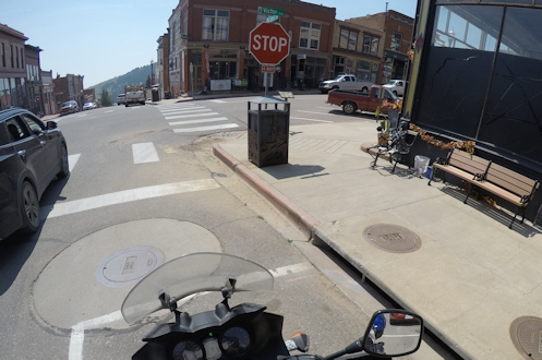
That place across the street, just to the right of the stop sign, is where we intended to eat. But no dice on this ride.

As I have remarked previously, I’ve seen yellow leaves before, so going for a fall color ride for me is more about the riding than the color. But if it’s a really nice show of color I certainly appreciate it. Well, apparently the place to go for color this fall was the southern part of Colorado, not the northern part.

Last week the RMMRC did one more fall color ride, this time down to Victor and Cripple Creek. It was a much smaller (seven) and therefore more comfortable group that headed south from Lincoln Avenue down Daniels Park Road, over to Sedalia, and down CO 105 to Monument and then I-25 into Colorado Springs.

We stopped just before turning onto US 24 to shed some layers, though it seemed odd to be taking layers off just as we were about to climb. But I did take off my sweatshirt knowing I could always turn on my electric vest if I needed to. I needed to, and as the temperature dropped as we climbed I soon wished I had left the sweatshirt on. Follow your instincts, not the crowd.

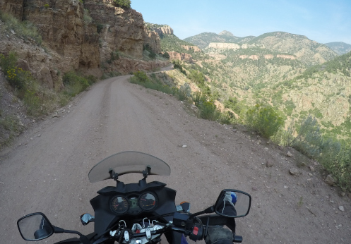
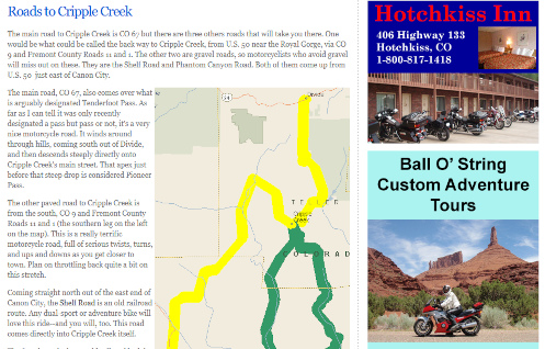
We took US 24 to Divide and turned south on CO 67, but took the fork to the left toward Victor (Teller County Road 821) rather than going into Cripple Creek. The plan was to have lunch in Victor. However, we got to the intended restaurant only to find it closed. This was the second Wednesday in a row that we got somewhere for lunch and found the restaurant closed. Note to all: Any time you plan a lunch ride, call the restaurant first to make sure they’re going to be open.

Meanwhile, backing up, the fall colors along CO 67 were by far the best I’ve seen all year. This is where you needed to go to see fall color. It was definitely beautiful. An unexpected treat.

In the middle of the week there apparently are not very many restaurants open in Victor so we had little choice but to cruise on over to Cripple Creek. But I wondered because I’ve been in Cripple Creek quite a few times and I’ve never identified any particularly good places to eat, unless you want to do some fine dining place in the evening and pay $40 or more for your meal–not what we look for in a lunch stop.

We did see one place, however, that looked like it might be good so that’s where we headed. Funny thing: I can’t remember the name of the place and I stroll down the street on Google Earth and the images are all old, there’s a lot of construction going on, and I can’t find the place. Sorry, I’d like to recommend it because I ordered a pulled pork sandwich and it was one of the best I’ve ever had. Also, Tom ordered an avocado toast and said it was exceptional. It’s on the north side of the street, at the western part of where the street is elevated on one side. If you’ve been to Cripple Creek you know what I mean.

Gearing up before leaving Cripple Creek I was putting my sweatshirt back on and mentioned to Roy how I had thought it odd to remove layers before going up. He said he had that same thought and he did not take anything off. Yeah. Follow your instincts, not the crowd.

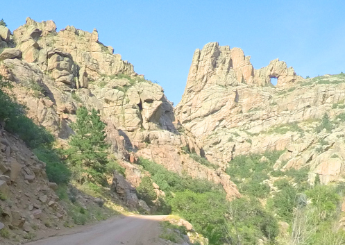
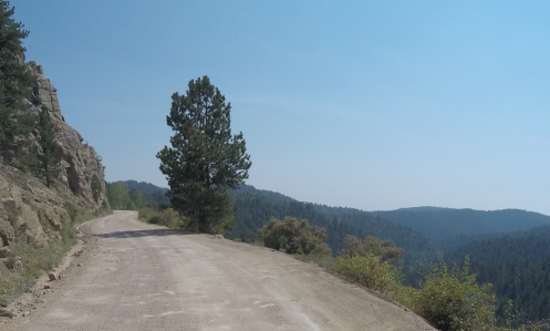
We headed straight up to Divide, then east to Woodland Park and then turned north on CO 67 up toward Deckers. Heading toward Divide the sky to the north was starting to look ugly. But where we were it was blue sky and sunshine. OK, enjoy it while you’ve got it.

Heading north out of Woodland Park rain was threatening and soon it was falling. But we rode through it for about a minute and came out on the other side and once again it was blue sky and sunshine. Nice. Up through Deckers and Buffalo Creek to US 285 at Pine Junction and we turned east. Oh boy. Now off to the east the sky didn’t just look threatening, it was black. But there was one spot of lightness on the horizon right exactly where I knew we were headed and I’ll be danged if our luck didn’t hold.

We got all the way to Denver, and I crossed the city on US 285/Hampden and just as I crossed I-25, now two miles from home, it finally started to rain. But even that stopped before I covered those two miles. What a nice day to be out riding! Maybe one of the last really good days we’re going to have for a while.

Biker Quote for Today

If motorcycle riding were a job, I would be the most hardworking employee.

More Dirt Around Cripple Creek

Thursday, September 16th, 2021
motorcycle on narrow mountain road

The Shelf Road is rougher but more scenic than Phantom Canyon Road.

I came down to Canon City from Victor on the Phantom Canyon Road. Now my plan was to go back up to Cripple Creek on the Shelf Road. This was part of an all-day dirt-riding run I did on my own. My thinking was that maybe this would be a good ride to lead some of the RMMRC folks on, those with dirt-capable bikes at least.

I headed north out of Canon City on Field Avenue, which became Garden Park Road. I was surprised, actually, at how far the road is paved. I guess I hadn’t been on this road in a lot of years. It does ultimately become the Shelf Road and the pavement ends.

This is one snaking road. And it is much narrower than the Phantom Canyon Road that I rode down to Canon City on. It’s also a lot rougher–a lot more potholes, bumps, and just generally uneven, loose gravel. I was glad I rode Phantom Canyon first because that allowed me to get back up to speed with my dirt-riding skills, such as they are.

One thing that was good about both roads is that there was not much traffic on either. That doesn’t mean I didn’t have my close call with oncoming traffic. You’re basically riding on a shelf cut into the hillside with a sheer drop on the other side and the turns are often very tight. So of course some guy is coming the other direction, around a spot where the road juts way out, and he wants to get a better view. So he drives right out to the edge, which is to say, directly into my traffic lane. Dude, did you not understand that it’s a blind curve? What if someone is coming the other way? And I was. I hit the brakes as hard as I dared and he very sheepishly quickly swerved back into his own lane.

The road from Canon City to Cripple Creek was only about 26 miles, compared to the 34 miles of the Phantom Canyon Road, but there had to be 10 times as many bumps. I had forgotten one thing I knew about riding dirt, which was to stand up on the pegs on the rougher stuff. Of course, on the Shelf Road that would have meant standing up most of the way. I paid for this the next day–my back really hurt! Fortunately it felt fine by the following day.

So the Shelf Road is probably the more scenic of the two. There’s even a spot where you see a natural arch or hole in the wall.

There’s a hole in the rock wall at upper right.

I got to Cripple Creek and was headed home but my dirt riding for the day was not quite over. I had seen on the map that as I headed north on CO 67 to Divide that there is a road a bit to the west that covers much of that same distance. This is Teller County Road 61. It diverges from and then rejoins 67 as they go north. Perhaps, I thought, this road would go through some unexpected beautiful spots, through some canyon maybe. So I took it.

Sorry to say, no, it’s just a dirt road through the woods. Oh well, I wasn’t going to be satisfied until I had seen it. Now I’ve seen it.

It was getting late and I was heading home and I had considered taking US 24 all the way into Colorado Springs and blasting to Denver on the interstate, or at least part of the way. But by now I would have been hitting the commuter traffic. You wouldn’t believe how many people commute between Denver and Colorado Springs for work. It’s ugly.

So I changed my mind and went back the way I came down, going up CO 67 and CO 126 north out of Woodland Park, back to US 285 and then home. That turned out to be a great choice. There was hardly another vehicle on the road; I had it all to myself. And let’s just say that I didn’t dawdle. It was a fun ride. In fact, the whole day was a fun ride. And I even got home in time for dinner (barely).

Biker Quote for Today

You know you’re a biker if one of your children or pets have either “Harley” or “Davidson” in their name.

Off The Pavement Outside Cripple Creek

Monday, September 13th, 2021
Phantom Canyon Road

This is actually one of the wider spots along the Phantom Canyon Road–and notice how smooth it is, at least now.

Most of this website was built more than a few years ago now but it’s never really finished. There is always stuff that needs to be updated and there are always roads I want to pay more attention to. And more and more those roads are unpaved. I mean, let’s face it, I’ve already addressed most of the paved roads in the state that are worthy of attention, but there are lots of unpaved roads, and some of them are fabulous.

One area that has had my attention lately is the area around Cripple Creek. Unlike the pages I’ve built for passes and for canyons, the page I envision for Cripple Creek would focus on all the roads leading to it. Because there are quite a few of them. And there’s not a one of them that’s not interesting or worth riding. But they’re not all paved.

With all this in mind, I headed out last week by myself to refamiliarize myself and to shoot photos to go on this new page. It turned out to be a longer day than I had anticipated, but man did I have a good time.

I headed out of Denver on US 285 as far as the turn-off at Pine Junction, going south on CO 126 through Pine and down to Deckers, where the road becomes CO 67. Up to this point, amazingly, it had been cool enough that I wore a down vest over my t-shirt inside my mesh jacket. I stopped at Deckers to use the john and stretch my legs and I took the vest off now.

CO 67 continues south from Deckers until it reaches Woodland Park and there I turned west on US 24. This took me the short distance to Divide, where I turned south once again on CO 67. Actually, it was CO 67 all the way; US 24 and CO 67 are the same along this stretch.

Heading south on CO 67 is the main road into Cripple Creek and all by itself it is quite scenic. The road rides high and there are numerous view points with nice scenery. And to top it off, as you crest the hill and descend steeply into Cripple Creek you have just gone over Tenderfoot Pass. Not that it’s well marked or anything, but it’s there.

But I didn’t go that route. Just a few miles before Cripple Creek CO 67 does a hard right but if you go straight you’ll be on Teller County Road 81, which goes to Victor. I don’t know why but I’ve always had the idea this road was unpaved, but it isn’t. It’s paved all the way. And, of course, the paved road goes on around to Cripple Creek so it’s a loop.

Victor was where I was to pick up the first of the day’s gravel roads: the Phantom Canyon Road. Coming this direction you actually come to the Phantom Canyon Road before you even get into Victor. I saw the sign for County Road 86 and thought that might be it but went on into town before I stopped to check the map. Sure enough. No matter, it wasn’t more than half a mile.

So I turned down County Road 86 and I had a little trepidation. The truth is, although I’ve had this V-Strom for a number of years now, and I got it specifically to be able to ride off the pavement, I just haven’t done all that much of it. Certainly not as much as I have wanted to do. And at this point, what dirt-riding skills I have developed were a bit rusty.

Not to worry. The road was amazingly smooth. So smooth, in fact, that it appeared it had only recently been graded. That impression was confirmed in a short while when I encountered the road grader at work.

The Phantom Canyon Road used to be a narrow-gauge train route so there were a couple tunnels cut through sheer rock walls and a lot of the road hugs the cliff with canyon way down below–and of course no guard rails and not so wide that two cars can pass comfortably unless one hangs back in wider spot when they see the other one coming. Absolutely fine for motorcycles, though.

Altogether, from Victor to where you hit US 50 east of Canon City it’s about 34 miles. It’s slow going so figure on an hour minimum. And it really is a pretty good road all the way, especially right now. You won’t be disappointed in the scenery.

I stopped in Canon City for lunch and that’s where I’ll leave this today. I’ll pick up the tale next time.

Biker Quote for Today

Why motorcycles are better than women: If your Motorcycle is too soft, you can get different shocks.

‘Roads To Cripple Creek’ Added To Website

Thursday, April 22nd, 2021

A portion of the new Roads to Cripple Creek page on the Passes and Canyons website.

For the first time in quite a while I have added a new page to the Passes and Canyons: Motorcycle Touring in Colorado website. The new page focuses on the numerous good motorcycle roads that lead to Cripple Creek, and I have named it “Roads to Cripple Creek.”

I don’t add many pages to the site these days because I’ve basically got it built out. It’s not like the roads in Colorado change all that often. I did add a new page for Guanella Pass when they finally paved that road all the way. But that’s not a common occurrence.

I first started thinking about Cripple Creek when I read somewhere that the high point of the road coming into town from the north, from Divide, is considered Tenderfoot Pass. If it’s a pass, I figured, I ought to have it on the site. But it’s kind of iffy as a pass. There is some more or less official registry of geographic place names in the U.S. and Tenderfoot Pass is not included on this list. And as many times as I have been over that road I never thought of it as a pass.

But then I got to thinking. While the road out of the north does have some good twists and turns, and goes up and down, and has some terrific views in places, it’s really probably not the nicest motorcycle road to get to Cripple Creek. There are others I would rate higher. So how about a page focusing on all of them. That’s what I did.

The other paved road into town is generally considered the back way, coming up in a roundabout manner from U.S. 50 a bit to the west of the Royal Gorge. If you’ve never been on this road you really need to do it. It has some terrific twists and lots of changes in elevation. Definitely better than the main road.

Then there are two gravel roads, both along old railroad beds. One comes directly into Cripple Creek, and that’s the Shelf Road, which comes north out of Canon City. Then the Phantom Canyon Road comes north from U.S. 50 a little to the east of Canon City and runs up to Victor, which is just a few miles east of Cripple Creek. Both of these are really nice, scenic road and are ride-able on street bikes as long as your bike is OK on decent gravel. For instance, I would not hesitate to take my Honda CB750 on them, but I would never consider riding them on my Kawasaki Concours. And of course, my Suzuki V-Strom loves that kind of stuff.

The page is not yet complete; I still need to add photos of these four roads. I have some already and just need to add them. For the others I’m going to have to go ride these roads again and get some shots. Oh the horrible burdens I bear!

Biker Quote for Today

The ride keeps me sane. I would like to call it my church.