Posts Tagged ‘Phantom Canyon road’

Route For A Five-Night Colorado Ride

Monday, March 18th, 2024

It’s pretty dang hard to beat motorcycle riding in Colorado.

Over the years I have received numerous requests from folks coming to Colorado to ride, asking me for recommendations on a route. I’m always happy to oblige and each one is different, with different parameters of what they want, how long they have . . . that kind of stuff.

The most recent is from Kevin in Indiana. He said he and a buddy have ridden many of the unpaved passes throughout the state by now they want to come on street bikes with their wives and do the pavement. Rather than the hub and spoke riding they have done out of Frisco and Crested Butte, Kevin asked for “an epic continuous trip” for his buddy’s 60th birthday.

Here’s what I sent him.

OK Kevin, I have something mapped out. A couple days are a bit over 250 but under 300. Obviously you can make any changes you see fit.

Figuring on you starting in Denver you can go north to Loveland, up the Big Thompson Canyon to Estes Park, over Trail Ridge Road to Granby and then take US 40 on to Kremmling for the night. This is shorter than 250 but with Trail Ridge Road you’ll definitely want to be making stops. You will need to make a reservation to get into Rocky Mountain National Park. The less busy entrance is the Fall River Road entrance. Park entrance differs if you want to see the park or just go through. I believe they allow people passing through in without reservations both early and late. You’ll see plenty of the park just going through. If you don’t make a reservation you might want to spend the night in Estes so you’ll be right there to go through early. That’s what my wife and I did last year.

(As an alternative to Loveland and the Big Thompson you could go up any number of passes to the Peak-to-Peak Highway and take it north to Estes.)

From Kremmling take US 40 west a bit further and turn onto CO 134 over Gore Pass. At Toponas go south to Wolcott and I-70, then east to the Minturn exit and take Tennessee Pass to Leadville, then a bit further south to Twin Lakes and go over Independence Pass through Aspen and down to Carbondale. From Carbondale take CO 133 over McClure Pass down to Hotchkiss for the night.

From Hotchkiss go west on CO 133 to CO 65 through Cedaredge and over the Grand Mesa. When the road forks north of Mesa stay on 65 (left fork) on to I-70. Take I-70 to Fruita then take the road south through Colorado National Monument, on Rim Rock Drive. Exiting the south end of the monument find your way to US 50 south and go maybe 8 miles to Whitewater. Take CO 141 west toward Gateway, then south to Telluride. This is the Unaweep Tabeguache Scenic Byway. Spend the night in Telluride.

From Telluride go over Lizard Head Pass down to Cortez, US 160 east to Durango, then US 550 north over Red Mountain Pass (the Million Dollar Highway) to Montrose, then east on US 50 to Gunnison. Overnight in Gunnison.

From Gunnison, run back a few miles to the Blue Mesa Reservoir and turn south on CO 149 through Lake City over Slumgullion Pass, through Creede and down to South Fork. Take US 160 west over Wolf Creek Pass to Pagosa Springs, then turn south on US 84 down into New Mexico to Chama. Go northeast from Chama over Cumbres and La Manga Passes on CO 17 up to Antonito, then US 285 north to Alamosa. Spend the night in Alamosa.

From Alamosa you have several options to get back to Denver. You can just take CO 17 north to pick up US 285 and follow that all the way to Denver. Or you can take US 160 east over La Veta Pass to Walsenburg, then go right back west and north out of Walsenburg on CO 69 to Westcliffe, then east on CO 96 on to Pueblo or up to Florence, to Penrose, and on to Colorado Springs.Or make your way to Canon City and then, because you guys are comfortable on gravel, take Phantom Canyon Road (CR 67) up to Cripple Creek, CR 61 up to Divide, pick up US 24, and take that to Woodland Park. At Woodland Park you can either continue on US 24 to Colorado Springs or go north on CO 67 through Deckers to Pine to US 285 southwest of Conifer. Then take 285 on into Denver.

This would be a heck of a good ride. Pick and choose what you like.

Besides being a nice guy and mapping this out for Kevin and his crew, I’ve done myself a favor here. First off, I got this blog post out of it. At this time of year it is harder than during the summer to keep coming up with blog ideas. But I may make it a triple. I figure this might well be a good basis for planning the 2025 OFMC trip. The 2024 trip is already planned but I might incorporate a lot of this for 2025. Also, I’ve been thinking for a long time about putting a ride together for the RMMRC. This might also go a long way toward that plan. We’ll just have to see what develops.

Biker Quote for Today

You might be a Yuppie biker if your only scoot has been a Knucklehead & you don’t even know what that is.
Off The Pavement Outside Cripple Creek

Monday, September 13th, 2021
Phantom Canyon Road

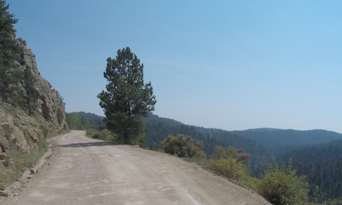
This is actually one of the wider spots along the Phantom Canyon Road–and notice how smooth it is, at least now.

Most of this website was built more than a few years ago now but it’s never really finished. There is always stuff that needs to be updated and there are always roads I want to pay more attention to. And more and more those roads are unpaved. I mean, let’s face it, I’ve already addressed most of the paved roads in the state that are worthy of attention, but there are lots of unpaved roads, and some of them are fabulous.

One area that has had my attention lately is the area around Cripple Creek. Unlike the pages I’ve built for passes and for canyons, the page I envision for Cripple Creek would focus on all the roads leading to it. Because there are quite a few of them. And there’s not a one of them that’s not interesting or worth riding. But they’re not all paved.

With all this in mind, I headed out last week by myself to refamiliarize myself and to shoot photos to go on this new page. It turned out to be a longer day than I had anticipated, but man did I have a good time.

I headed out of Denver on US 285 as far as the turn-off at Pine Junction, going south on CO 126 through Pine and down to Deckers, where the road becomes CO 67. Up to this point, amazingly, it had been cool enough that I wore a down vest over my t-shirt inside my mesh jacket. I stopped at Deckers to use the john and stretch my legs and I took the vest off now.

CO 67 continues south from Deckers until it reaches Woodland Park and there I turned west on US 24. This took me the short distance to Divide, where I turned south once again on CO 67. Actually, it was CO 67 all the way; US 24 and CO 67 are the same along this stretch.

Heading south on CO 67 is the main road into Cripple Creek and all by itself it is quite scenic. The road rides high and there are numerous view points with nice scenery. And to top it off, as you crest the hill and descend steeply into Cripple Creek you have just gone over Tenderfoot Pass. Not that it’s well marked or anything, but it’s there.

But I didn’t go that route. Just a few miles before Cripple Creek CO 67 does a hard right but if you go straight you’ll be on Teller County Road 81, which goes to Victor. I don’t know why but I’ve always had the idea this road was unpaved, but it isn’t. It’s paved all the way. And, of course, the paved road goes on around to Cripple Creek so it’s a loop.

Victor was where I was to pick up the first of the day’s gravel roads: the Phantom Canyon Road. Coming this direction you actually come to the Phantom Canyon Road before you even get into Victor. I saw the sign for County Road 86 and thought that might be it but went on into town before I stopped to check the map. Sure enough. No matter, it wasn’t more than half a mile.

So I turned down County Road 86 and I had a little trepidation. The truth is, although I’ve had this V-Strom for a number of years now, and I got it specifically to be able to ride off the pavement, I just haven’t done all that much of it. Certainly not as much as I have wanted to do. And at this point, what dirt-riding skills I have developed were a bit rusty.

Not to worry. The road was amazingly smooth. So smooth, in fact, that it appeared it had only recently been graded. That impression was confirmed in a short while when I encountered the road grader at work.

The Phantom Canyon Road used to be a narrow-gauge train route so there were a couple tunnels cut through sheer rock walls and a lot of the road hugs the cliff with canyon way down below–and of course no guard rails and not so wide that two cars can pass comfortably unless one hangs back in wider spot when they see the other one coming. Absolutely fine for motorcycles, though.

Altogether, from Victor to where you hit US 50 east of Canon City it’s about 34 miles. It’s slow going so figure on an hour minimum. And it really is a pretty good road all the way, especially right now. You won’t be disappointed in the scenery.

I stopped in Canon City for lunch and that’s where I’ll leave this today. I’ll pick up the tale next time.

Biker Quote for Today

Why motorcycles are better than women: If your Motorcycle is too soft, you can get different shocks.

First Ride Up Phantom Canyon

Monday, July 29th, 2013
V-Strom On Phantom Canyon Road

The V-Strom on Phantom Canyon Road.

I’ve known about the Phantom Canyon road for years but had never been on it until Saturday. Chalk up one more first on the V-Strom.

There are two roads leading up from Canon City to the Cripple Creek/Victor area. One is the Shelf Road, which I have been on before, and the other is the Phantom Canyon road.

On the last night out of this year’s OFMC ride we stayed in Canon City. Brett and Randy got going early wanting to get home to Denver as quickly as possible. John was heading back to Montrose, and Dennis, Friggs, Bill, and I weren’t in such a hurry to get home and decided to get there via Cripple Creek. As John headed west, Dennis, Bill, and Friggs headed north, following the pavement. I headed east and then north on the gravel.

The Phantom Canyon road is an old narrow-gauge rail bed so it is narrow and twisty and goes through some gorgeous country. At first it was very smooth, the sort of thing a street bike could handle easily, but up close to Victor it got rougher, particularly where the water runs across the road and eats trenches. It was nothing the V-Strom couldn’t handle with ease but again, a street bike could have done it. In fact, as I went up the canyon I encountered several bikes going down. The first were two dirt bikes, so of course they were fine. Then there was Can-Am Spyder and two trikes. With three wheels they were fine. And then there was a couple on a Harley. I’m sure as long as they took it easy and picked their path along they did just fine, too.

The canyon is very tight with steep walls at first, opening out later into something a bit more spacious. While the road does not show any “improvements” over the basic rail bed there are a few bridges that are clearly much more recent. And there are a couple railroad tunnels that give you an idea just how small those old trains must have been, because they would have been tight for two bigger motorcycles passing in opposite directions. In fact, much of the road is one lane and while a car and a bike could pass, two cars could not have. My biggest concern was not the road surface so much as the thought that a car might come fast around a blind curve and we might have an encounter. But that didn’t happen. A few cars going the other way were moving a bit fast on the more open stretches but on the tight curves it seemed everyone recognized that taking it slow was mandatory.

So this was the third time on this trip that I took the gravel while the other guys stayed on the asphalt. That totally works for me. I’m not keen on riding in such a big group to start with, and the reason I bought this dual-sport bike was to go places I would never go on a bike before. My wishes are now coming true.

Biker Quote for Today

Where a motorcycle takes you is more important than where you take it.