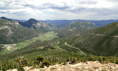
From an overlook on Trail Ridge Road.
You climb through the Big Thompson Canyon heading west out of Loveland with the river crashing down through this jagged granite gorge. Worthy of the ride all by itself, the canyon is just the appetizer as U.S. 34 continues through Estes Park and then the entrée is served: Trail Ridge Road.
Crossing Rocky Mountain National Park over the Continental Divide, Trail Ridge Road is the highest continuous motorway in the United States and a must-do ride for motorcyclists coming to Colorado. Reaching 12,183 feet at its highest point, the road stretches for more than 8 miles above 11,000 feet, well above timberline and offering spectacular views and its own brand of weather.
Warning to bikers: Do not dress for summer on this ride, even if it is blazing hot down lower where you’re starting out from.
You enter the park and loop around West Horseshoe Park, passing throngs of tourists with cameras blazing away at a flock of bighorn sheep. The sky is blue above but the dark, threatening clouds you’ve been eyeing all morning sit ominously to the south. Keep going.
But you can’t ride this road without stopping, so you pull over at several of the many turn-outs, especially Rainbow Curve, where the entire valley and the winding road you’ve just ridden are laid out below you. This is why you brought the camera.
The climb continues and then you’re above timberline, and two things demand your attention. First, the road is torn up for resurfacing, leaving loose sand and gravel in many places and just generally lousy road everywhere else. Second, the wind has picked up, that threatening cloud is now not far away at all, and the temperature has dropped about 20 degrees. Time for extra layers and gloves.
You loop along above timberline, through broad sweepers, up and down tundra-covered hills, and through a narrow notch cut through rock on one particularly steep curve. You’ve now passed the highest point in the road, and coming around a curve you descend a bit to the Alpine Visitor Center. Time to go inside, get warm, and have a bit of lunch.
Sitting in the restaurant at a table by a window you peer down the steep drop below you, watching a marmot scamper across a snowfield that never melts. Clouds the color of a nasty bruise now hang directly overhead and it would be raining except that it’s too cold to rain. Instead, tiny frozen raindrops tinkle against the window and ricochet off the rocks below you.
Forty-five minutes later the valley below you is completely obscured by clouds but overhead the sun is trying to poke through. You head back to the bike and pull out the rain gear because the road is now wet and there are still clouds to be wary of.
Down you ride, around Medicine Bow Curve, and then you parallel a canyon far below for several miles. Just over Milner Pass there is a crowd pulled over and there are elk with huge racks grazing and sparring. Time again for the camera.
From there the route is down, down, and down, and you exit the park. The town of Grand Lake glides by as do Shadow Mountain Lake and Lake Granby. U.S. 34 ends just west of the town of Granby, where it meets U.S. 40. From here its either west to Steamboat Springs or east over Berthoud Pass and back to Denver. East it is.
Biker Quote for Today
I ride because when everything in life is wrong it’s the only thing that’s right.
Tags: Trail Ridge Road