Summer Is Definitely Over

October 4th, 2021

Stopping on top of Wolf Creek Pass. Guess what? It was cold.

If there was one thing that became abundantly clear to me on this recent RMMRC Colorado Cruise was that if you are riding in the high country, summer is over.

I very foolishly wore my mesh jacket and I intended to find the liner but forgot it, and that was quite a mistake. Every time we got up high–which was frequently–I was cold because that cold air just cut through that mesh. That’s what they’re for, to give you nice ventilation on hot days. But these were not hot days. So why was I wearing mesh? Idiot.

I did finally think to use my rain jacket as a wind breaker and should have done so a lot sooner. Sometimes your brain works better than other times.

At the same time, it’s not cold yet down here on the prairie. Shortly after getting home I took the Honda out for a ride and, having gotten plenty chilled again and again on the last trip, I pulled on leather AND a sweatshirt, and for good measure, my winter gloves. Out I went and gosh, who coulda thunk it, I was way too hot. I mean, heck, it was all of 80 degrees or more. But my brain was still back on top of Cottonwood Pass and Red Mountain Pass and you know, you can never be too cautious.

Yes you can.

So here’s a little simple, very obvious advice. At this time of year, if you’re going up high, dress for cold. If you’re staying down low, and the temperature is above 75, expect warmth. How difficult is that? I don’t know, apparently for some of us (me) it’s not as simple as you might think. Maybe some day I’ll figure it out.

Biker Quote for Today

Why motorcycles are better than women: The rashes you get from motorcycles go away without those painful penicillin shots.

OFMC VS RMMRC

October 4th, 2021

The RMMRC heads down Independence Pass.

After five years riding with the Rocky Mountain Motorcycle Riders Club (RMMRC) I recently went on my first extended ride. All the others have just been day rides. Meanwhile, I’ve been going on week-long rides with the OFMC for more than 30 years. I figure a comparison of the two groups might be in order.

Some sharp contrasts come readily to mind. For one, the OFMC has gotten to be just one long ride and at best two day rides each year. Meanwhile, I can’t even count the number of rides I’ve been on with the RMMRC just this year. A lot. That’s why I joined the RMMRC.

Concern about safety is another sharp difference. To come on an RMMRC ride you must wear a helmet, and we always ride in staggered formation. In the OFMC no one is going to tell you you have to wear a helmet, although in later years none of us would even consider riding without one. The early years were a very different story.

As for staggered formation, the OFMC response to that would be “What’s that?” This had been a bit of an issue for awhile, with some of us lobbying for it while others responded with “don’t tell me how to ride.” I resolved the issue for myself by primarily riding sweep. Otherwise, I would try to make sure not to have Randy riding right behind me. Randy seemed to get target fixated on the rear tire of whoever was in front of him, and you’d check your mirror and there he was barely 25 feet right behind you. I was not grief-stricken when Randy chose to stop riding with us.

I have to say, though, that for awhile there was a guy like Randy in the RMMRC. And he was actually worse than Randy, a lot worse. It was suggested to me that maybe he had poor vision and that made sense. And maybe he had Lasik or cataract surgery because he no longer does that. What a relief.

Going on longer rides with the two groups has one very big difference. With the OFMC we know for sure how many will be coming and we divide motel reservations so each of us only needs to make one or two. Then we reserve rooms for the whole group. In the RMMRC it’s every man for himself. So if you’re going to be out for four nights, that’s four reservations each person has to make (unless you’re doubling up with someone else, which only a few people do). The difference here is probably that with the OFMC we’re friends outside of riding and I know that Bill or Dennis is not going to stiff me. With the RMMRC, these are people I see only for rides and with many of them I don’t even know their last names, much less where they live. Not that I would expect to get stiffed if someone decided at the last minute not to come, but it’s the difference between friends and folks you are friendly with.

One thing that seems to be true for both groups is that we mostly avoid talk of politics. There are people of differing opinions in both groups and there is no better way these days to tear a group apart than to get into pointless political arguments.

When it comes to hard riding, the RMMRC is definitely the high-miler club. There are members who are Iron Butt riders and it’s pretty much the norm to blast out 500 miles on the first day of a long ride in order to keep the days within the needs of people who have jobs. All OFMC riders are now retired and nobody is much into long days. A couple years ago I told the guys I could come up with a really nice route if they were willing to do a few long days. They said OK, and we had a nice ride, but afterward they told me they really don’t want to do long (350 miles in this case) days any more. Heck, with the RMMRC just recently we covered 400 miles going from Denver to Grand Junction via a wandering — and extremely scenic — route.

Inserted later: Now that points out one other important difference in the two groups. In the OFMC, if we get cold, we’ll stop and put on more gear. If our legs are getting stiff, we’ll stop and take a break. With the RMMRC it seems that once we get rolling we are going to continue rolling. These guys like to ride, not stop. Of course, with a group of any size, stopping requires time. One or two people can stop quickly and get going again, but with eight people it takes about four times as long. And you don’t cover lots of miles in a day if you’re stopping all the time.

Also, in later years the OFMC has decided we like to take it easy and have at least one non-riding day in the middle of the week. That has become our golf day. So we get to stay two nights in one spot and not have to pack up and head out every single day. I don’t think the RMMRC does anything like that. Maybe I’m wrong; I’ve only been on one long ride and that was just a four-day ride.

And then there’s this difference between the groups: the OFMC is and always has been just guys, while the RMMRC has women members. Not that it makes any noticeable difference.

Of course, the RMMRC has meetings and officers and all that. The OFMC is just a bunch of guys with motorcycles.

What else? That’s all I can think of right now. I enjoy riding with both and I’m glad I have both to ride with.

Biker Quote for Today

Sons of Alzheimer’s: Where’s my bike?

Over The Top And Scatter

September 30th, 2021

A gas stop on the ride.

There was no rush leaving Gunnison on our last day out. It was a short ride home and we might as well let it warm up a bit. Except for Mark, who slipped out on his own early, just wanting to get home.

Now that Cottonwood Pass has been paved all the way it makes a really good alternative to Monarch Pass. Not only is it shorter, there are still plenty of people who have never been over the new road yet. That was true of at least a couple of our folks so that was the obvious route.

Despite our later start it was still darn chilly heading up Taylor Canyon but oh boy was it beautiful in the morning light and there was almost no traffic. Just nice for a cruise. Still, the further we went, and the higher we went, the colder I got. Thank goodness I had my electric vest.

Just below Taylor Reservoir we stopped because Ralf again wanted to talk about hydro-geological issues. He pulled over right below the dam and talked about the Colorado River Compact. At this point the wind was whipping a good bit so it was very cold standing there. I had the idea to pull out my rain jacket to use as a windbreaker and as I turned back to my bike I saw that Susan had already had the same idea and was pulling on her rain jacket. That made a lot of difference and I kicked myself for not thinking of this a couple days earlier.

We continued on past the reservoir and up the pass. The new road is very nice but I still miss some of the twisting and turning that they straightened out when they redid this road. I guess that’s what they call “progress.”

We stopped at the top and this was in fact our time for good-byes. Heading on down, Susan planned to make a stop in Buena Vista, Ralf was going to be heading down toward Salida, and Charley and Karen had no intention of trying to keep up with the fast guys–Bob and Dave–on US 285 on their double-loaded 650 BMW scooter. That left Bruce and me to play it how we saw it.

Down to Buena Vista, to US 24, to US 285, and east. At first the four of us were together but it didn’t take long for traffic to separate us. But then, thanks to passing lanes, we were back together. This continued until we reached Fairplay and then somewhere between Fairplay and Jefferson Bruce dropped off. Now it was just me, sort of trying to keep with Bob and Dave but not really expecting it to last.

But somehow I did stay with them all the way to Bailey. Making the bend and heading up Crow Hill I figured this would be where the final split occurred. We started up the hill together but soon cars had moved between us and that was the last of it. I would occasionally catch a glimpse of them up ahead but by the time I got to Conifer they were lost in the distance.

Not a problem. After four days in a group I was enjoying being on my own. Rain was threatening, and even dripping a little here and there, but it finally really came down around Conifer. I already had my rain jacket on so I just rode through it and sure enough, it stopped soon. Then on down the hill and into town.

Now of course, I was hot. There’s just no way to avoid hitting one extreme or the other when you’re on a motorcycle. So I got home as quickly as I could and eagerly peeled everything off. Ah! Time to relax. Good ride. Nice trip. Nice to be home.

Biker Quote for Today

100 reasons not to date a biker: 31. You’ll have to help us with bike projects, because sometimes it takes three hands.

A Cold, Early Ride

September 27th, 2021
The place where Butch and Sundance landed

The Animas River where it is crossed by Baker’s Bridge.

Red Mountain Pass was going to close for construction at 8:30 a.m. so we agreed to play it safe and leave Ouray at 7 a.m. You could call that an excess of caution, and Ralf did, saying he planned to leave at 8 and maybe we would still be in Silverton having breakfast when he got there. We were and he did.

This was day three of the Colorado Cruise, my first multi-day ride with the Rocky Mountain Motorcycle Riders Club (RMMRC).

It was not as cold in Ouray at 7 a.m. as we all expected but we were already at 7,800 feet and the top of Red Mountain Pass is 11,000 feet. I blessed myself for having brought my electric vest and cursed myself for not digging out the liner for my mesh jacket. It was somewhere at home.

We started up the pass and it got cold in a hurry. The sun was up somewhere but with the mountains we sure couldn’t see–or feel–it. By the time we got to the top my fingers were ice cubes and the rest of me was not far behind. I really couldn’t feel the warmth from my vest except I know that without it I would have been totally frozen. I anticipated warmer air as we descended.

But Silverton is still 9,300 feet up there so you can be excused for not noticing much more warmth. Finally we were coming to a bend where I could see sunshine but as we came around it we suddenly had the blazing sun, barely above the horizon, smack in our faces, almost totally blinding us. And then we were back in the shadows.

We got to Silverton and stopped first for gas. My tank bag on the V-Strom covers the gas cap and there are two clasps that need to be undone to access it. For a couple minutes my fingers were too numb to open the clasps. And then it was only with difficulty that I inserted the key to open the gas cap. Give me some coffee and some breakfast!

Not so easily done. Every restaurant in this country seems, at this time, to be short of staff. Posted hours mean nothing; they open when they open. We could find only one open restaurant in Silverton and they had a 90-minute wait. We settled for coffee and pastries at an open coffee shop. And Ralf showed up.

Back on the bikes, we headed toward Durango but Bob knew a better route. About 20 miles south of Silverton we turned off onto County Road 250, took a couple of sharp turns, and stopped at a bridge over a good-sized stream. This was Baker’s Bridge and Bob explained that it was the place where, in the movie “Butch Cassidy and the Sundance Kid,” Butch and Sundance landed after they jumped off a cliff into the river below. Now, it wasn’t where they jumped from, but this is a movie and they filmed the jumping somewhere and the landing somewhere else. This was the somewhere else.

We then stayed on 250 as it ran along the hillside of the valley leading down to Durango. Coming into Durango we turned onto North College Drive, still on the hill skirting the town, and finally coming out on CO 3 at the south end of town before getting onto US 160 eastbound. We totally missed all the mess and congestion that is Durango. What a great route! And it was very pretty, too.

So we headed east on US 160 over to Pagosa Springs. We stopped for lunch in Pagosa but again found it hard to find a nice restaurant that was open and didn’t have more than an hour to wait. Finally we just split up with some going to a nicer place and others going to fast food joint. And Charley and Karen went off to their daughter’s house.

We had agreed to meet up again on top of Wolf Creek Pass but that didn’t happen. Nobody was interested in waiting who knows how long at the top of the pass when they’d rather be riding. So our group rode on down to South Fork where we stopped for gas. Then we turned north on CO 149 up over Slumgullion and Spring Creek Passes. Starting down Slumgullion we caught up with some riders and — surprise! — they were part of our group. They had passed us while we were getting gas.

On through Lake City and down to the Blue Mesa Reservoir and to Gunnison. That was a long day’s ride. Good to reach the end.

Biker Quote for Today

You might be a Yuppie biker if you’re a HOG member and think you’re an outlaw.

On The Way To Ouray

September 23rd, 2021

Ralf discusses plate tectonics, uplift, and erosion in a place where you can really see the results.

Dave and I loaded up and rode across the street to join the rest of the RMMRC group on our four-day ride the second morning. While I parked, Dave disappeared. After a few minutes it occurred to me and I asked Susan if they had all already gotten gas. She said yes and I realized that was probably where Dave had gone. I figured I’d better do so, too.

I filled up and used the facilities one last time and as I came out I saw a group of bikers heading down Horizon Drive toward the westbound I-70 ramp and then realized it was my group. They were leaving without me. I guess I should have said something to someone other than Susan about getting gas.

I hopped on and blasted away to catch up but this is a fast group of riders so that didn’t happen at all quickly. Meanwhile I considered the situation. I recalled some discussion of riding Colorado National Monument. Our ultimate destination this day was Ouray so it would make the most sense if you’re going to ride the monument to start on the Fruita end. But they might not; could I get to the exit to the other end before I lose sight of anyone? Regardless, I figured if I didn’t find them I would ride the ride I considered nicest, which would be to go to Fruita, ride the monument, and then meet them all at lunch down in Gateway.

Just as I got to the exit to the non-Fruita entrance to the monument I caught a glimpse of riders ahead on the interstate so I figured that was them and I cranked the throttle even harder. Just as they were exiting at Fruita I pulled up alongside Charley, who was riding sweep with his wife Karen on behind. Charley waved me on ahead of him and I was back with the group.

We rode the monument, stopping a couple times so Ralf, a hydro-geologist, could give us a little education on plate tectonics and uplift and erosion. Ralf is very knowledgeable so these were interesting presentations.

Leaving the monument we headed down US 50 to Whitewater, where we turned west on CO 141 toward Gateway and the Unaweep Tabeguache Scenic Byway. The Paradox Grille in Gateway is excellent, but also on our agenda was the Gateway Auto Museum. I’ve been to Gateway numerous times, eaten at the Paradox several times, but I had never been in the museum. Let me tell you it’s worth it. They have some amazing cars in there.

The road to Gateway is very nice but the road south from there to Naturita is spectacular. If you are familiar with the canyon country of Utah, this is a small area where the canyons crossed the state line and made their way into Colorado. Beautiful country and a beautiful ride.

We stayed on CO 145 until Placerville and then took CO 62 on to Ridgway. From there it’s just a few miles south on US 550 to Ouray. Coming into town we saw signs warning that 550 over Red Mountain Pass would be closed for construction beginning at 8:30 a.m. the next day. Oh, oh. We’re going to have to get an early start. And it’s going to be cold.

Biker Quote for Today

We know you’re a poser if you set at least one mirror, if not both, to reflect yourself.

400 Miles To Grand Junction

September 20th, 2021

One of the narrow spots on Independence Pass.

Who knew it was 400 miles to Grand Junction from Denver? Or that it would take more than nine hours? We all know shortcuts; here we’re talking about longcuts.

I took off a week and a half ago with eight others from the Rocky Mountain Motorcycle Riders Club (RMMRC) on a four-day Colorado Cruise ride and that was our first day. This is not a group that just rides out to the local bar; this is a group for people who really want to ride.

Nine of us on eight bikes left Morrison at 9 a.m., heading up along Bear Creek to Evergreen, cutting over toward I-70 on Evergreen Parkway, and then taking Jefferson County Road 65 from Bergen Park over to old US 40 alongside I-70, and finally down to where that road meets old US 6 coming up out of Clear Creek Canyon. Then we had no choice but to get on the interstate for a few miles.

We got off I-70 to go over Loveland Pass, down the other side and onto the Shadow Mountain Road to go around that reservoir, over to Frisco and back on the slab. Then off again at Copper Mountain to go up Fremont Pass to Leadville, where we stopped for lunch.

After lunch we headed down to Twin Lakes and turned up over Independence Pass. That brought us down to Carbondale but no way were we interested in continuing to Glenwood Springs on I-70; we turned south and went up over McClure Pass and down to Paonia. That put us on CO 92 heading west but at the tiny town of Austin we took a shortcut north to connect with CO 65 at Orchard City, on through Cedaredge and over the Grand Mesa.

Our day was getting long at this point but the folks in the lead are go-fast guys and there was no traffic so we probably crossed the Grand Mesa in record time, coming on down finally to I-70 and blasting on into Grand Junction as the rain started falling. Just as we reached the shelter of the motel entryway the skies opened up briefly and then we had a terrific rainbow.

And that’s how you cover 400 miles on a trip the map says is about 250 miles. Our ride was a lot prettier than the interstate, a lot more twisty, and we got up high where the leaves were already turning. A beautiful day to ride. A very auspicious start to the trip.

Biker Quote for Today

You know you’re a biker if you buy your 3-year old niece a Harley-Davidson t-shirt.

More Dirt Around Cripple Creek

September 16th, 2021
motorcycle on narrow mountain road

The Shelf Road is rougher but more scenic than Phantom Canyon Road.

I came down to Canon City from Victor on the Phantom Canyon Road. Now my plan was to go back up to Cripple Creek on the Shelf Road. This was part of an all-day dirt-riding run I did on my own. My thinking was that maybe this would be a good ride to lead some of the RMMRC folks on, those with dirt-capable bikes at least.

I headed north out of Canon City on Field Avenue, which became Garden Park Road. I was surprised, actually, at how far the road is paved. I guess I hadn’t been on this road in a lot of years. It does ultimately become the Shelf Road and the pavement ends.

This is one snaking road. And it is much narrower than the Phantom Canyon Road that I rode down to Canon City on. It’s also a lot rougher–a lot more potholes, bumps, and just generally uneven, loose gravel. I was glad I rode Phantom Canyon first because that allowed me to get back up to speed with my dirt-riding skills, such as they are.

One thing that was good about both roads is that there was not much traffic on either. That doesn’t mean I didn’t have my close call with oncoming traffic. You’re basically riding on a shelf cut into the hillside with a sheer drop on the other side and the turns are often very tight. So of course some guy is coming the other direction, around a spot where the road juts way out, and he wants to get a better view. So he drives right out to the edge, which is to say, directly into my traffic lane. Dude, did you not understand that it’s a blind curve? What if someone is coming the other way? And I was. I hit the brakes as hard as I dared and he very sheepishly quickly swerved back into his own lane.

The road from Canon City to Cripple Creek was only about 26 miles, compared to the 34 miles of the Phantom Canyon Road, but there had to be 10 times as many bumps. I had forgotten one thing I knew about riding dirt, which was to stand up on the pegs on the rougher stuff. Of course, on the Shelf Road that would have meant standing up most of the way. I paid for this the next day–my back really hurt! Fortunately it felt fine by the following day.

So the Shelf Road is probably the more scenic of the two. There’s even a spot where you see a natural arch or hole in the wall.

There’s a hole in the rock wall at upper right.

I got to Cripple Creek and was headed home but my dirt riding for the day was not quite over. I had seen on the map that as I headed north on CO 67 to Divide that there is a road a bit to the west that covers much of that same distance. This is Teller County Road 61. It diverges from and then rejoins 67 as they go north. Perhaps, I thought, this road would go through some unexpected beautiful spots, through some canyon maybe. So I took it.

Sorry to say, no, it’s just a dirt road through the woods. Oh well, I wasn’t going to be satisfied until I had seen it. Now I’ve seen it.

It was getting late and I was heading home and I had considered taking US 24 all the way into Colorado Springs and blasting to Denver on the interstate, or at least part of the way. But by now I would have been hitting the commuter traffic. You wouldn’t believe how many people commute between Denver and Colorado Springs for work. It’s ugly.

So I changed my mind and went back the way I came down, going up CO 67 and CO 126 north out of Woodland Park, back to US 285 and then home. That turned out to be a great choice. There was hardly another vehicle on the road; I had it all to myself. And let’s just say that I didn’t dawdle. It was a fun ride. In fact, the whole day was a fun ride. And I even got home in time for dinner (barely).

Biker Quote for Today

You know you’re a biker if one of your children or pets have either “Harley” or “Davidson” in their name.

Off The Pavement Outside Cripple Creek

September 13th, 2021
Phantom Canyon Road

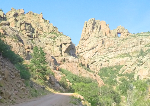
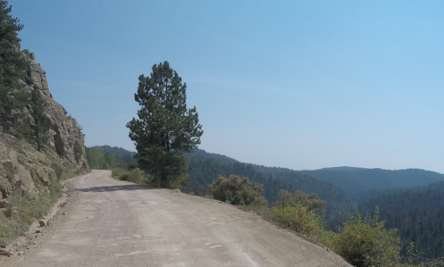
This is actually one of the wider spots along the Phantom Canyon Road–and notice how smooth it is, at least now.

Most of this website was built more than a few years ago now but it’s never really finished. There is always stuff that needs to be updated and there are always roads I want to pay more attention to. And more and more those roads are unpaved. I mean, let’s face it, I’ve already addressed most of the paved roads in the state that are worthy of attention, but there are lots of unpaved roads, and some of them are fabulous.

One area that has had my attention lately is the area around Cripple Creek. Unlike the pages I’ve built for passes and for canyons, the page I envision for Cripple Creek would focus on all the roads leading to it. Because there are quite a few of them. And there’s not a one of them that’s not interesting or worth riding. But they’re not all paved.

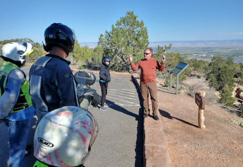
With all this in mind, I headed out last week by myself to refamiliarize myself and to shoot photos to go on this new page. It turned out to be a longer day than I had anticipated, but man did I have a good time.

I headed out of Denver on US 285 as far as the turn-off at Pine Junction, going south on CO 126 through Pine and down to Deckers, where the road becomes CO 67. Up to this point, amazingly, it had been cool enough that I wore a down vest over my t-shirt inside my mesh jacket. I stopped at Deckers to use the john and stretch my legs and I took the vest off now.

CO 67 continues south from Deckers until it reaches Woodland Park and there I turned west on US 24. This took me the short distance to Divide, where I turned south once again on CO 67. Actually, it was CO 67 all the way; US 24 and CO 67 are the same along this stretch.

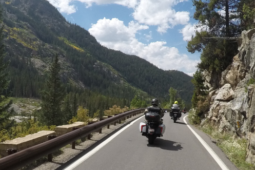
Heading south on CO 67 is the main road into Cripple Creek and all by itself it is quite scenic. The road rides high and there are numerous view points with nice scenery. And to top it off, as you crest the hill and descend steeply into Cripple Creek you have just gone over Tenderfoot Pass. Not that it’s well marked or anything, but it’s there.

But I didn’t go that route. Just a few miles before Cripple Creek CO 67 does a hard right but if you go straight you’ll be on Teller County Road 81, which goes to Victor. I don’t know why but I’ve always had the idea this road was unpaved, but it isn’t. It’s paved all the way. And, of course, the paved road goes on around to Cripple Creek so it’s a loop.

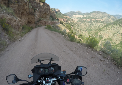
Victor was where I was to pick up the first of the day’s gravel roads: the Phantom Canyon Road. Coming this direction you actually come to the Phantom Canyon Road before you even get into Victor. I saw the sign for County Road 86 and thought that might be it but went on into town before I stopped to check the map. Sure enough. No matter, it wasn’t more than half a mile.

So I turned down County Road 86 and I had a little trepidation. The truth is, although I’ve had this V-Strom for a number of years now, and I got it specifically to be able to ride off the pavement, I just haven’t done all that much of it. Certainly not as much as I have wanted to do. And at this point, what dirt-riding skills I have developed were a bit rusty.

Not to worry. The road was amazingly smooth. So smooth, in fact, that it appeared it had only recently been graded. That impression was confirmed in a short while when I encountered the road grader at work.

The Phantom Canyon Road used to be a narrow-gauge train route so there were a couple tunnels cut through sheer rock walls and a lot of the road hugs the cliff with canyon way down below–and of course no guard rails and not so wide that two cars can pass comfortably unless one hangs back in wider spot when they see the other one coming. Absolutely fine for motorcycles, though.

Altogether, from Victor to where you hit US 50 east of Canon City it’s about 34 miles. It’s slow going so figure on an hour minimum. And it really is a pretty good road all the way, especially right now. You won’t be disappointed in the scenery.

I stopped in Canon City for lunch and that’s where I’ll leave this today. I’ll pick up the tale next time.

Biker Quote for Today

Why motorcycles are better than women: If your Motorcycle is too soft, you can get different shocks.