Recap: Steve and some buddies are coming from New Zealand in 2009 for some motorcycle touring in Colorado and Utah. This series of posts lays out their proposed routes, with my comments. Your comments are welcome as well.
Day 2
All right, today we’re in for some riding. The proposed route covers about 350 miles, and brings the group back to Gunnison for a second night. This is a good choice of roads and I have no alternatives to suggest. Here’s the map. Click the link to see the map in larger size.
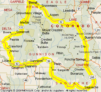
The day starts heading west out of Gunnison on US 50. This soon runs alongside Blue Mesa Reservoir, which is the reservoir created by the dam above the Black Canyon of the Gunnison. At the dam, US 50 continues west but our group is heading northwest on CO 92. You cross the dam to get to the north side of the river and then cruise the twisty road running along the north rim of the Black Canyon. Be sure to stop and peer down into the canyon at some of the pull-outs.
Then the road leaves the canyon and heads north through Crawford. Now, Crawford is where rocker Joe Cocker lives, and his wife used to run a biker-friendly restaurant here, but that has closed. CO 92 meets CO 133 at Hotchkiss and a right turn takes you to Paonia and up over McClure Pass. One sidetrip you’ll definitely want to make once you get over the pass is to Marble. It’s not far and the road is paved. Check that McClure Pass link for more about Marble. You can easily spend a couple hours here, though, so that will add to the length of the day. But hey, it’s summer. There are a lot of daylight hours.
I also challenge you to pass the old coke ovens at Redstone without stopping. I’m sorry, this stuff is just too interesting.
Just past Carbondale, CO 133 meets CO 82. A left takes you down to Glenwood Springs, a right goes to Aspen. We’re heading to the right. For some people, Aspen itself would be the draw, but we’re on motorcycles so what really beckons is Independence Pass. This is one of the best in all of Colorado. In fact, that picture I use on the home page of motorcyclecolorado.com is taken along Independence Pass. It also closes for the winter and at the time Steve and crew are coming it will probably only have been open for a couple weeks. Here’s hoping no late spring blizzard delays the snowplows.
Independence Pass comes down at Twin Lakes and then joins US 24 a little further on. This is the road the group came in on the day before so from here they retrace their route down through Buena Vista to Poncha Springs. Having headed west yesterday from Poncha Springs over Monarch Pass, today the group will continue south on US 285. This road crosses Poncha Pass, which is a nice ride, but is not comparable to so many Colorado passes, which is why I don’t have a page about it on the website.
At Saguache they leave US 285 and pick up CO 114. This road connects with US 50 just east of Gunnison and the end of the day’s ride. In doing so, it crosses North Pass, which, like Poncha Pass, is a lovely ride but not as high or spectacular as so many Colorado passes. Still, it’s well worth the ride, especially if your other option is backtracking on roads you’ve already ridden.
So, at 350 miles, this is a pretty long ride in terms of hours, especially if you make stops at Marble and/or Redstone. For one thing, Independence Pass is very slow going, but you wouldn’t want to rush it anyway. It’s too spectacular. The highway along the rim of the Black Canyon is also slow going. Of course, passing through Aspen is going to slow you down. But it’s definitely doable, especially if you know you’ve got your night’s accommodations covered in advance. So ride. Ride a lot! Enjoy.