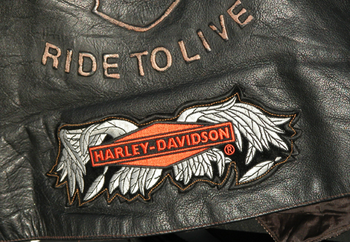
Randy Savely’s vest with the Broken Wings patch.
The broken wing patch says to the world after a bad wreck that you have what it takes to get right back on a bike and keep on living. – 6 Gun
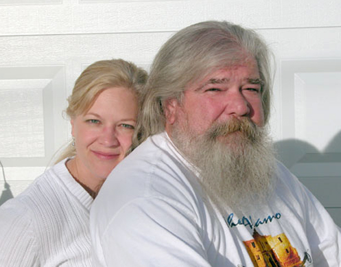
Back in the saddle
Randy Savely was without a motorcycle from March 2007, when his Harley was destroyed in the crash that cost him a leg, until September 2008, when his court case was concluded and he and Joan received a cash settlement. He had ridden a couple times already, however, on friends’ bikes.
The first ride was in the 2008 Commerce City Memorial Day parade. Joan was “beside myself” with fear for him but Randy had never wavered in his determination to ride again.
Coming down I-270 at the back of the group, Randy noticed that his left foot had fallen off the peg and was dragging. Not good. He hoisted his leg up and swung the prosthesis onto the peg and rode the rest of the way putting pressure on it to ensure it stayed put.
At last it was time for the Broken Wings patch. The patch is frequently given to a rider by another who has also crashed and gotten back on. Randy had received the patch before he rode, but it was only after this ride that he allowed Joan to sew the patch onto his vest.
The idea of riding behind him again was also a difficult issue for Joan.
“You’ve got to get a few miles on that bike before I ride with you,” she told him. “It was glorious and sobering. Do I really want to do this again?” she asked herself.
Still, by the time Randy had about 6 miles on the new bike Joan hopped right on.
“It felt totally safe, more so than on the old bike,” she says, unable to explain it. “Maybe it’s the law of averages.” After all, how many people suffer two major crashes?
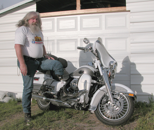
The new Harley Ultra Classic has a number of customizations designed to compensate for Randy’s limitations. First off, it has floorboards with a stirrup on the left to keep his foot from falling off again. It also has an electric shift. Buying a new pair of boots recently, Randy found he couldn’t operate the kick-stand wearing them so now he plans to get an electrically operated one.
Backing up is a struggle, especially on loose gravel.
“I plant my foot real good and push back. Backing is the hardest thing to do.”
Randy mounts from the right side so he can lift his left leg over. Weakness in the left leg makes it impossible to stand on that leg and lift the right leg over. It can be a significant problem getting on when someone parks too close to him on the right side.
Randy’s accident has also had an effect on other riders he knows. One friend’s wife made him sell his bike. Joan’s son Vince, for whom Randy has been dad since he was 9, left his bike unridden and unlicensed for more than a year after the accident. He has finally started riding again, however.
It has been a hard two years but Randy and Joan are upbeat.
Says Joan, “It will never be the way it used to be, but now, two years later, it’s pretty darn good. It’s all relative for us. We had to make a choice: give up and let it beat us or keep fighting.”
“It’s as normal as what a person can make of it,” says Randy. “Yes, it does hurt, it hurts every day, and it’s always a struggle trying to do something with it.”
Some people are hesitant to bring up the issue but Randy laughs that off.
“I know I lost my leg, it’s no secret to me.”
And there have been mishaps. Randy and Joan went dancing one night and all that movement loosened the prosthesis. As they walked out the door of the bar his leg fell off.
“We laughed pretty hard at that, and at a lot of things. You have to.”
Through it all the most important thing has been the support they have received from so many people.
“We didn’t expect any of it,” says Joan. “There’s never a way to pay that back, so we decided to pass it on and do at some other level for other people. Pay it forward, call it whatever you like.”
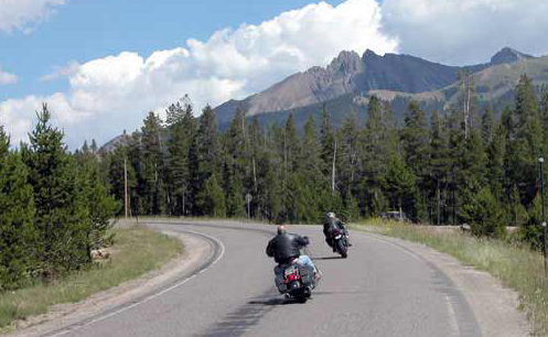
That’s where the Randy Run comes in.
The Randy Run
Randy and Joan were financially devastated by the accident, losing their house and most of what they had. But seemingly out of nowhere a community of friends–as well as total strangers–gathered around them to provide support and caring and to ensure that they did not sink into despair and isolation.
While Randy was still in the hospital, one friend had the idea of organizing a fundraising run to raise money to help out. Dubbed the Randy Run, Joan’s friend Deb Anderson took charge of organizing it, going so far as joining ABATE in order for it to be an official ABATE District 10 run, although Deb does not ride.
Deb and her boyfriend were “absolutely my lifeline that kept me square,” says Joan. “The Randy Run evolved out of her dedication–she didn’t know what else to do.” That first year, the money raised went to Randy and Joan.
The following year, Randy and Joan helped to organize a second Randy Run to benefit others who suffer severe injuries on their bikes. Now, in 2009, ABATE of Colorado has made the Randy Run a state-wide event, to be held annually. This year’s Randy Run is set for this Sunday, June 14, and Randy and Joan are heavily involved.
“The Randy Run is part of what has helped us get back,” says Randy. “The run is a reason for coming back.”
Joan adds, “It would have been easy to just quit, but the way people came together to help us, it humbles you and changes your perspective in a heartbeat.”
Randy bought patches for the two beneficiaries of last year’s Randy Run, but he’s still holding on to them because neither of those riders have yet gotten back on a bike.
Randy and Joan are back, however, and on Sunday they’ll be riding. You can bet I’ll be there, too.
Part 1 – The Accident and the Hospital
Part 2 – The Road to Recovery
The Randy Run for Fallen Bikers
Biker Quote for Today
Getting really old, had to get one of those mobility scooters.
—What kind?
—Harley-Davidson