This is another Examiner.com resurrection, dating from June 2009.
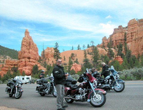
Riders taking a break at Red Canyon.
“Spectacular†is the word to describe the canyon country of southern Utah, and the best of it is completely accessible on a motorcycle. And no, I’m not talking dual sport. I mean Harley/Honda luxotourers.
Get here via whatever route suits you, we’re just going to cover Utah 12 and Utah 63, which goes down into Bryce Canyon National Park.
Heading east from the junction with U.S. 89, Utah 12 very quickly enters Red Canyon. Here you get just an inkling of what you’ll find at Bryce Canyon, but Red Canyon is incredibly beautiful all on its own.
Continue east until you reach the turn-off for Utah 63, which heads south a few miles before entering the national park. There are a couple motels just north of the park and they have restaurants that are open until 10 p.m. If you’re the camping sort, there are campgrounds inside the park, and back at Red Canyon as well.
The entrance fee for the park is $12 for motorcycles, unless you’re a grey-hair and have your Golden Age Pass.
We found the best thing to do was to run all the way to the end of the road without stopping and then make all your stops on the way back north. The reason is, all the view areas are on the east side and this lets you avoid pulling in and out across oncoming traffic. Of course, the entire road through the park is well-maintained asphalt.
Taking this approach, your first stop will be Rainbow Point. The view, on a clear day, is more than 100 miles. You’re at a towering height and it’s like the whole world is laid out at your feet.
Working your way back to the north, there are small, unnamed view areas and bigger, named view areas. Not surprisingly, the views are more spectacular at the named spots. That’s not to say the smaller spots are not worth stopping at.
The further north you get the most the view becomes one of towering, multi-colored hoodoos, as they’re called. These are the pinnacles that stand tall as the areas around them erode away. Not a true canyon, Bryce Canyon has been formed primarily by water seeping into cracks in the rock, freezing, and forcing the crack wider and wider, while the chips that break off get washed away.
Finally, back near the north end of the park, is the ring of view areas named Sunset, Sunrise, Inspiration, and Bryce Points. This is the best spot to get off the bikes and actually hike down into the canyon. The shortest loop, six-tenths of a mile, is Navajo Trail Loop. For a bit longer hike, take the Queen’s Garden trail from Sunset Point over to Sunrise Point, about 1.6 miles. There’s a lot of down and then a lot of up, so be sure to wear decent walking shoes and carry water. Don’t be surprised if it rains a bit while you’re walking, but usually the coolness and wet is welcome.
Then you’re on your way again. Panguitch, about 7 miles north of Utah 12 on U.S. 89 is a nice place to stop for the night, with numerous attractive motels, a grocery store, gas stations, and restaurants.
Enjoy the ride, but enjoy the stops, too.
Biker Quote for Today
I love to ride. I hate to arrive.
Tags: motorcycling in Utah