Archive for the ‘Day Rides’ Category

Stove Prairie Road a Good Ride, But Don’t Go Down

Monday, October 27th, 2008

An interesting news report about the Fort Collins Chief of Police. He was up on Stove Prairie Road and went down on his buddy’s Road King. He suffered a broken pelvis but got back on the bike and rode into town to the hospital.

“It was very apparent something was really wrong,” said Chief Dennis Harrison.

Yeah, I guess. Call me a wuss but I think I would have waited for the ambulance. Oh, and no mention about the condition of the bike.

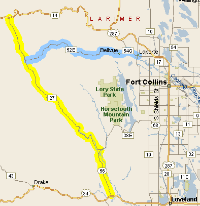
Stove Prairie RoadNo place is a good place to go down but Chief Harrison did pick a nice place to ride. I’ve been on that road many times and I strongly recommend it. What it is best is a way to avoid going through all the sprawl of Fort Collins when you’re on your way up the Poudre Canyon. The Stove Prairie Road runs over the ridge from the Buckhorn Canyon to the Poudre. Here’s a map showing the area.

What you do is head west out of Loveland on US 34, like you’re going up to Estes Park, except just a bit west of town, as you get past the hogback, you go north on CO 56 to Masonville. At Masonville you go left at the T intersection. Right takes you down by Horsetooth Reservoir and into Fort Collins. Left takes you up the Buckhorn.

You don’t need to worry about finding the Stove Prairie turnoff because that’s the way the pavement goes. Where the Buckhorn road and the Stove Prairie road diverge the Buckhorn road turns to gravel. So stay on the pavement.

The road rises up to the tiny community of Stove Prairie and then heads down into the Poudre. A left takes you up the Poudre on CO 14, over Cameron Pass, and down into North Park. A right takes you very quickly to the Mishiwaka Inn, the best bar in these parts, and then down to hit US 287 just a couple miles outside of LaPorte.

There’s one other good riding option you might want to be aware of, and that is the Rist Canyon road. From up on top, at Stove Prairie, the Rist Canyon road (Larimer County Road 52E) takes you directly down into LaPorte. Once you come over the crest it is a very steep downward run that is reminiscent of coming into Golden on the Lookout Mountain road.

It’s all good riding. But you’ll enjoy it more if you keep the rubber side down.

Biker Quote for Today

Never ride faster than your guardian angel can fly.

Mount Evans Road First to Close for Season

Friday, October 10th, 2008

It’s getting to be that time of year. The road to the top of Mount Evans has closed, so that means other roads can’t be far behind.

Others that close for the winter include:

You can keep tabs on which of these are still open, as well as get real-time info on road conditions around the state at the Colorado Department of Transportation site.

The other roads are maintained all year round but you never know when they’ll be getting snow. The truth of the matter is, although I ride down here on the flatland all year round, I almost never ride in the mountains after October. There are more hardy riders than me, though. Redleg comes to mind. He seems to ride anywhere he wants any time he wants. You’re a better man than me, buddy.

Biker Quote for Today

Winter is nature’s way of telling you to polish your bike.

Today Is Ride Your Motorcycle To Work Day

Wednesday, July 16th, 2008

Ride Your Motorcycle to Work Day has arrived again and once again I’m not riding my bike to work. That’s not to say I’m not riding, I am. However, since I don’t have a job at the moment I would not have one to ride to. Last year I had a job but I worked at home two days a week and one of those was Wednesday, the day this event is always held. The year before that I was also out of work. And I think the year before that I had a job but I was on vacation, off on the OFMC summer trip. Some day I will ride my bike to work on this day, but who knows when that will be.

Nevertheless, as I said, that doesn’t mean I’m not riding. In fact, once again it is the week of the OFMC trip and on this particular day you’ll find me scooting around Taos. Yesterday we cruised on down from South Fork, the little town on the east side of Wolf Creek Pass, and tomorrow we head off for Ignacio. There are eight in the group this year. After I get home I’ll tell you more about the trip and include some pictures.

Meanwhile, I hope you ride (or rode, depending on the time of day you read this) to work today. Let’s amaze people with how numerous we are.

Biker Quote for Today

Work to ride and ride to work.

Alert on Bad Conditions on Berthoud Pass

Tuesday, May 27th, 2008

I don’t have details yet but will pass along this warning that just came to me:

Please inform your readers, Berthoud is in extremely poor condition. Rode it today, and even had it not been raining and snowing, the road would be very bad!

I replied asking if the problem is that the pavement is in bad shape, or what. I’ll add that info when I receive it.

OK, here’s additional info:

The road was in terrible shape. Lots of potholes, cracks, and still a lot of sand all over.

So there you go. Be careful out there.

If You Don’t Ride in the Rain You Don’t Ride

Monday, May 26th, 2008

Cold and rainy today, with patches of fog. What a great day to ride! Seriously.

Of course Bill had no idea what the weather would be a week ago when he proposed that we do one of our occasional rides up to Blackhawk for breakfast. It has been warm and sunny lately, so we assumed it would be a nice day. I rolled the bike out and looked at the sky and wondered if I should call to see if anyone would show up. But I figured surely someone would be there so we would join them.

Judy asked me what she needed to wear and I told her I was just putting on a flannel shirt over my t-shirt under my leather jacket, so she dressed similarly. We took off and hadn’t gone very far when I started to doubt my judgment. It was darn chilly! Oh well, it was morning and surely it would warm up as the day progressed.

We got to the meeting spot and found only Bill and Jason out for the ride today. Dennis is in Indianapolis for the Indy 500, Johnathon had a graduation he was going to, and John was using his same old excuse about being 250 miles away in Montrose. Wuss. Can’t remember why Friggs wasn’t there.

We headed on up Clear Creek Canyon and the sky was threatening but nothing else. Going a bit slower up the canyon it wasn’t as chilly but Judy and I both were wishing we had our electric vests. Judy was also wishing for long underwear. I was just glad to be on the Concours with its full fairing.

Leaving the canyon and getting onto the Peak to Peak Highway it started looking like it might clear up. That reminded me of when I lived in Golden and worked in Idaho Springs, and on some days I would drive out of a rain or snow storm up the mountain into the sunshine. Then after spending the day in the sun I would drive back down into the same storm I left behind. Not today.

We reached Blackhawk and cruised on to Central City to the Red Dolly, a small casino with good breakfast at very good prices–our standard stop. Had a great breakfast, warmed up, Bill and Jason gave the machines some money, and it was time to head back down. We stepped outside and it was raining. No big deal; we’ve got the gear. And this was Judy’s first opportunity to try out her new rain gear.

Suited up, we headed back down into Blackhawk, got back on the Peak to Peak, and continued north to the turn-off to Golden Gate Canyon. One of the nice things about this whole area is that there are multiple canyons and you can take your pick of which one to go up and which one to take down. They’re all beautiful and twisty.

Today they had a different kind of beauty than we normally see. Besides the rain, we were in and out of low-lying clouds, aka: fog. I know that Judy, having no responsibility for ensuring that we stayed on the road, was more able to appreciate the beauty than I was, but I was not unappreciative.

With the wet pavement, the on and off rain, and the on and off fog, we took it fairly slow. That, plus the rain gear, meant the ride down was quite a bit warmer than the ride up. And with the good rain gear we were perfectly dry and comfortable.

Then we were down out of the canyon, back on CO 93, and we headed over to Bill and Thais’s new house close by to see it for the first time. Some hot chocolate to warm us up again and we headed on home.

This was not the ride we anticipated but at least partially for that reason it was probably a more memorable ride. Despite being a little less well-prepared than we could have been, we have no regrets whatsoever. It was a great ride. What a great day for a ride!

Biker Quote for Today

It takes more love to share the saddle than it does to share the bed.

Taking A Look At Motorcycle Journeys Through the Southwest

Friday, May 23rd, 2008

Motorcycle Journeys Through the SouthwestI picked up a copy of this book, Motorcycle Journeys Through the Southwest, on the recommendation of Steve Shards, the Kiwi rider whose pending trip to Colorado I discussed in several posts previously. It’s an interesting book and if you’re coming to the four-corners states (Colorado, Utah, New Mexico, and Arizona) there is a lot of good information about roads you may not know exist. I mean, let’s face it, there aren’t any websites comparable to motorcyclecolorado.com for any of those other states.

What caught my interest was when Steve included some roads in Utah on his trip plans that I had never heard of. I asked him how he (in New Zealand mind you) came to know about these roads, and he told me he read about them in this book. So I bought the book.

The author, Martin Berke, breaks the four-state area up into a number of geographically logical sections.

  • Grand Circle, which includes Utah and Arizona, takes in, as he says, “one continuous trail encompassing six national parks, two national monuments, two national recreation areas, four national forests, three major dams, and the two largest man-made lakes in the United States.”
  • West Slope Slalom, primarily taking in western Colorado, includes routes going over 25 passes.
  • Front Range covers just what it says, the first range of Colorado’s mountains.
  • Enchantment Land covers New Mexico.
  • 2 x Four Corners reaches into all four states, in that vicinity of each state.
  • Hanging on the Mogollon Rim basically covers northern Arizona. He describes the Mogollon Rim as “a geologic rift that marks the southern end of the Colorado Plateau, runs southeast to northwest across Arizona to the New Mexico border to just below Flagstaff.
  • Bloomin’ Desert covers southern Arizona, all the way down to Nogales and the Mexican border.
  • What I personally find most interesting about this book is that Berke covers a number of roads here in Colorado that I have ignored on the website primarily because they don’t go through to anywhere. That is, these are roads that dead-end or where the pavement runs out and you would need to either turn around or venture out on the gravel — or worse. He also suggests campgrounds up some of these roads as bases for day trips.

    Looking through this book pointed out to me that I’ve been a little short-sighted in this regard, both in what I’ve included on the site and in my own travels. Especially now that I’ve started including some of the better gravel roads, I’m going to let this book help me explore some parts of this state that I’m unfamiliar with. I’d say that’s a darn good recommendation.

    Biker Quote for Today

    Never hesitate to ride past the last street light at the edge of town.