Utah BDR A To-Die-For Ride
Thursday, December 24th, 2015I’ve said more than once that in my opinion Utah is the most beautiful state in the US. You can see a lot of it from the pavement but imagine what more you could see if you got off the pavement!
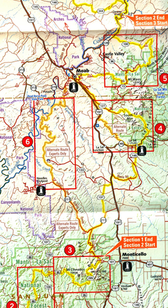
That’s where the Utah Backcountry Discovery Route (BDR) comes in. The folks at Butler Maps, along with the folks at Touratech and others, have been doing a series of these exercises, charting–and then riding to make sure it works–routes across entire states mostly off the pavement. For Utah that route runs north-south but with all the twists and turns to conform with topography it must be double the miles vs. as the crow flies.At the south end the route starts where US 163 comes into the state a little southwest of Mexican Hat. A bit north of Mexican Hat the route leaves the highway, heading up along something called Valley of the Gods Road. Now, that sounds promising.
The next prominent area I see on the map is a stretch through the Manti-La Sals. These are a cluster of mountains that I’ve looked at and admired for years. But I’ve never gotten into them. All the paved roads go around them.
This would be a good time to mention that this map more than others has warnings that you will want to pay attention to. In more than one place it says “Roads may be impassable when wet.” Boy, is that an understatement. I remember talking to Bill Eakins when they were developing this route and he told me of going out on a sidetrip at one point and getting caught in rain. While only a few miles from camp, it took hours to get back due to the mud that just cakes the tires.
We had a similar experience with cars quite a few years ago. We were headed to the north end of Canyonlands and drove all night to get there, reaching the road to Island in the Sky just before dawn. We drove in over from ground but as the sun came up it started to thaw. The mud got worse and worse till we finally decided we had better turn around. But by then, everything we had already been through had gotten much, much worse. We got out and pushed three cars for miles, taking most of the day, getting ourselves and the cars caked in red mud. Jerry told us years later that every time he washed that car for as long as he owned it there would always be red dirt on the driveway afterward.
The other warnings are where orange highlighted routes branch off from the normal yellow. These are marked, “Alternate Route, Experts Only.” Yeah, we’re separating the men from the boys here.
Further north, in the area west of Duchesne, the route runs up through the Wasatch Range, an area I’m familiar with. But you can bet you’ll be seeing parts of those mountains you’ll never see from the road. And they’re pretty beautiful from the road.
At the north end, the route comes out at Bear Lake, at Garden City. When you get here, even if you aren’t following the Utah BDR, you’ve got to stop and have a raspberry milkshake. It’s the specialty of the town. Good way to cap off your ride.
Biker Quote for Today
On a bike, no one ever asks, “Are we there yet?”

