Exploring Unpaved Colorado: Tarryall and the Hayman Fire
Monday, June 24th, 2013The whole point of getting a dual-sport bike was to explore parts of Colorado where the road is not paved. We did that this weekend.
The plan was to go down the road to Tarryall Reservoir and then loop back up to Bailey on a series of roads. We didn’t follow the agenda.
First off, we got off U.S. 285 about a mile and a half east of Jefferson, rather than at Jefferson as planned. That put us on Park County Road 56, Lost Park Road, rather than Park CR 77, which is Tarryall Road. That was fine because CR 56 was gravel whereas, as we learned, CR 77 has been paved all the way to Tarryall Reservoir. We ended going up through some beautiful country that we had never seen before, and that’s the whole point.
We met up with Tarryall Road a little north of the reservoir and cruised past and the pavement ended. But only for now. Turns out that the entire way from Jefferson down to Lake George, on U.S. 24 just west of Florrisant, is in the process of being paved. And what a nice route! Once they finish this will be a must-ride street bike route. It’s not very often that an entire new paved road becomes available. This will be a good one.
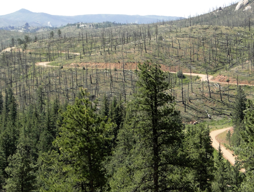
We didn’t go all the way to Lake George, however. I had been reading in Steve Farson’s terrific book, The Complete Guide to Motorcycling Colorado, about Matukat, a series of roads that runs from Bailey down past Wellington Lake and down through the heart of the area burned by the Hayman Fire a few years ago. This road meets up with Tarryall Road a few miles north of Lake George and we turned onto it, heading back north again.
As Steve describes it in the book, “From the roads you ride to the sights you see, this route delivers big time.”
Part of the route is wooded; much of it shows the charred landscape of the fire, although things are starting to green up again. It will be many years before the forest comes back the way it used to be but that provides an opportunity. We couldn’t help but think about how different the view is with so many of the trees gone. There were many places where we could see forever and the whole landscape was visible. If there had been tall trees lining the road we would have been happy to find the occasional unobstructed view so we could see the area around us. In fact, it makes me think about going back and shooting a bunch of photos from specific spots and then doing so again every 5 years for the next 30 years or so. And then what an interesting exhibition I could put on!
So we diverged from the agenda again along here. There are a number of intersecting roads and they’re not all well marked, so we missed our turn that would have taken us up by Wellington Lake and out at Bailey. Instead, we came out onto CO 126 down near Deckers and followed it up through Pine to catch U.S. 285 at Pine Junction.
Oh well, that just leaves us with a piece of road we still have to get to. Next time! And next time we’ll reverse course and head south from Bailey. And then probably find some different road going somewhere else. I mean, we’ve already seen Tarryall Road now. Although I will be back there on my Concours or my CB750 when that road is finished.
Recent from National Motorcycle Examiner
Going two-wheel on Ride to Work Day
Biker Quote for Today
One day, I will take it easy. Today won’t be that day.

