Archive for the ‘Colorado motorcycle rides’ Category

Black Forest Exploration

Monday, October 28th, 2013
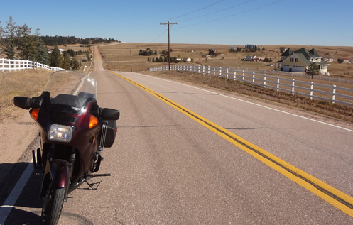
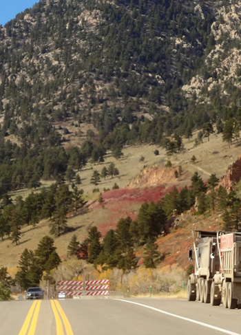
Pavement turns to gravel just down that hill

Looking back to where the pavement ends.

Sunday was such a gorgeous day I had to ride. The only question: where?

It was clear I wasn’t going to the mountains. Last week’s ride convinced me that I won’t be heading up in elevation till things warm up again next year. So I got to thinking about the Black Forest area, down toward Colorado Springs. I’ve never explored that area, and wasn’t even sure there were many paved roads down there, so it seemed like as good a time as any to find out.

Blasting down on I-25 I planned to get off at Monument but came upon an exit just north of there that I had never taken. This was exit 163, labeled County Line Road, Palmer Lake. Time to explore. I headed east. West would have taken me to Palmer Lake and I’ve been there plenty of times.

I couldn’t really tell but looking just now at Google Maps I see this entire area is heavily built up, with roads and homes covering the entire area. It’s hilly with a lot of woods. I just headed east and once I came over a ridge the trees ended and so did the development. It was mostly just grazing land from there until I hit CO 83, which comes up out of the Springs, through Franktown and Parker and back into Denver. At the highway I continued east because I could see a lot more hills and woods up ahead.

By the way, this road is also called the Palmer Divide Road, so it must be up pretty high, but on such a great fall day it was just as warm and nice as you could ask for.

I was only able to go a few more miles through the trees when I came over another ridge and not only did the trees peter out, so did the pavement. You can see that in the photo above, with the asphalt ending right where that road heads off to the right. This is exactly the sort of thing I bought the V-Strom for but I really wanted to ride the Concours this day so that meant turning around.

I guess I really need to plan things out more carefully. Last week I took the V-Strom on a ride that would have been better suited to the Connie. This time it was the reverse. I’ll figure it all out some day.

The other thing I keep telling myself I should do–but never remember when it matters–is to look at the map before I go out. I often come to a place where I think, “hey, that looks like an interesting road, I wonder where it goes,” but except when I’m in my most adventurous mode I am reluctant to find myself in a spot where I only hope there is a connecting road up ahead or else have to turn around. I wouldn’t have to follow a predesignated route, but it would be good to know that if I go this direction long enough I will come to some road that will get me out of here.

Anyway, I turned around and headed back to 83 and turned north and just cruised on home. Not as much of an exploration as I had hoped. But now at least I’ve looked at the map and I know I want to go back on the Suzuki and keep going on that road, off onto the gravel. You see, after a few turns you go north just a short distance and then the road runs along Kiowa Creek, up toward Elbert. That looks like a nice ride. I’m gonna go check it out.

Biker Quote for Today

Motorcycles are better than men/women because motorcycles don’t care if you are late.

Exit Tours M/C Does Off-Road Tours

Thursday, October 24th, 2013
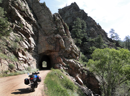
V-Strom On Phantom Canyon Road

Phantom Canyon Road appears to be one part of one of these tours.

This post has been updated as of January 2022.

There’s no way I can keep up with the magazines I subscribe to when I’m working a full-time job–which I am now–so I’m always way behind. I just read the May issue of American Motorcyclist and was very interested to find a cover piece about a tour outfit here in Colorado. Got to check these guys out.

It’s an operation named Exit Tours M/C and it took some reading and some looking at their website to figure out that–at least as far as I can tell–they are a nonprofit organization that puts on three or more rides a year. Not that they’re a bunch of do-gooders; my take is that folks from three motor sports dealerships in the Buena Vista area put this thing together to offer these rides and they presumably benefit by sales of gear and bikes. Nevertheless, as a nonprofit, their prices for their tours are pretty reasonable.

As a nonprofit, or club, annual membership is now $425. For this membership fee you get one club ride per year at no additional cost and then second and subsequent rides are $299. Also, family members can come on ride at the discounted price of $249.

Here’s what Mike Brown, the honcho of the group, had to say about the outfit:

Attempting to define our Niche.

  • Club Rides for Adventure, Dual Sport motorcycles and plated dirt bikes.
  • Club Rides in the Heart of the Rockies, Northern New Mexico, Central California and the Las Vegas Valley Loop.
  • Any competent motorcycle enthusiast can join the club without an invitation, and come enjoy the camaraderie of like-minded enthusiasts.
  • Our Club rides are for competent Riders. We do not offer training, classes or play games.
  • Exit Tours club rides start and stage on private property, and either loop back to the staging area or travel to an overnight destination with luggage portage. We portage your gear so you may ride unencumbered.
  • Most Club rides include camping and some meals.
  • Our club rides are not ‘guided’, we use Ride With GPS which is cell phone compatible and easy to use and understand.
  • Ride With GPS works without a cell signal.
  • Club membership includes Ride With Membership for said event(s).
  • You must have either a cell phone or GPS unit to navigate our routes. A mount and a way to charge said phone or unit.

Back to our Niche of riders:

  • Competent Riders who want to share the camaraderie of riding and camping, bonfires and bench racing.
  • But don’t know where to ride or how to tie trails together for a cohesive ride in outstanding, often remote locales.
  • Exit Tours sets up camping and meals, bonfires, supplies a T shirt and porta potties.
  • The Club supplies GPS tracks mapped by our local experts.
  • Multiple Loops for A&B riders and some C loops with GPS tracks of your choice for Dual Sport & ADV rides.
  • Trail rides and exclusive Adventure rides are generally one route, but we do not encourage riding in large groups.
  • We generally do not suggest riding in groups larger than 6 riders.
  • We do not cater to ADV riders who like to ride alone or carry all their camping gear.
  • Generally club ADV riders will transport their motorcycle in a truck to save their tires for the dirt.
  • We do not tailor our routes to smaller foo foo Dual sport motorcycles. Most Club Dual Sport Routes are challenging, with as little pavement as possible, and best ridden on Plated Dirt Bikes or 250 to 700cc Factory Dual Sport Models.
  • If you like challenging 2 track and singletrack you will love Exit Tours Dual Sport Routes.
  • The Adventure loops use more dirt roads and jeep trails, some paved passes and are Adventure bike friendly.
  • Club Trail rides are just that. Trailrides with as little pavement as possible. Using pavement only to access amenities and lodging or camping locales.
  • On all our rides we encourage the use of the Buddy System. Team up with others who have mutual talent and desires for the ride. How often to stop to rest, take photos…
  • Buddies wait at intersections until the next rider acknowledges they are coming the correct direction, and if buddies get lost or don’t show up, go back to the last place they saw each other.
  • With the multiple loops on offer, generally Exit Tours Club Rides do not have sweep riders.

So this is just an FYI. If you or anyone you know is looking for this sort of thing, guess what, here it is. Maybe next year I’ll try to wangle a free trip in exchange for writing about it. You’ll see it here if I do.

Biker Quote for Today

Serious. Just like that scene from the matrix, except the chick was me and the ducati was a klr. — DirtyDog

Not a Day for a Mountain Ride

Monday, October 21st, 2013

OK, I admit it, I am just as curious as anyone else to see an area I’m familiar with after disaster has struck it. I had been thinking for a while that I’d like to see the aftermath of flooding in Boulder Canyon, and that didn’t seem like an unreasonable thing to do considering that they got the canyon completely open again pretty quickly.

Coal Creek Canyon Roadblock

Who knew Coal Creek Canyon was not open? Not me.

It was Saturday and I got on the V-Strom to go have a look. It was a gorgeous day, warm and sunny, and I figured I wouldn’t need the electric vest. I don’t yet have a hook-up for the vest on the V-Strom, so if I wanted to use the vest I would have needed to have taken a different bike. I wanted to ride the V-Strom.

Blasting out 285 it started getting chilly with the high-speed breeze but I knew I was only going to be going fast for a short while. It also started getting quite windy. I turned north on C-470 and cruised up through Golden and onto Rocky Flats on CO 93. I had decided I would run up Coal Creek Canyon and catch the Peak-to-Peak to Nederland and then come down Boulder Canyon to Boulder. Didn’t happen.

As I turned off 93 at the road to Coal Creek Canyon there was a sign flashing that said “Highway 72 closed to Blue Mountain.” Say what? Where the heck is Blue Mountain? Is that a mountain, a town, a road, . . . ? So I decided to ignore the sign.

There was obviously something going on because all along the road there was a pipeline that had been laid aboveground–presumably temporary–carrying who knows what into the canyon. And there were trucks. And then there was that roadblock in the photo above. Figuring on pleading that I had no idea where the road was blocked to because I don’t know where Blue Mountain is, I went past the roadblock.

Not far beyond, however, there was another roadblock, this one manned by a state trooper. No skipping past this one. The guy I spoke to said Coal Creek got a lot worse flood damage than Boulder Canyon or several others. Really? I told him honestly that I had had no idea that was the case. And I said I guessed I’d take a different route.

So back to 93 and on up to Boulder I went. From there I headed up Boulder Canyon, figuring to just run up to Nederland and then back down. It was right near the mouth of the canyon that I saw some evident flood damage and repair. At about five bends the water wanted to go straight and when the bank interfered it ate away the bank. And the road. But fill had been brought in, the banks restored, new pavement laid, and a temporary guard rail set up. In truth, it was not all that bad and not all that big a deal.

I thought surely there must be worse upstream, but as I continued up the canyon I came upon a bunch of small houses and buildings right next to the water that appeared completely undamaged. How could that be? I would have thought they would have been swept away if there was serious flooding. Best I can tell, the creek was raging but the banks were enough to contain it for the most part. And it must have only gotten concentrated down near the mouth of the canyon, maybe from adjoining canyons adding their flow to the total. In other words, nothing at all like what happened in the Big Thompson.

By now the sun had gone into heavy clouds, the wind was whistling down the canyon, and the temperature was dropping as I climbed. I was wishing I had my electric vest and thinking maybe I wouldn’t go all the way to Nederland. Then traffic came to a complete stop. We all sat there for quite a while as probably 200 vehicles came by the other direction. Obviously there was something big up ahead that forced everyone to take turns using a single lane. That must be what I want to see, I thought.

Eventually we started moving and less than a mile further on we came to the delay: a traffic accident that was in the final stages of getting cleaned up. Wonderful. And now I had to keep going and oh me, what a long line of traffic was backed up heading down the canyon. When I finally reached a place where I could turn around and get into the line I was a long way past the accident site. And we didn’t move for 10 minutes or more. Maybe 15. You better believe I wished while sitting there that I had my electric vest.

Finally we started to move, went past the accident site where things were completely cleaned up, and crept en masse back down to Boulder. And then I headed home. Back in Boulder the sun was shining and the temperature was a lot higher than up in the canyon. I guess this was not a day to plan a ride in the hills.

Biker Quote for Today

You know you’re becoming addicted to riding when you make your passengers sit behind you in the rear seat instead of beside you.

Checking for Color in the High Country

Monday, October 7th, 2013
CB750 on Squaw Pass

I took the Honda up on Squaw Pass on Sunday. What a great day to ride!

All right, we had some snow, a hard frost, and now the weather has warmed back up. This is Indian summer, and yesterday (Sunday) was an absolutely perfect day for a ride in the hills. I figured I’d ride the Honda, partly because it gets the least use of my three bikes but also because those tires are getting old and ought to be replaced. Let’s wear them out!

I headed out to Morrison, where the bikes were thick as flies on something rotten, and cruised on up Bear Creek Road to Evergreen. Evergreen was the same as Morrison, bikes everywhere you looked. I wasn’t the only one who concluded it was a perfect day to ride. A time and temperature clock in Evergreen read 61 degrees and you couldn’t have asked for a nicer day.

I turned north on Evergreen Parkway to the left turn onto Squaw Pass Road. I was wanting to either find some fall color or see how far away we were from having the aspen leaves turn golden. I had seen a little color coming up the canyon but it seemed I needed to go higher. But the higher I went all I saw was aspen tress with their leaves already gone or else just brown. I’ve heard that moisture can affect the change of color so maybe we’re just not going to get a gorgeous fall this year.

Cruising up Squaw Pass Road I still didn’t see much color, but I did see some major work on the road. A lengthy stretch was brand new asphalt, so new it isn’t even striped yet. I had one particular spot in mind where I wanted to stop and shoot a picture but when I got there they were working on the road, despite it being Sunday. In fact, they were laying asphalt at the exact spot I planned to stop at the moment I got there so I kept going and got the shot above a little further down the road.

I didn’t go all the way over and down to Idaho Springs because I didn’t want to get stuck in the Sunday afternoon mess on I-70 coming back to town. Instead, I went on a ways and then turned back. That way I saw the road in both directions and can give you this report in case you’re up there soon.

The road work starts once you enter Clear Creek County. The road surface is smooth and perfect, unstriped as I said, but also with no shoulder in place yet. What that means is that if you wanted to pull off you’d be looking at a sheer drop-off from the asphalt of four to six inches. Not too many people are going to want to try that.

Going west, which puts you in the north lane, the lane is clear and perfect. Heading back east however, in the south lane, there is still some snow and ice on the road. Off the road, in the shadows, there was a good bit of snow. While the road has been cleared, there were just a few small patches where not all the snow was cleared off the pavement. Plus, there are some spots where melting snow flows onto the pavement and then freezes. When I came over around 2 p.m. this was mostly melted and the road was just wet, but earlier or later in the day it could be a different story. And there was still some ice in a couple spots even at that time.

I’m presuming this is indicative of other roads in the high country at this point. If this government shutdown continues and I continue to not be working I plan to check out a few more in the next few days. Hey, it’s a great opportunity to ride and it gives me something to write about here. I will make the point, by the way, that while Congress is planning to pay federal workers for their time off from work, I am not a federal employee, I’m a contractor. For me it’s unpaid time off. But I still get to go out and ride during this perfect weather.

Recent from National Motorcycle Examiner
AIMExpo will debut in Orlando Oct. 16-20

Biker Quote for Today

Two roads diverged in a wood, and / I took the one less traveled by, and / now where the hell am I?

No Riding in the Big Thompson Canyon Any Time Soon

Thursday, September 19th, 2013

If you live in Colorado this is not news, but if you live elsewhere and have plans to come ride in Colorado it’s important news. No one is going to be doing much riding in the Big Thompson Canyon any time soon.

Big Thompson Canyon

An elevated portion of the road down the Big Thompson Canyon before the recent flooding.

Probably everyone across the country knows we’ve have major flooding here in Colorado recently but what has happened in the Big Thompson may have escaped your attention. I knew it got hit pretty hard but it wasn’t until I watched this TV news video that I realized just how bad it was.

Let’s get some history. Back in 1976 there was a huge flood in the Big Thompson that killed more than 150 people. When they rebuilt the highway they built it to prevent that sort of devastation again. Or so they thought.

In places in the narrow parts of the canyon where the road used to run right alongside the river, the new construction raised the roadway 20 feet or more above the previous level. Watching that video you can see that a large part of that raised construction got washed away. It’s an aerial view so it’s hard to see for sure, but the walls of the elevated portion seem to have come through reasonably well. Nevertheless, the decking, i.e., the road surface, is totally washed away in some places and substantially missing in others. Not quite sure how that happened but it did. So much for the best laid plans of highway engineers.

So of course you have to wonder what they’ll do this time to rebuild the road and make it last. The one thing you don’t have to wonder about at all is whether there will be any riding in that canyon in the next six months or more. If they just put things back the way they were it would probably take that long. If they try something new it will first take time to come up with ideas and develop those ideas and then put them into place.

The Big Thompson is a beautiful canyon and it’s a great place to ride. Just don’t plan on doing that till next year some time.

Biker Quote for Today

Half the adventure is trying to figure out when and where to stop for a photo.

Two Motorcycle Events You May Want to Attend

Monday, September 16th, 2013
Civilian Top Gun competition

The Civilian Top Gun competition a couple years ago.

There are a couple things coming up very soon that I want to direct your attention to.

First is the 5th annual Civilian Top Gun Rider Competition. The non-civilian Top Gun competition is for motorcycle cops. That’s an annual exhibition that is really good, with those guys putting their big cruiser bikes through tight turns that most people can’t even do on a small bike.

So this other event is for the rest of us, but don’t think for a minute that that means the riding you’ll see is second-rate. You don’t have to be a cop to know how to ride really, really well.

This thing will be taking place this coming weekend, Sept. 20-21, at Fay Myers Motorcycle World, 9700 E. Arapahoe. And it’s free–no admission charge. Apparently it will be going on both days so cruise on down, and prepare to feel like you really aren’t that good a rider after all, no matter what your ego would like you to believe.

The other event is a week later, Saturday, Sept. 28. This is the Small Bike Ride.

Todd Wallis is the organizer of this event, which is in its fourth year. Todd is a guy who likes to restore old bikes, and he particularly likes the smaller ones. So he put together this event–it’s just a ride; go have fun–for old bikes with engines 250cc or smaller. Or, if you ride a pre-WWII bike of any size you’re welcome, too.

Riders will be starting out from a spot in Deer Creek Canyon, 9880 West Deer Creek Canyon Road, to be exact. The ride starts at 9 a.m. and will be cruising–rather slowly–through the hills, for about 100 miles.

So go have fun.

Recent from National Motorcycle Examiner
Only a biker knows . . .: Motorcycle wit and wisdom, #28

Biker Quote for Today

Think of your thumper as a big pump, happily sucking and blowing down the road.