Archive for the ‘Suggested Rides’ Category

17 Passes in 32 Hours

Monday, July 13th, 2009

Steve Smith had asked my assistance in planning his Colorado ride and he sent me this follow-up now that he’s back home. He rode some passes I’ve never been on. Makes it especially interesting. Here’s Steve’s report.

***************************************************

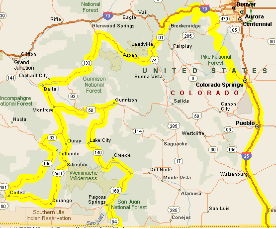
My trip started in the western North Carolina mountains on Friday, July 3. My dog and I made Oklahoma City that night thru some nice hot weather. Saturday, the 4th, we kept on to New Mexico and up thru Taos to Antonito, Colorado area. I was not sure just exactly where some of the campgrounds were located on your website, so I took the safe route and checked AAA where I found the camp ground at Mogote. The people were nice and had a free cook out that evening. The facilities were nice with a shower and nice shaded camping area for $18.
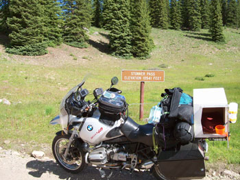
sport bikes
  Stunner Pass

The next morning I rode past the camp grounds that you mentioned and they looked very nice. My goal was to ride to the pass and find a sign and get a picture, so my first pass that morning was La Manga. It was a nice ride over to Cumbres for my second pass in just 30 minutes or so. I retraced my tracks back across La Manga to the forest road 250 and up to Stunner Pass. This road was very navigable but not recommended for a shiny Harley or Goldwing, due to the rocks and potholes. I was riding a loaded 1150 GS and it was slow going in a few places. As with all the roads in Colorado, they are all very scenic with great vistas. I kept going north up to the highway and made a left turn to Wolf Creek Pass for my 4th pass that day.

The next two passes were easy to achieve on a great road up thru Creede and on to Spring Creek Pass and then Slumgullion Pass for the 5th and 6th passes. Just past Slumgullion towards Lake City I made a right turn towards Los Pinos Pass. This road was even rougher than the road to Stunner but still was very scenic. At this pass the sign had disappeared so I have no picture of that one.

Once thru the pass it was about 29 miles out to Hwy 114 and to North Pass for my 8th pass. A u-turn took me back to Gunnison where I went up thru Crested Butte and on towards Kebler Pass. Before I got to that one there was a road off to the left to Ohio Pass. I found no sign but a nice rocky, pot-holed road for a couple of miles. Kebler was my 10th pass that day and the road on out to Paonia was a very nice gravel road. The aspen surrounding the Lupines and was a sight to behold. That evening I camped at the Redstone campground for $32. Yes I went over McClure Pass but since it was under 10,000 ft, I didn’t count it for that day.

By the end of the day I had ridden over 10 passes above 10,000 feet and was done with the pass counting in 10 hours.
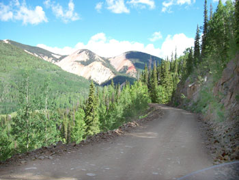
sport bikes
  Los Pinos Road

The next morning, I left Redstone and ventured up thru the slow traffic at Aspen to Independence Pass. Wow, the views were great. My next pass was Tennessee Pass north of Leadville. I retraced my track back to Leadville for lunch and then up to Fremont Pass. I continued north to I-70 over Vail Pass and then on to Shrine Pass, just a short 3 miles from the rest area on a good hard packed road that any bike could handle.

Next in my sights was Loveland Pass and then to Guanella Pass south of Georgetown, but the road was closed for construction so I went to Berthoud Pass instead. That was my last pass, as I told my sister I would be at her house north of Woodland Park at 4 PM. The road down thru Deckers was very nice and I was able to beat or avoid some rain and hail.

My total account was 17 passes over 10,000 ft. I started around 8 AM on July 5th and was drinking a cool one by 4 PM the next afternoon or 32 hours total. In hindsight I could have done more if I wasn’t so packed down and left my dog at home, but we had an excellent ride thru some very beautiful country.

I would not recommend Stunner and Los Pinos Passes for an inexperienced rider. That may be done better in a car or truck. On the other hand, any bike could make it, but it may be missing some parts that get rattled off during the ride.

***************************************************

OK, so thank you Steve for that ride description. Now I’m going to have to find out where Stunner and Los Pinos Passes are.

Recent from the National Motorcycle Examiner
Could there be an Eco Mobile in your future?

Biker Quote for Today

If it can’t do some dirt, why bother?

Texas Rides The Rockies

Monday, June 29th, 2009

Texas rides the Rockies map

I’m frequently asked to help people plan their routes when they’re coming to Colorado to ride, and I’m always happy to oblige.

Last year I posted a series I called “New Zealand Rides The Rockies” where I laid out the day by day rides of a group on New Zealanders planning to come here this year. Unfortunately, the world economic meltdown derailed their plans, at least for now.

However, if you don’t have to fly halfway around the world and you don’t have to rent motorcycles, coming to Colorado to ride is actually one of the less expensive vacations you can take. I can confirm that a good number of people are doing just that.

Among them are Ray and some of his friends from Texas, who are cruising around Colorado right this moment, presuming they didn’t have any last minute glitches. I’m not going to lay this out in the detail I did for the Kiwis but I figured you might have some interest in their plans.

Days One and Two

Ray and friends are coming from the Dallas-Ft. Worth area (I believe) and were riding to Las Vegas, NM, the first night. From there, on Day Two, they were planning to head north to Taos and on up to where they would reach U.S. 160 at Fort Garland. They planned on taking U.S. 160 west to South Fork, then CO 149 over Slumgullion Pass to Lake City, and then the gravel roads over to just south of Ouray. Ridgway was their destination for the night.

These plans were revised considerably when I pointed out to Ray that it would be a much nicer ride to take U.S. 64 west from just north of Taos, via Chama, and then U.S. 84 up to Pagosa Springs. From Pagosa, a run over Wolf Creek Pass would put them at South Fork. I also mentioned that they must be riding dual sport bikes if they were planning on taking that road west out of Lake City.

Apparently they aren’t, so that road was nixed. Instead, they adopted my suggestion of the Chama route and then just continued on through Lake City to Gunnison for the night.

Day Three

Day Three was to be a fairly easy one after a long Day Two. Heading west out of Gunnison they planned to stop at Black Canyon of the Gunnison National Park and ride the South Rim Drive and the East Portal Road. Then they would make the easy cruise to Ouray and make that their headquarters for two nights.

Day Four

Day Four is planned as a circle route through Ridgway, Placerville, Telluride, Cortez, Durango, Silverton, and back to Ouray. This will take them over Lizard Head Pass and Red Mountain Pass. Red Mountain Pass, of course, is one of the best in the state.

Day Five

On Day Five, Ray and friends are heading north through Montrose and Delta and will then head northeast on CO 92 to Hotchkiss and up and over McClure Pass on CO 133. At Carbondale they will turn southeast on CO 82 through Aspen and over Independence Pass, another of Colorado’s very best.

A run through Leadville and then down Fremont Pass to Copper Mountain will put them at I-70, where they will head east to Silverthorne. They’ll take U.S. 6 up over Loveland Pass and end up for the night in Idaho Springs.

Day Six

From Idaho Springs our travelers will head south on CO 103 up Squaw Pass with a sidetrip to the top of Mount Evans. From the Bergen Park area they’ll head south to Evergreen and on to Conifer where they’ll pick up U.S. 285 for just a short jaunt. At Pine Junction they’ll head south on CO 126 through Deckers and on to Woodland Park and Colorado Springs.

Days Seven and Eight

In the morning of Day Seven, Ray and the rest will make a run up to the top of Pikes Peak, then head back down and blast homeward as far as Amarillo. Day Eight will see them home again in the Dallas area.

Recent from National Motorcycle Examiner
10th Annual V2V: Victory riders ride Victory Highway

Biker Quote for Today

Fun is not a straight line.

New Motorcycle Examiner Takes on Colorado

Thursday, June 25th, 2009

Dom Chang, also known as Redleg, is off and running hard as the newest motorcycle Examiner in Colorado. Some of you may already know Dom/Redleg as the blogger of Redleg’s Rides, which is where I met him.

Colorado Motorcycle Travel ExaminerAs you may know, for one year I was the Denver Motorcycle Examiner, and have now become Examiner.com‘s National Motorcycle Examiner. That created a vacancy at the local level so I contacted Dom to ask if he would be interested in the spot. “Heck yes I would,” was his reply.

The folks at Examiner have their own approach to these things, however, which are not always clear to me, so Dom actually ended up as the Colorado Motorcycle Travel Examiner.

Whatever. Doesn’t matter to me, and I presume it doesn’t matter to Dom. The point is, he’s burst out of the starting gate like a rocket and is putting up a lot of great information about places to ride in Colorado. And Dom is no weekend biker; he rides all the time. Here’s his Examiner bio:

A late blooming motorcycle rider, Dom explores motorcycle-accessible Colorado year round. Averaging 20 thousand plus miles a year on his beemers, he’s a ride-reporting, farkle reviewing, basic motorcycle servicing, solo touring rider and blogger.

He also had this to say in his first Examiner post:

I’ve been motorcycling since the Spring of 2006 and have accumulated over 50,000 motorcycling miles since then. I commute to work on my motorcycles unless there’s ice or snow on the road. I’ve traveled the length and breath of Colorado in search of motorcycling destinations and byways, this information and experience I hope to relate to you in future articles.

Did I mention that Dom is a terrific photographer? Dom shoots pictures wherever he goes and frequently stitches multiple images together to give you great panoramic views. Unfortunately, Examiner does not accommodate his photography the way his blog does, but when he presents one of these panoramas on Examiner he links to the shot on his blog so you can really appreciate it.

So check him out. Blog and/or Examiner, Dom’s sites are good adds to your Favorites list.

Recent from the National Motorcycle Examiner
One more sweet motorcycle road in southern Utah

Biker Quote for Today

Ride, Eat, Sleep, Repeat, Repeat, Repeat………..

Some Great Motorcycle Roads in Southwestern Utah

Monday, June 8th, 2009

When we get out of Colorado, one of our favorite places to ride is Utah. Judy and I spent the last week in southwestern Utah, and although we were there in the car, not on the bike, I spent a good bit of time while we were there scoping the place out for next year’s OFMC ride. Here’s a quick recap of what I’ll be pitching to the guys to convince them this is the trip we want to make. And here’s a map showing the roads we took. Unfortunately, the mapping software doesn’t show the actual roads in some instances due to the degree of zoom, but I’ll try to be sufficiently specific.

map of southwestern Utah
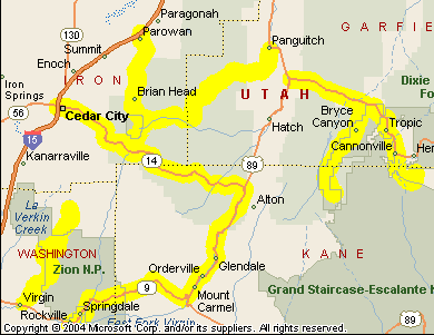
First off, we blasted out on the interstate to the ski area of Brian Head. This was about 650 miles, which is one of the reasons we didn’t go on the bike. We are definitely not iron butt candidates. We got off I-15 at Parowan and took Utah 148 to Brian Head. It was a nice ride up a canyon, and steep. Up at the town they have a sign telling folks heading down that it’s a 13% grade for the next 10 miles. Of course that spells fun on a motorcycle.

Utah 148 runs on south from Brian Head through Cedar Breaks National Monument. We had never been there before and it was gorgeous. High cliffs looking down on sculpted red canyons. Numerous scenic overlooks. Very nice. Highway 148 connects a little south of Cedar Breaks with Utah 14. We took it first to the west, to Cedar City. More gorgeous canyons and incredible panoramic views. Highly recommended.

On our second full day we again headed south on Utah 148 but quickly turned off heading east on Utah 143. This goes to the very nice small town of Panguitch, and from there we turned south on U.S. 89 just a few miles to Utah 12. This road very quickly comes into Red Canyon and it’s a stunning sight. It portends what you’re going to see further up the road in Bryce Canyon, Red Canyon is fabulous in its own right.

Another 10 miles or so down the road you do run into the road that goes south into Bryce Canyon. This is Utah 63. You have to pay to get into the park, $12 per person for motorcycles, but it’s worth it. Take the road all the way to the end, at Rainbow Point, and then stop at the turnouts and scenic viewpoints on your way back up. They’re all on your right that way, and that’s a lot easier than constantly turning across traffic.

After Bryce we continued on Utah 12 down to Cannonville, where we turned off on Cottonwood Road and headed down to Kodachrome Basin State Park. This is nowhere near as spectacular as Bryce Canyon but it’s a nice side trip if you have the time. The road is paved all the way in.

We rested our tired feet for a day (we did a lot of hiking) and then headed out on a two-day tour of Zion National Park. Back down Utah 148 to Utah 14 to Cedar City, and then south on I-15, until we came to the turn-off for Zion National Park-Kolob Canyons. This is just a short jump off the interstate, about five miles to the end, and you get a spectacular view of a different part of the park than most people see. I never knew it was here. Admission is the same as at Bryce.

Then back on the interstate, down to Utah 17, to La Verkin, where we got on Utah 9. Arriving at Virgin, there was no sign for Zion but Judy had done her research and knew that if we turned off on Kolob Road it would take us up into the park. This was absolutely the highlight of our trip. This road is sensational! It’s a gorgeous ride and the views are the best you’re going to see in this park. And almost no one knows it exists. Well, now you do, so don’t miss out on it if you’re down this way. It’s incredible.

Back on Utah 9, we came to the south entrance to Zion and this is touristville. Springdale has turned into a little Aspen since the last time I was there and you can no longer drive up Zion Canyon, except during the off season. They run frequent shuttle buses and that’s the only way to go. I was not thrilled with the idea at first but when I saw how much nicer it was than the incredible congestion I remember I decided it was OK. But really, I could just about skip this part of the park. It’s nice and all, but I’ve been there a number of times and it doesn’t thrill me any more.

Heading on out of that part of the park you then climb a terrific series of switch-backs and then cross through a long tunnel with numerous windows, opening in the rock walls, until you get outside of the canyon. There is a parking lot right at the east end of the tunnel and a trail that leads back over the hump to give you an incredible view of where you just came from. I strongly recommend this hike. It’s not far and it’s well worth it.

On out of the park on Utah 9 and then north on U.S. 89, until we reached Utah 14 at its east end, and then back to Utah 148 and home to Brian Head. Very scenic the entire way. We loved it. We’ll be back. And I’m hoping the OFMC will be heading that way next year. I do have an ace in the hole with the guys: Mesquite, NV, is just down the road from here about 45 miles and they love to gamble. Utah here we come.

Recent from the National Motorcycle Examiner
ABATE sponsors racer in outreach to sportbikers

Biker Quote for Today

Sometimes you end up going down the wrong road. That’s an adventure.

Independence Pass, Mount Evans Now Open; Loveland Pass Closed

Thursday, May 21st, 2009

Independence Pass
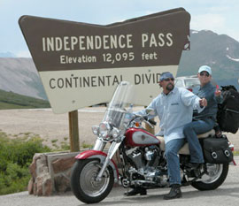
Note to the world: Colorado is open for the season.

That’s right, with today’s opening of Independence Pass and CO 5 to the top of Mount Evans opening tomorrow, all the seasonal roads are open. Even Trail Ridge Road is open, although the Colorado Department of Transportation (CDOT) reports that it is icy in spots.

One note of interest, however, is that US 6 over Loveland Pass is closed at this time. This is not a seasonal road, but CDOT says it is “closed for emergency road repair until further notice.” Apparently they just closed it yesterday. That’s a good thing for me to know because I was planning to head up over that pass in just a couple days.

Here’s a bit more info from CDOT:

U.S. 6 over Loveland Pass is closed due to a culvert failure, about 1 ½ miles east of the summit. Excess water has washed out the bottom of the culvert. Safety considerations will not allow the road to be open to traffic due to a loss of roadway support over the culvert. All traffic will be detoured though the Eisenhower Tunnel on Interstate 70. Loveland Pass will remain closed until further notice. The Colorado Department of Transportation will send out more information when it becomes available.

Recent from Denver Motorcycle Examiner
Run For The Wall nearing its destination

Biker Quote for Today

If you don’t make it the first time, back up and try again, only faster!!

Recommended Colorado Bases for Day Rides

Monday, April 13th, 2009

Red Mountain PassIf you’re planning to ride Colorado and want a base of operations from which to take day rides, where should you stay? This is a question I received twice recently so it occurred to me that I ought to post my answer here. In this case, I’ll be responding to this particular question.

We will be trailering our bikes to Colorado from Florida and plan to ride from August 1st through August 8th. We’ve been out west to ride in other states and usually stay in two separate locations. This allows us to ride a different route each day and really see the area. What would you recommend as the two best areas to stay in while doing day rides?

This was my reply.

I would suggest these two spots as your home bases: Ouray and Breckenridge. Here’s my thinking.

Ouray, first of all, is gorgeous. Of all the cool places in Colorado, Ouray stands out. If you end up not staying there you must at least go there. Of course, Ouray is at the northern end of one of the best roads in Colorado, Red Mountain Pass. (By the way, this photo is of Red Mountain Pass approaching Ouray, although it’s not usually so crowded. This traffic resulted from a construction blockage.)

That also positions you to take the loop and do Lizard Head Pass and go to Durango and Mesa Verde. You can also go north to Montrose and then visit the Black Canyon of the Gunnison and take the Unaweep Canyon road.

And there’s a lot more in the area. You could spend your entire vacation there.

Breckenridge gives you access to a whole other part of the state. Go south over Hoosier Pass into South Park and take any of several roads that converge there. Or, go north of I-70 and loop up through Steamboat Springs over Rabbit Ears Pass or go east over Trail Ridge Road.

Also from Breckenridge you’re very close to Loveland Pass and Mount Evans.

En route from one base to another you might want to make a point to go via some route that takes you over Independence Pass. This is another of the very best.

So there are some ideas to consider. If you have questions I’m happy to address them to the best of my ability. Truth is, though, you really can’t go wrong riding the Colorado mountains, wherever you go.

Biker Quote for Today

Don’t ride so late into the night that you sleep through the sunrise.