Archive for the ‘Routes to Add to Website’ Category

Cottonwood Pass and Taylor Canyon Now Up On Website

Friday, February 19th, 2010

Eight months ago I went up Taylor Canyon and over Cottonwood Pass shooting pictures and gathering information to put these places up on the Passes and Canyons, Motorcycle Touring in Colorado website. Taylor Canyon is a beautiful canyon, with lots of good motorcycle-accessible camping spots. Cottonwood Pass is only paved on the east side but the gravel road is passable on the west. Both deserved to be on the site.

I’ve been busy. But I finally got it done. Here are some photos from these places.

Taylor Canyon

Cottonwood Pass

The top of Cottonwood Pass

Biker Quote for Today

To me, the best kind of trips are the ones you planned on the way, allowed yourself to change, and maybe didn’t end up where you expected.

Douglas Pass Deserves to Be on the Website

Monday, September 7th, 2009

Douglas Pass, in Colorado

And here I thought I had all the good passes in the Colorado included on this Passes and Canyons website. Wrong. I just did Douglas Pass last week and it’s going to need to be added.

Update: I did, at long last, add this pass to the website. It only took about 13 months to make the time. Here’s the link: Douglas Pass

Douglas Pass mapIt’s not that I didn’t know this pass existed, because my buddy John rides that route periodically when the OFMC comes home through Dinosaur. John lives in Montrose so he splits off from the group in Dinosaur and heads down CO 139 home. He has told me there is a pass there but he never really impressed on me that this is a really nice pass.

So anyway, I was headed for the Salt Lake City area last week to cover the Bonneville Vintage GP and Concours and, although it was out of my way, I decided to check out this road. Yeah, I’m a little overdue. This was worth the extra miles. And I got photos and other information so I’ll be adding Douglas Pass to the website as soon as I can make the time.

One other note: I was also looking at Baxter Pass as a possible route but fortunately I had the chance to ask someone at a Colorado visitor center about it and we looked on the web. Baxter Pass runs sort of parallel to Douglas Pass, a little to the west, from Mack up to Vernal, UT, but it is a really bad road that even jeeps have trouble on. Just so you’ll know.

Update 9-24-12: I just got this note from Doug Bulkeley, saying “Just a note to tell you that Sept. 21, 2012, I came over Baxter Pass with a 34′ rv 5th trailer pulled by a 2012 Chevy 2500HD 4X4. Damn GPS said that was the quickest way. 5 hours later I disagree. I wouldn’t mind doing it again with an ATV and a camera. The only good thing was that it was dry. I may be working near Ridgway next summer. Oh, and by the way, I’m 70 years old.”

Recent from National Motorcycle Examiner
Beauty and history at vintage motorcycle Concours d’Elegance

Biker Quote for Today

I come from the era when you ride for an hour, and then you wrench for three hours, so the idea that you have a machine where you just ride, well, it’s not an alien concept, but I just feel I’m missing part of it.–Jay Leno

Taylor Canyon and Cottonwood Pass Are Keepers

Monday, July 27th, 2009

After cruising Kebler Pass last weekend we went on up Taylor Canyon and over Cottonwood Pass. This was another of those Colorado roads that I haven’t been on because it wasn’t paved and I wasn’t sure how good it would be on a motorcycle. I had been hearing that it was decent gravel, however, and needed to check it out.

sport bikes
  Cottonwood Pass looking west

Well here’s the verdict. It is not as good a gravel road as Kebler Pass. It is passable, however. I know this for a fact because there were Harleys and all sorts of bikes doing the ride. (Update: Cottonwood Pass was paved all the way some while later. It is now a great road on any bike.)

I knew that Cottonwood Pass was paved on the eastern side, from Buena Vista, and I have been up there on my bike previously. What I didn’t know was that on the western side, coming east out of Almont, you pass through Taylor Canyon, which is absolutely gorgeous, and the road is paved all the way to Taylor Reservoir. It’s only about 12 miles then from the reservoir to the top of Cottonwood Pass.

Considering all that, I would definitely add this road to my list of good rides in Colorado. Personally, I would prefer going east to west so all of the gravel would be downhill. I just feel more comfortable on a street bike going downhill on rough gravel. And some of it is rough, make no mistake. But if those Harleys can do it anyone can.

I’ll be adding Cottonwood Pass and Taylor Canyon to the website as soon as time permits. I have a lot of good photos but you’ll have to wait until I get the new page up to see the rest of them.

Biker Quote for Today

Destinations are merely excuses to ride.

I Finally Make it to Kebler Pass

Thursday, July 23rd, 2009

I have to admit I was feeling a bit peeved with myself with my failure to have ever made it to Kebler Pass, especially with all these out-of-state riders coming through and doing that route. That shortcoming got rectified this past weekend, and I have to say, it was long overdue.

Kebler Pass
  Kebler Pass is gorgeous

Kebler Pass is the extremely well-maintained, hard-packed gravel road that run from Crested Butte down to CO 133 over McClure Pass between Hotchkiss and Carbondale. This road may not be paved but even the biggest bagger can take this route with no problem whatsoever. That’s especially great because otherwise, when you go to Crested Butte, you have no choice but to go back the way you came in.

An additional benefit to doing Kebler Pass is that you can take a short side-trip and hit Ohio Pass as well. Just a short distance downhill from the sign marking the Kebler summit, Gunnison County Road 730 heads off southwest to Gunnison. Ohio Pass is just a short distance away and then it’s a rough road heading on down, good primarily for a dual-sport bike. Don’t take your Road King on this one. Extremely scenic, however.

So I want to thank Steve Smith, a rider from North Carolina who used this site to help plan his trip and then sent me his report. I didn’t even know where Ohio Pass was until he described his ride. And now I don’t feel so bad that he has been to Kebler Pass and I haven’t, because now I have.

Recent from National Motorcycle Examiner
Motorcycles 101: What to buy as a first bike

Biker Quote for Today

Enjoying life one ride at a time.

Update on Guanella Pass

Monday, August 25th, 2008

I wrote just three days ago about the conditions on Guanella Pass, so with that on my mind, when my wife wanted to head for the high country the next day I knew where I wanted to go.

The last time we were up there was two years ago, and what we saw then was what I described. Well, there is a lot that has changed in two years.

For one thing, the reconstruction work I mentioned has begun, and going up from the Georgetown side the road is horrible. Horrible! It’s one lane in several places, with traffic signals stopping you or letting you pass, but the road surface on most of it is so bad it’s amazing. I can hardly believe the county would let it get this bad, although I wonder if perhaps it is the heavy construction going on that has torn the road up like this. If that’s the case then of course they won’t want to repair the road surface until the heavy work is done. The project won’t be completed for another couple years.

After awhile you get past the mess and then the road is pretty good the rest of the way up. It’s mostly paved, although still rough, and just as you near the top it turns to gravel. It’s definitely passable. We couldn’t really tell what the condition was two years ago because it was all covered with snow at that time.

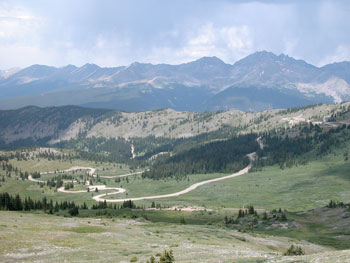
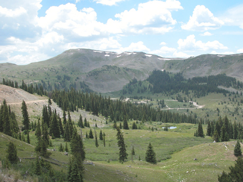
And it is beautiful up on top! It was beautiful last time, too, but it was an all-covered-with-snow beauty. I had forgotten just how spectacular it is when the snow is gone.

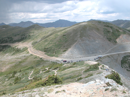
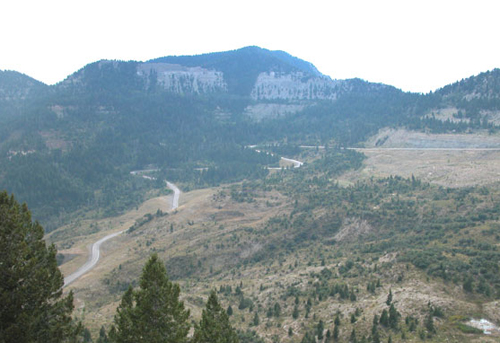
Heading on down the other side it continues as gravel and gets to be a lot of washboard. Then abruptly, about a mile from the top, you hit nice new asphalt. We guessed that this was where we hit the county line. If you look at the picture I included in the last post and you see the poor surface, that’s all been redone. The new asphalt continues for several miles and then you get back to the older surface and intermittent gravel. It’s all very passable, although if it has rained you will face mud.

So bottom line on all this, I still wouldn’t take a Gold Wing on this road but anyone who doesn’t mind doing some dirt would find this a really nice ride. You’ll need to go slow on the part where the surface is so bad but you definitely can do it. Just try not to get caught in a thundershower.

Consequently, I will be adding this road to the Dirt Roads and Side Trips page of the website.

Biker Quote for Today

Patience is the ability to keep your motor idling.
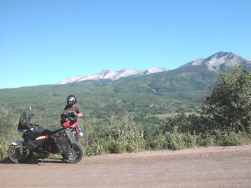
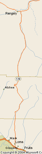
OFMC Route Was Big Boon for Passes and Canyons Site

Wednesday, July 23rd, 2008

Man, have I got a lot of work ahead of me. If you have gone through the Passes and Canyons, Motorcycle Touring in Colorado website thoroughly you know that even three years in it is still weak in information on some roads. The simple fact is that although I’ve been all over this state numerous times, there were some places I had not been back to since I started the website. Therefore, although I could show a map and talk a little about the route, I did not have the photos and other information I routinely collect and post.

Well, that’s about to change. The OFMC trip last week could not have been better tailored to meet my needs if I had planned the route myself with that in mind–which I did not do. I had made a list some time ago of 27 places I needed to get to. On this trip I hit 15 of those spots. It’s going to take time to work through it all but in the next few weeks you can expect to see improvements on a lot of pages, including:

And more. Here’s a map showing our route. What a great ride we had.

OFMC 2008 route

Biker Quote for Today

The ride IS the destination.