The Fall Color/Cemetery Dual-Sport Tour
Thursday, September 29th, 2011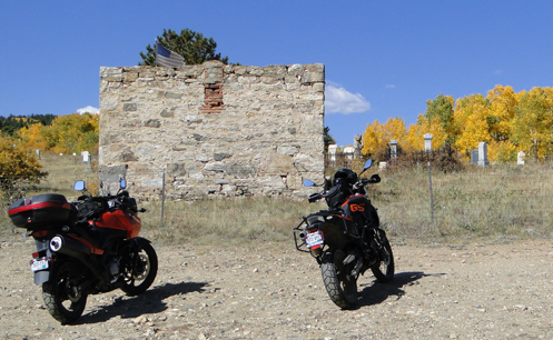
Had a terrific time with Ron Coleman of Western Dual Sport Motorcycle Adventures today dual-sport riding in the hills west of Boulder and around Central City. He was on one of his V-Stroms and I was on his F800GS. Oh, and I dumped the thing twice. Details in due time.
Ron dubbed this the Fall Color/Cemetery Tour for very literal reasons. The aspen are at their peak of color about now and here’s an interesting thing you may not know: cruising around in the hills above Central City there are numerous old cemeteries, with gravestones dating back to the mid-1800s. They’re actually very picturesque, with some very ornate markers.
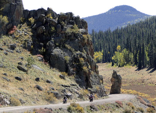
We headed out of Boulder going up Boulder Canyon but then turned off onto Magnolia Drive. This road climbs very steeply with numerous switchbacks that must have a road pitch of at least 15 percent. It was nice to be on a bike that was light and had great low-end torque. Up over a crest and the mountains to the west came into sight and the pavement ended. We wound our way along and then reached the Peak-to-Peak Highway just north of where the road up Coal Creek Canyon hits it.
Heading south on the Peak-to-Peak, we turned off just before reaching Black Hawk onto Apex Valley Road. Where Apex Valley Road appears to end, a hard left took us up Upper Apex Road and after awhile we came out into a clearing on a ridgetop where there were three cemeteries. What was surprising was that there were also some very new condos up there. Ron said he believes they were built to house casino workers when gambling was legalized in Black Hawk and Central City.
We headed down toward Central City but turned off on a gravel road that carried us along a ridge overlooking the town. At one point Ron stopped, took a hard right, and went down a badly washed out road that had softball-sized rocks and about 6 inches of sand. In retrospect, I should have made the commitment to do it and just gone for it. But I didn’t. I was very hesitant and lacking in confidence, and I high-sided. That bike flipped me like a rag doll but I landed totally unhurt and the bike was not damaged either. We got it back up and went on our way.
From Central City we took the parkway over to I-70 and on to Idaho Springs for lunch, where we met up with Jacque, a friend of Ron’s who I had ridden with before. She was on her F650GS. We continued west just to Fall River Road and then, after probably less than a mile on that road turned off onto the York Gulch road. This brought us to another old cemetery where, when I put my feet down to stop, I ended up just falling over because my feet didn’t make contact with the ground. Ron pointed out after we picked the bike back up that there was a rut right where my foot was expecting something solid. Once again, no injuries, no damage.
Following that road further we ended up right back at the other cemeteries above Central City and retraced our path down Upper Apex and Apex Valley Road, back to the Peak-to-Peak. We headed north but then turned east on South Beaver Creek Road, unpaved, which ran into CO 72 coming up Coal Creek Canyon. Took that road down to CO 93 at Rocky Flats and then on back to Boulder.
What a great day to be out in the mountains in the dirt. So good, in fact, that we’re going to do it again next week.
Recent from National Motorcycle Examiner
Honda debuts fuel-efficient motorcycle engine with ‘powerful, throbbing torque’
Biker Quote for Today
Rule 1 of motorcycling: Get back on the bike. Sooner or later, you will.
 CDOT called on
  I’m not a procrastinator, but sometimes it looks that way. It’s just that I learned a long time ago that it frequently pays to put off making decisions because so often there will be a turn of events that makes the decision for you. In this case,