Archive for the ‘Colorado motorcycle rides’ Category

Riders In The Rain

Thursday, January 17th, 2019
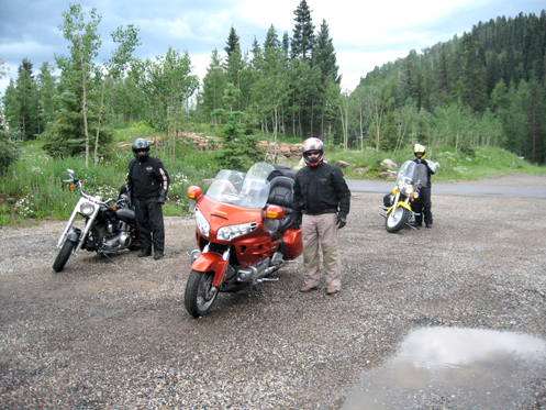
motorcyclists in the rain

Rain is why God invented rain suits–get one!

The weather could not have been better the last few days as we rode our motorcycles around southwestern Colorado. Fall colors were at their peak, the temperature was perfect, and the sunshine made it all completely glorious. Crossing Monarch Pass on the way out to Montrose from Denver had been a treat, and our ride over Red Mountain Pass, between Ouray and Durango, was even better than its usual spectacular.

Now it was time to head home and the weather gods had turned against us. We woke up at John’s house to rain and the weather radar showed unbroken storm clouds over much of the state, and over all of our route home. Time to suit up.

Right away Bill had a problem but it was easy to rectify. Bill was on his brand new Harley Classic, his first bike ever to have a fairing, and he had been over-optimistic as to how much protection that fairing would offer him. He had only worn a half-helmet and in a brief shower we’d ridden through a few days earlier he had seen the inadequacy of that arrangement. Fortunately John had an old full-face helmet he no longer used and it fit Bill, so that problem was solved.

As for the rain itself, hey, that’s why we have rain suits. Let’s roll.

Leaving John’s the sky seemed to be clearing, as if the storm might move ahead of us, but to the north, over Montrose, it was a lot darker. We headed for Montrose and rode into it. From there our route was east, so there was no chance we’d be parting ways.

There was a very noticeable absence of motorcycles on the road, and we’d probably been riding for half an hour before we saw any others. This may be prime riding season in Colorado but on a day like this the only bikes you were going to see were folks who had places they needed to be. Like us.

Riding in the rain makes for a very different ride. Slick curves can be dangerous, as can sudden stops, so the pace is necessarily more sedate. Oncoming vehicles can through waves of water over you, so you stay as far to the right as possible when they approach. Riding close behind a truck is a guarantee you’ll get soaked, so you don’t close up to traffic ahead, and if someone passes you quickly drop back behind them.

Cold and Getting Colder
Reaching Gunnison, we were dry but cold. Time to stop at a fast food joint for warmth and coffee. The thermometers on the Harleys read 40 degrees. Monarch Pass was ahead of us and it would be another 3,600-foot climb to the top. Would there be ice up there? Not a pleasant thought.

About a dozen other riders were stopped at the same McDonald’s for the same reasons, and when we came in they asked what direction we’d come, hoping for news of the pass. We had nothing to offer them. After awhile one group said good-bye, they had decided to find a motel there in Gunnison. Later, another group put on their gear and headed toward the pass.

While weighing our options, Dennis overheard a young woman speaking on her cellphone as she headed for the restroom. She was telling her friend about snow on top of the pass. We waited for her to come out and collared her, asking for details. She confirmed the snow.

We decided to cross our fingers and go for it. If we saw bikers coming the other way and they were waving their arms to warn us off we would heed their warnings. Otherwise we were optimistic.

There was no snow or ice on top of Monarch when we got there, and with the highest point on our route behind us the way home was clear. Yes, we had two more hours of cold rain ahead of us but we took our time and made a couple more warm-up stops.

Gearing up again after one stop in Fairplay, Dennis, who lives in the mountains in an area vulnerable to forest fires, remarked that it had damn well better be raining at his house considering that he was having to ride all day in the rain. At our final stop, at the turn-off Dennis would take to get home, I told him with confidence that I was sure it was indeed raining at his house.

Bill and I rode on to where our paths diverged and I headed home. At home it was only minutes before I was enjoying one of the best things a day like this has to offer: a long, hot shower. Now that is bliss!

Biker Quote for Today

You’d kill yourself on a bike? You mean your wife won’t let you have one.
First Ride Of 2019

Monday, January 7th, 2019
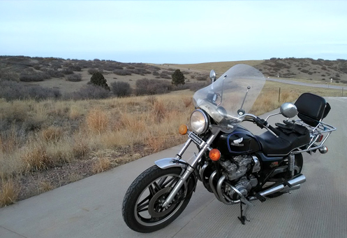
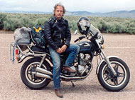
parked motorcycle

The Honda alongside Hess Road.

It wasn’t the first warm day in January but it was the first day when all the ice and snow were melted off our street so I could get out of the neighborhood on a motorcycle. I didn’t need a written invitation. I chose the Honda.

As is so often the case, I had no idea where I was going. I headed south and east but when I got to the road over Cherry Creek Dam my instincts rebelled. No! I go over the dam much too often! So I turned south on Dayton, alongside Cherry Creek High School.

At Belleview I turned east toward the park, and then south on Peoria down to Arapahoe. This is common ground, though usually in the other direction. So I continued south until Peoria became Broncos Parkway, then south on Potomac along the east side of Arapahoe County Airport, west on a disconnected section of County Line Road, then south again on Peoria to Lincoln Avenue.

Peoria then continues south across Lincoln Avenue, winds through a neighborhood, and comes out finally at Ridge Gate Parkway. Ridge Gate is quickly becoming a major road but it can’t be much more than two years ago that it was dirt. It runs from I-25 over to Parker. I headed east, in the direction of that once little town.

I was in explorer mode so when I came to a new housing development, called Stepping Stone, I turned south on Stepping Stone Circle and sure enough, it wound through the development but came back up to Ridge Gate. That’s fine, I was curious. Plus from that street I spied some other major road just a bit further east.

Ridge Gate, which was now Parker’s Main Street, took me quickly to what turned out to be Chambers, so again I turned south. At this point I could see the enormous earthen ridge of Rueter-Hess Reservoir so when I came to another new development, Heirloom, I figured it was likely that Heirloom Parkway would hook me up with Hess Road. It did, and I turned west on Hess.

Hess goes south and west until it hits I-25 at Castle Pines Parkway. I crossed the highway and continued west on the parkway but I knew it would take me to Daniels Park and I didn’t want to go there. I knew there was some road going north before the park if I could find it.

That turned out to be Monarch Boulevard and I headed north. Getting into the McArthur Ranch area the road becomes Quebec and I followed it all the way across C-470 and on up to Belleview, east on Belleview, and back home.

It was only about 38 miles and one hour’s riding but oh what a nice day to be out on a bike! The morning had been clear and warmer but I was busy, so once I was ready to ride it was clouding over and getting cooler. Nevertheless, my electric vest was all the extra warmth I needed and it was just delightful to be out.

Now I have two more bikes to ride in January but the weather is looking good all of the next week. I think I’ll get it done.

Biker Quote for Today

They say life is a highway and we all travel our own roads, some good, some bad, yet each is a blessing of its own. — Jess “Chief” Brynjulson

Lacking Part Of The Story

Monday, November 5th, 2018

Again, I didn’t know where I was headed. I’ll just have to find out.

Friday was nice so I needed to ride. I headed southeast on Parker Road. And I kept going.

By the time I reached Franktown I had a thought in mind. I would head over through Castle Rock, on over to U.S. 85 coming down from Sedalia. Then I’d turn up Happy Canyon Road and who knows where from there.

But as I cruised along I thought about Daniels Park Road. I’ve been up there numerous times and it was gravel north of the park. But I had read a while ago that they had paved that stretch of Daniels Park Road, so here was something new for me to explore. Decision made.

Turning off 85 onto Daniels Park Road it wasn’t long before I found myself coming up on a car that was stopped right in the road. What’s up? As I slowed down and drew near I saw the situation. There were three wild turkeys feeding almost right on the road on the left. The guy in the car had stopped to look at them, and who knows, shoot a few photos. He continued on when I came up behind him.

Then maybe just 100 feet further on I spotted a flock of about 12-15 more turkeys off on the right side of the road. Then a quarter mile further there were a bunch of deer lounging on the hillside next to the road. Who knew this was a nature preserve? Actually, I bet anyone who lives out there and tries to have a garden knows all too well. I live in the city and I have trouble with deer trashing my garden. These folks would have that problem in spades.

So I got on up to the park and immediately missed my left turn so I went just a little further and took advantage of a roundabout to make a U-turn. You know what’s amazing about this Rever map I’m embedding in this post? If you zoom in you can go all the way down and see my trip around that roundabout. GPS is amazing.

I got back on my intended route and quickly saw the changes since they paved, and it was not what I expected. For one thing, much of the newly paved stretch is one-lane divided. The northbound lane veers away to the right while the southbound lane veers away to the left. And man have they put up the fences. The whole stretch of road is flanked with what I think are commonly referred to as split-rail fences, except that instead of split rails they used round fence posts. And they put them in between the traffic lanes as well.

And then beyond those the whole area was lined with new six-foot wire fences, like someone wants really badly to keep deer or livestock off the road.

But then I got out of the park and hit Grigs Road, a T-intersection. To the right the road was paved but to the left–the way I wanted to go–it turns out it is still gravel.

Fortunately, I was on the CB750 and that old bike is a do anything, go anywhere sort of bike. Mostly the road was fine, though in places a bit dicey. I just took it slowly.

I got into the Highlands Ranch area, hooked up with Quebec, and headed north for home. Another nice November ride. And oh yeah, I had my winter gear on. It’s chilly out there most days now.

Biker Quote for Today

You’re a biker wannabe if you never ride to work.

Where Does This Road Go?

Monday, October 29th, 2018

You know I love exploring. Sunday was gorgeous so I got on the V-Strom to go enjoy it.

I didn’t know where I was going, and it gets tougher and tougher to figure out new places to go. I just headed south on DTC Boulevard.

I got to Orchard and thought about how I generally don’t go east on that road, so why not? Past Havana it gets into a neighborhood but comes out at Peoria, where you’re looking at Cherry Creek State Park. Go south.

Crossing Arapahoe and continuing south Peoria passes Arapahoe County Airport, bends east, and becomes Broncos Parkway. Sure I’ve been on this road before but not recently. And then when Broncos Parkway hits Parker Road, what then?

Well, at Parker Road, to keep going east means going into the Chenango development. Local streets. But I wondered, does it go through somehow and eventually end up at Smoky Hill Road? Time to find out. (The short answer is yes; the long answer follows.)

To say this road twists around a lot is an understatement. First it’s Jamison Avenue but then it bends south and you end up on Long Avenue. Wind and twist and twist and wind and after some time you end up at Ireland Way. This finally takes you out of Chenango and across E-470. I was a little turned around and thought I was heading east but the map tells me I was going more south-southeast.

Nothing to do but keep going, keep exploring and after heading a good way south I came upon Inspiration Drive. I’ve never heard of Inspiration Drive. Let’s go left, which I see for sure now is due east.

Inspiration Drive hits a T at Piney Lake Road, where I turned left–north. After hitting County Line Road it becomes Powhaton Road and pretty soon, sure enough, there’s Smoky Hill. So then it was just up Smoky Hill to Parker Road, to I-225, and home.

I knew I’d hit on some new roads when I got to all these unfamiliar streets. Also, as is often the case when I got exploring like this, I found myself several times on the edge of civilization. That is, there were large areas currently being bulldozed in preparation for new homes and schools and stores. Come back in a year and you won’t recognize the place.

Hey, did you have something better to do on this beautiful Indian summer day? I sure didn’t.

Biker Quote for Today

Weekend forecast: Motorcycle things with no chance of house cleaning or cooking.

Tracking Rides With Rever

Thursday, October 18th, 2018
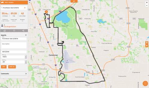
Rever tracking map

Viewing my first Rever ride from my desktop computer.

I was recently introduced to a new tool that I may very well put to a lot of use on this website. Brought to us by many of the same folks responsible for Butler motorcycle maps, we now have Rever.

Rever is a ride-tracking app for your GPS-equipped cell phone. In brief, you create an account, download and install the app, and then turn it on when you go for a ride. Shut it off when you’re done with the ride and you then have, stored in the cloud, a complete record of your ride, including route, miles, time, average speed, and more. That image above shows my very first ride with Rever tracking me.

It’s dead simple plus it has a variety of uses. Offered in a freemium manner as is so common these days, the basic app is free but if you pay to subscribe it offers a lot more. But at its most basic, you can track rides and also plan rides in advance.

Once you do a tracked ride or plan out a ride, you can save it. Any friends you are connected to on Rever can see your rides. So if you’re taking a group on a ride you have done before, or that you have planned out on Rever, each of your friends can open up that ride and they have the complete route plan right there in their hand.

One issue group riders encounter at times is getting separated. If each of your riders is on Rever and is tracking, lose somebody and you can pull out your phone, go to their rides, and see where they are right now. How cool is that?

For the paid membership you can also get Butler Maps overlays on your map so you can plan the route to hit all the good roads Butler points out to you.

What really interests me about Rever is that back when I built this www.motorcyclecolorado.com website we did not have smart phones that were essentially desktop computers in your hand. But full-sized web pages don’t generally display well on a cell phone. In order to at least not get too far behind technology I have rebuilt the main pages of the site to be mobile-friendly, but that’s only 11 pages out of more than 100.

Of course, the main point of the website is to present the best rides in Colorado. I have created maps but they are static. You can’t zoom in or do anything else other than look at them. With Rever I see the opportunity to create new, mobile-friendly pages for all these routes that should really bring the site more up to date. So look for that to happen over the next couple years.

Meanwhile, in order to present all these routes via Rever maps, I’m going to have to ride them all again. Oh, what a dirty job. Please don’t throw me in that briar patch.

Biker Quote for Today

If you think I’m cute now, wait until you see me on my motorcycle.

OFMC 2018: Cold And Big Winds On Final Couple Days

Thursday, September 13th, 2018
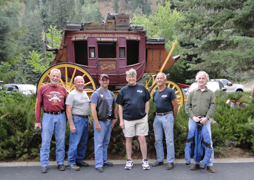
OFMC group shot

From left: Bill, Dennis, Brett, John, Friggs, me.

For once on this trip we did not need or want to get an early start, so we got to sleep in a little. Our ride for the day was to be short and we were still hanging with John. It was cool departing but Dennis pulled over within 10 miles to shed a layer, and it quickly got warm.

It was a quick ride to Montrose, then east on U.S. 50. This is a nice ride, with hills and curves, and comes over Blue Mesa Summit to the Blue Mesa Reservoir. We then rode the rest of the way into Gunnison and stopped for lunch.

The weather changed dramatically while we ate. Leaving Gunnison the sky was very threatening and the winds were whipping. I suggested we should try to outrun the weather. Whether or not that was Bill’s intention, he took off and rode hard and fast up the valley. Meanwhile the wind beat on us with malice, with dust so thick at times we could hardly see and gusts shoving me several feet to the right on a number of occasions. This was the only time on this trip I wished I was on the Concours. Those extra 200 pounds would have provided welcome stability.

Whether we outran the weather or just got lucky, by the time we got to the mountain the extreme winds were past but then it got gusty going up the mountain. It also got cold. We blasted up and near the top of Monarch Pass the wind kicked up substantially again and at times it was not one bit of fun. We got over the top and kept on pushing hard but now it was the weather ahead that looked really bad. There was serious wet up ahead. After a stop at Poncha Springs, however, it appeared the wet had already made its way east of our route. I put on my rain jacket for the warmth but it was not needed for dryness. Winds buffeted us at times as we made our way north on U.S. 285 to Buena Vista—our day’s destination—but all in all it was a good ride.

Next day it was homeward bound. The last day’s ride home is almost always anticlimactic. With just 120 miles to go there was no need to hurry; all we felt we needed to do was get home before the afternoon rains began. It was cool so we wondered how warmly we needed to dress but we were getting gas on the outskirts of town so the ride there would give us some idea. And yes, we put on more layers.

Then it was off toward Fairplay and once again the sky was threatening. What’s more, the temperature was dropping. That 35 miles to Fairplay was a chiller! I didn’t know if Dennis, in the lead, was planning to stop there for more warmth but I definitely was. Fortunately, Dennis pulled over at the first opportunity and we all bundled up. It was cold!

Taking off again, Dennis noted that there was probably no reason to stop again. So we rode on to Conifer and he dropped off, then on down to where 285 hits C-470, at which point I went straight and the other guys turned north. My last few miles through the city were now pretty warm but not enough to prompt me to stop and peel off layers. At home I quickly shed the warm gear and sighed a happy smile to be home, with intentions of staying there, after three weeks on the road.

Biker Quote for Today

Sorry, I’m busy. I have to ride my bike.

The Bikers I’ve Seen Lately

Thursday, August 23rd, 2018
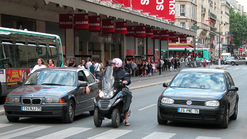
lane-splitting

Lane splitting and filtering as practiced in Paris.

Three times over two days recently I observed some interesting people on motorcycles.

I was up in the hills and had no intention of coming down on I-70 but a wrong turn left me doing exactly that. I was in no hurry and so I kept to the right lane, where I got passed by a couple guys in a bigger hurry than me. They were something to see.

These two guys were obviously traveling because their bikes–Harleys or something similar–were totally loaded with gear. But I’m not talking big bags on the sides and a big top bag. No, they had all their individual items bungeed on all over the back ends of their bikes. And they had a lot of gear.

They were barreling along the interstate and neither of them had a riding jacket on. Both were wearing sleeveless t-shirts, although they were wearing helmets. And on top of each helmet was a GoPro camera.

Yeah, they were an interesting sight.

Further along the way home on this same ride, I was coming east through town on Hampden and it was rush hour. Or crawl hour, more appropriately. I was aware of the traffic around me so it was with some surprise that I glanced in the mirror at one point to see there was another bike right behind me in my lane. Where did that guy come from?

I barely had time to wonder if perhaps he lane-split his way up behind me when the traffic came to a complete stop and he blasted on ahead, going up the middle. Question answered. Lane-splitting is not legal in Colorado but that obviously did not bother him.

Then the next day I was once again on Hampden, this time headed east near Kennedy Golf Course, when I came to a stop at a red light. In front in the left-hand lane was a guy on a sportbike. A big pick-up was in front of me, first in line, and to our right a small orange pick-up, with a riding lawnmower in the bed, pulled up first in line.

But this was no ordinary pick-up. This one had no hood because the engine stood up about a foot above where the hood would have been. And this guy was revving his engine, clearly planning to blast away as soon as the light changed.

The light did change and whether there had been some communication between them or what, both the bike and the orange pick-up rocketed away. Most likely, the biker decided it would be fun to shut down this orange guy, whose intentions were clear.

I quickly lost sight of them both because of the guy in front of me, but as we neared Havana, where the road curves hard to the left, I caught sight of the bike going about 70, screaming around the curve with no orange guy anywhere to be seen. I’d say the biker definitely shut down that orange guy. Just having fun, you know.

Biker Quote for Today

If you can park it and not turn around to admire it before walking away you bought the wrong one.

Great Rides: Cross The Continental Divide On Trail Ridge Road

Thursday, July 12th, 2018
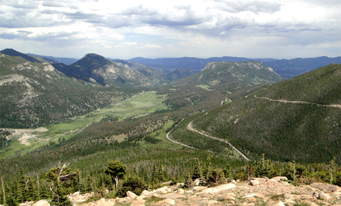
view from Trail Ridge Road

From an overlook on Trail Ridge Road.

You climb through the Big Thompson Canyon heading west out of Loveland with the river crashing down through this jagged granite gorge. Worthy of the ride all by itself, the canyon is just the appetizer as U.S. 34 continues through Estes Park and then the entrée is served: Trail Ridge Road.

Crossing Rocky Mountain National Park over the Continental Divide, Trail Ridge Road is the highest continuous motorway in the United States and a must-do ride for motorcyclists coming to Colorado. Reaching 12,183 feet at its highest point, the road stretches for more than 8 miles above 11,000 feet, well above timberline and offering spectacular views and its own brand of weather.

Warning to bikers: Do not dress for summer on this ride, even if it is blazing hot down lower where you’re starting out from.

You enter the park and loop around West Horseshoe Park, passing throngs of tourists with cameras blazing away at a flock of bighorn sheep. The sky is blue above but the dark, threatening clouds you’ve been eyeing all morning sit ominously to the south. Keep going.

But you can’t ride this road without stopping, so you pull over at several of the many turn-outs, especially Rainbow Curve, where the entire valley and the winding road you’ve just ridden are laid out below you. This is why you brought the camera.

The climb continues and then you’re above timberline, and two things demand your attention. First, the road is torn up for resurfacing, leaving loose sand and gravel in many places and just generally lousy road everywhere else. Second, the wind has picked up, that threatening cloud is now not far away at all, and the temperature has dropped about 20 degrees. Time for extra layers and gloves.

You loop along above timberline, through broad sweepers, up and down tundra-covered hills, and through a narrow notch cut through rock on one particularly steep curve. You’ve now passed the highest point in the road, and coming around a curve you descend a bit to the Alpine Visitor Center. Time to go inside, get warm, and have a bit of lunch.

Sitting in the restaurant at a table by a window you peer down the steep drop below you, watching a marmot scamper across a snowfield that never melts. Clouds the color of a nasty bruise now hang directly overhead and it would be raining except that it’s too cold to rain. Instead, tiny frozen raindrops tinkle against the window and ricochet off the rocks below you.

Forty-five minutes later the valley below you is completely obscured by clouds but overhead the sun is trying to poke through. You head back to the bike and pull out the rain gear because the road is now wet and there are still clouds to be wary of.

Down you ride, around Medicine Bow Curve, and then you parallel a canyon far below for several miles. Just over Milner Pass there is a crowd pulled over and there are elk with huge racks grazing and sparring. Time again for the camera.

From there the route is down, down, and down, and you exit the park. The town of Grand Lake glides by as do Shadow Mountain Lake and Lake Granby. U.S. 34 ends just west of the town of Granby, where it meets U.S. 40. From here its either west to Steamboat Springs or east over Berthoud Pass and back to Denver. East it is.

Biker Quote for Today

I ride because when everything in life is wrong it’s the only thing that’s right.