Archive for the ‘Colorado motorcycle rides’ Category

Making Sense Of Express Lanes

Thursday, July 8th, 2021

When Colorado opened its first high-occupancy vehicle (HOV) lanes it was easy: if you were on a motorcycle you could use them and you did not have to pay. There was a brief period of confusion when they said even a motorcycle needed a transponder but thanks to the efforts of groups like ABATE of Colorado that requirement was eliminated.

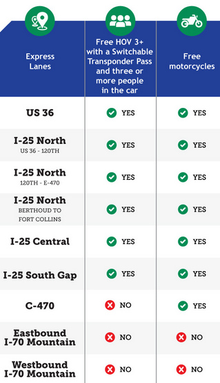
Here’s what motorcycles can ride for free.

In the meantime, though, there has been a proliferation of roads that are tolled in one way or another and because I was personally so confused over which ones I could ride on a bike I just quit using any of them. I decided it was time to clear up this fog, so that’s what I’ll do as best I can here.

One of the clearest bits of information is found in that image here of a portion of a chart found at https://www.codot.gov/programs/expresslanes/using-the-lanes. Basically, what this is saying is that all of the express lanes on I-25 and the lanes on US 36 to Boulder are free to motorcycles at all times. And they’re also saying that the express lanes on I-70 into the mountains are tolled no matter what vehicle you are in or on. E-470, of course, is a toll road for everyone.

Another good resource is this CDOT page: https://www.codot.gov/programs/expresslanes. On this page, in a section called WHERE EXPRESS LANES ARE, AND WHERE THEY’LL BE, there are links to maps showing you exactly what roads they’re talking about. I mean, heck, do you know what road they mean when they talk about the I-25 South Gap Project? I didn’t.

There is also a downloadable fact sheet here: https://www.codot.gov/programs/expresslanes/assets/motorcycles-express-lanes-fact-sheet.pdf

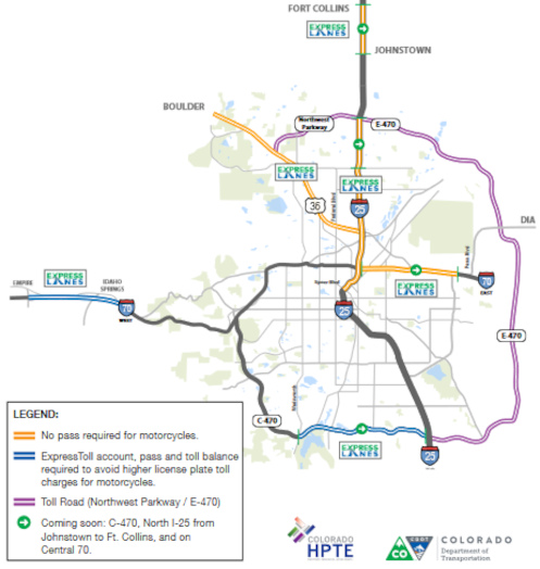
This is especially good except there seems to be a discrepancy. Here’s the map on the first page of this PDF.

This map does not agree with the other information in one spot.

See down there on C-470, where it’s blue. The legend says “ExpressToll account, pass and toll balance required to avoid higher license plate toll charges for motorcycles.” But the chart says C-470 is free for motorcycles. And on this page specifically about C-470 it says “Motorcyclists can use the Express Lanes for free without a pass.”

So I’m a bit confused, although I tend to suspect the map is wrong and you can ride C-470 with no issues. If anyone can confirm or refute this conclusively PLEASE let me know. Thanks.

I hope this clears most of this up for any of you who, like me, was unclear before. I guess I’ll start using the express lanes again.

Biker Quote for Today

All my friends have life goals . . . and I just want to go faster.
An Unlikely Contender For Offroad Fun

Monday, June 28th, 2021

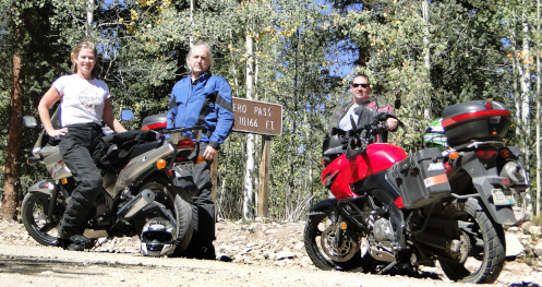
Kevin and I were on V-Stroms but Janet rode her Ninja.

Sometimes the best tool for the job is not the one designed for that purpose, but the one – the only one – you have.

Take dual-sport riding, this business of taking a motorcycle down the highway to get somewhere, and then taking that same bike onto the dirt when you reach your destination. Years ago, when motorcycles were less specialized than they are today, riders were far more ready to take their street bikes in the dirt. Nowadays we have dirt bikes and dual-sport bikes, and most street bikes never see more than a short stretch of gravel here and there. Many never see anything but pavement.

I went dual-sporting awhile back in the area around Gunnison. The two Suzuki V-Stroms we were on were provided by my friend Kevin, who used to rent V-Stroms out of Gunnison. And there was a third person with us, Kevin’s wife, Janet, and she was riding her Kawasaki Ninja 500R.

The Ninja is a sportbike, the antithesis of a dual-sport or dirt bike. Whereas the V-Strom has 6 inches of suspension travel in the rear, the Ninja is limited to 3.9 inches. On rough roads those 2 inches make a huge difference. And ground clearance on the Ninja is only 4.9 inches, compared to 6.5 inches on the V-Strom.

We headed out of Gunnison on the highway, went up and over North Cochetopa Pass, and then coming down the other side we turned off on an unpaved county road. It was pretty good gravel, hard packed and stable, and well maintained. The V-Stroms, like any good dual-sport bike, were right at home. And the Ninja just cruised along, too.

As we began to climb up to Carnero Pass things got a bit rougher. There was washboard, a few ruts, and some stretches of badly disturbed surface. The V-Stroms ate it up. The Ninja took it slowly, navigating around the bigger holes, following the smoothest path. Not a problem.

Over the top and down and we followed a ranching canyon to its outlet onto the prairie. The road was once again good hard-packed gravel. Then we turned onto an unpaved county road that was broad and flat . . . and deep in loose gravel.

“That sucked!,” Janet said when we stopped in town. “That mountain road was fine. I had no problem with it. On that flat road I didn’t feel comfortable going above 40. I knew that if I screwed up it would hurt.”

“Deep, loose gravel is hard, I don’t care what you’re riding,” Kevin replied in agreement.

So the rougher, less-maintained road was really better for the Ninja.

“The suspension on the Ninja was fine. I absolutely felt confident on it. I feel very maneuverable on that bike. I can move it anywhere I need it to move to avoid obstacles in the road,” Janet explained.

That said, she added, “I’d rather be on the (paved) road.”

Janet is a serious mountain bike rider, but has only started riding motorcycles in recent years. She chose the Ninja because it was one of the only bikes she could handle considering how short her legs are.

“Now I’m thinking, ‘Oh, I want a dirt bike because I want to start doing all these gnarly roads around in the mountains.’ I want to get up in there without having to be in a car. It just catches me off guard because I didn’t expect motorcycling to get under my skin. And when I ride it gets under my skin. When I’m not riding I’m like, ‘No I don’t want to do that, I want to ride my bicycle.’”

Janet has taken her Ninja over other mountain passes on gravel roads. “It’s the only bike I’ve ever had. If I want to go somewhere it’s the bike I ride.”

It’s just that simple. For Janet, it’s the best tool for the job.

Biker Quote for Today

I need men for some things; riding a motorcycle is not one of them.

Found A New Road

Thursday, June 24th, 2021

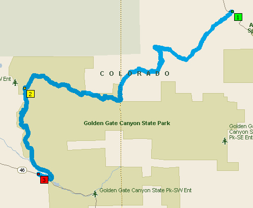
You can’t see the detail with the map zoomed out this far but you won’t have any trouble finding the roads.

Don’t you love it when you find new roads to ride? Of course you do. So do I.

Well, this one does require that you be willing to do a little gravel but it’s good gravel. Heck, I’ve even ridden my Concours, which notoriously hates gravel, on part of this stretch once before. But no question it’s better with the V-Strom.

Judy and I wanted to get up in the hills away from the heat the other day and we headed up Golden Gate Canyon Road out of Golden. There’s a point where you come on a small lake or pond–Kriley Pond–just a short ways before you get up to the Peak-to-Peak. Immediately past the pond you’ll see a dirt road going off to the north. Take it.

This is Mountain Base Road and it takes you along the western edge of Golden Gate Canyon State Park, just inside the park. This segment is just 3.5 miles to where you hit County Road 2, also called the Gap Road. Turn right onto Gap Road.

One of the first things you’ll come to on Gap Road is Panorama Point. This is a high spot where the view is expansive, and there’s a viewing structure as well as toilets here. Be advised that you are in the park and while there is no park fee for using the roads, if you stop you are technically required to get a day pass, for $10. So use your own discretion if you choose to stop.

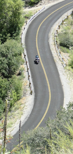
Heading east on Gap Road it only stays gravel for a couple more miles and you hit pavement. And where do you suppose this pavement brings you out? In Coal Creek Canyon. Who knew there was a road connecting Golden Gate Canyon and Coal Creek Canyon? I sure didn’t. And It’s a really nice road, very scenic, very pretty. Also very twisty.

The total distance is only 11.8 miles, of which roughly half is very good gravel, the rest excellent asphalt. Not a big deal but hey, when you’ve ridden pretty much every road in the area multiple times it’s really nice to find something new.

Biker Quote for Today

An intellectual is a man who doesn’t know how to park a motorcycle.

A Good Day To Ride, And An Answer

Monday, June 21st, 2021

I’ll get to the answer first. I asked last week if anyone actually uses the RSS code in the sidebar and I got an answer. Yes. There are at least some people who still do, and the code apparently is still working. So I won’t be deleting it. Good to know.

Riding the East Portal road at Black Canyon.

If there is one thing motorcyclists recognize when they see it it’s a good day for riding. Saturday was one of those days and we were out in force.

The RMMRC did a ride and it was finally not in the high 90s temperature-wise. Then we went up in the hills and it was downright cool. How welcome that felt!

Starting out from the Phillips 66 in Morrison, a dozen of us, broken initially into two groups, crossed over past Red Rocks to Golden and then headed up Clear Creek Canyon. Through the vagaries of traffic we ended up in one group in spite of ourselves as we made our way up to Idaho Springs and lunch. One of the older members of the group remarked at lunch that he believed that was the first time he ever rode up Clear Creek but I find that too hard to believe. You don’t live in Denver for decades and never go up that canyon. Especially if you’re a motorcyclist.

One thing I found puzzling in the group I started out in was that the leader, who was not Bob, acted very Bob-like in that he took the lead position in the right side of the lane. I know Bob does that, and I finally got an explanation from him as to why, but here we go again with someone else. Isn’t it the norm that the leader takes the left position? Not for everyone, apparently.

Leaving Idaho Springs we gave up on breaking into groups and just headed out en masse. We ran up and over Squaw Pass. Although I’ve done Squaw Pass many times, I rarely go west to east, which is what this was, so it was pretty interesting. I’ve heard it said that going the other way on the same road is like taking an entirely different road and there is some truth to that. That kind of doubles your options so things don’t get too same old, same old.

Reaching the Evergreen Parkway near Bergen Park we split, with some heading south to Evergreen and the rest of us jogging north to the turn-off to Kerr Gulch. That is so much nicer than fighting the traffic in Evergreen. Then Idledale, and back to Morrison, and each in his own direction. Nothing special about the day, other than it was a really nice day to ride and everyone recognized it.

Biker Quote for Today

A truly happy person is one who can enjoy the scenery while on a detour.

‘Roads To Cripple Creek’ Added To Website

Thursday, April 22nd, 2021

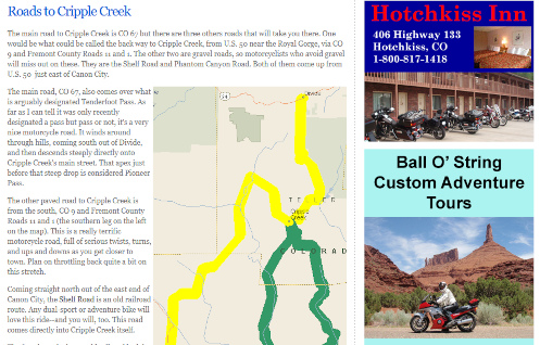
A portion of the new Roads to Cripple Creek page on the Passes and Canyons website.

For the first time in quite a while I have added a new page to the Passes and Canyons: Motorcycle Touring in Colorado website. The new page focuses on the numerous good motorcycle roads that lead to Cripple Creek, and I have named it “Roads to Cripple Creek.”

I don’t add many pages to the site these days because I’ve basically got it built out. It’s not like the roads in Colorado change all that often. I did add a new page for Guanella Pass when they finally paved that road all the way. But that’s not a common occurrence.

I first started thinking about Cripple Creek when I read somewhere that the high point of the road coming into town from the north, from Divide, is considered Tenderfoot Pass. If it’s a pass, I figured, I ought to have it on the site. But it’s kind of iffy as a pass. There is some more or less official registry of geographic place names in the U.S. and Tenderfoot Pass is not included on this list. And as many times as I have been over that road I never thought of it as a pass.

But then I got to thinking. While the road out of the north does have some good twists and turns, and goes up and down, and has some terrific views in places, it’s really probably not the nicest motorcycle road to get to Cripple Creek. There are others I would rate higher. So how about a page focusing on all of them. That’s what I did.

The other paved road into town is generally considered the back way, coming up in a roundabout manner from U.S. 50 a bit to the west of the Royal Gorge. If you’ve never been on this road you really need to do it. It has some terrific twists and lots of changes in elevation. Definitely better than the main road.

Then there are two gravel roads, both along old railroad beds. One comes directly into Cripple Creek, and that’s the Shelf Road, which comes north out of Canon City. Then the Phantom Canyon Road comes north from U.S. 50 a little to the east of Canon City and runs up to Victor, which is just a few miles east of Cripple Creek. Both of these are really nice, scenic road and are ride-able on street bikes as long as your bike is OK on decent gravel. For instance, I would not hesitate to take my Honda CB750 on them, but I would never consider riding them on my Kawasaki Concours. And of course, my Suzuki V-Strom loves that kind of stuff.

The page is not yet complete; I still need to add photos of these four roads. I have some already and just need to add them. For the others I’m going to have to go ride these roads again and get some shots. Oh the horrible burdens I bear!

Biker Quote for Today

The ride keeps me sane. I would like to call it my church.

A December Ride With The RMMRC

Monday, December 21st, 2020
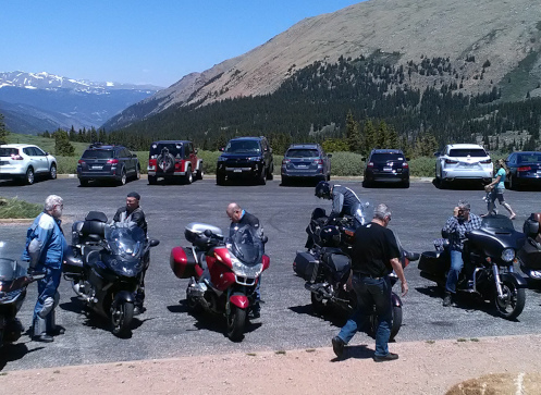
RMMRC On Guanella Pass

The RMMRC on top of Guanella Pass back when the weather was a little warmer.

I thought the RMMRC had decided to suspend all group rides until the peak of the virus had passed so I was surprised to get an email from the Meetup page about a ride two Wednesdays ago. So I went riding.

It was no big deal, just another run out to Patty Ann’s in Kiowa for brunch. But on a nice day Patty Ann’s is a good place to gather. They have a large patio out back where we can sit not too close together in the open air. And they have really good food.

We were surprised when we got there to see that they have installed tents to shelter you from the weather and to maintain separation between different parties. That didn’t really suit us, though. First off, it was a little cool and we wanted the sun. Secondly, whereas a family might sit together in one tent, close to each other but no one else, we wanted to maintain distance amongst ourselves. So we moved two tables out into an open area to meet our wishes. And then of course we moved them back before we left.

So the RMMRC is going through some realignment these days. Robert, this year’s president, has moved to Panama so that spot needed filling. Robert was also one of the most active organizers of rides so other people need to step up.

Roy, one of the founders of the club, takes a personal interest in seeing it continue so he has personally taken to urging greater involvement of other members, which definitely means he has turned some of his focus on me. Every time we talk he urges me to offer any ideas for rides that I might have. And I do have an idea I intend to offer.

In the case of this ride he threw out the question of who wanted to lead. As he scanned the group his eyes lit on me and he said, “How about you, Ken?” Bob, who often leads, said he would do it but he only knows one boring route. I said I knew a different road. So I lead the ride down to Kiowa. It was a simple route, just out Parker Road (CO 83) to Bayou Gulch Road, just south of the south entrance to the Pinery, which leads to Flintwood Road, which we took south to CO 86 and then east to Kiowa.

Then on the way back we didn’t want to take the same route in reverse so someone suggested we go back to just past Flintwood, like about 100 feet past Flintwood, and take that road, Deerfield Road, to Russellville Road to CO 83. Somehow I got designated to lead again, so I did.

In all there was nothing at all extraordinary about this day’s ride. But it was a heck of a nice day to be out on a motorcycle and clearly the transition to new leadership is underway for the RMMRC. I’m happy to do my part.

Biker Quote for Today

Just one more motorcycle . . . I promise.

Making My Own Fun

Thursday, November 19th, 2020
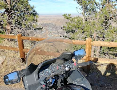
View from Lookout Mountain

Looking at the north end of Golden from the parking lot of Buffalo Bill’s grave.

We’ve had some really nice weather the last couple days so I had to go ride. Normally, with Wednesday forecast for a high around 72 there is no question there would have been an RMMRC ride. However, with the coronavirus flaring up in a big way, the RMMRC sent out a note earlier this week that for the time being all rides and events are suspended. I guess I’ll have to do this on my own.

It’s times like this when I get antsy to move somewhere else. I’ve been out on the plains way too much lately but going to the hills means riding half an hour across town both ways. It makes me jealous of Bill, who lives right alongside CO 93 running up from Golden to Boulder. He gets on his bike and he’s in the hills in five minutes.

But I did head west. I took Hampden/US 285 to C-470 and got off at Morrison. I was going to run up that road to Kittredge on CO 74 but just like the last time I tried that the road was closed. I figured the work they had been doing several weeks ago would be finished, but no. Wonder what they’re doing?

So I took the Hogback Road that runs up past Red Rocks, under I-70, and turned left onto old US 6 up through Mount Vernon Canyon. I wasn’t sure yet where I was headed but about this time I decided I’d take the turn-off over to Lookout Mountain and the Buffalo Bill grave site. That’s a nice road and you get several stunning views of the plains laid out below.

I stopped at Buffalo Bill’s to get that photo above and then headed on down. What I was already surprised at was how many other people on motorcycles had the same idea. Also, not a surprise, there were at least as many people on bicycles.

I started heading down and came up on a guy on a bicycle. I could have passed him but I’ve seen these folks on hills like this. I figured he’d actually want to go faster than I did. I was right. We neared the first sharp curve and he started scorching. Within seconds he was gone. I was in no hurry.

So I cruised on down, waving to any number of other bikers coming up, and then suddenly two bicyclists went blasting past me. Holy crap! I hadn’t been looking in my mirrors because what was there to look for? And I got passed one more time before I got to the bottom.

A note: the lower end of the Lookout Mountain road has been newly paved and they have added four speed bumps in the area where there are houses around.

I got down to CO 93 and one of the first things I saw was a motorcycle cop, and this guy was wearing just a short-sleeve shirt. I had a tee shirt, a flannel shirt, a vest, and my leather jacket. That’s how warm it was. Beautiful day in November.

Then from there I just headed home.

Biker Quote for Today

You know you’re a biker if you don’t go a day without wearing something that says “Harley Davidson.”

Ripple Creek Pass

Thursday, November 5th, 2020
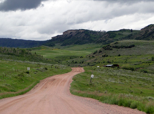
Ripple Creek Pass

Ripple Creek Pass is beautiful but not the kind of road you want to take a highway bike on, unless you’re very adventurous.

In the early days of the OFMC we were still exploring the roads around Colorado. Nowadays we’ve been pretty much everywhere so it’s rare to find ourselves on new roads, although it does still happen on occasion.

One early experience we had, that turned out to be something we did not expect, was Ripple Creek Pass.

John and Bill and I were headed to Utah on our bikes. Having been that way so often before, John, our master of maps, was looking for a route we hadn’t been on. He found it in Ripple Creek Pass.

Colorado 131 comes down from Steamboat Springs to hit I-70 at Wolcott. About midway on that route, at the small town of Yampa, the Flat Tops Trail Scenic Byway heads west, crossing over Dunckley Pass and Ripple Creek Pass as it skirts the Flat Tops Wilderness. At its western terminus, 65 miles away, the road comes out to Meeker, along CO 13.

“Let’s take this road,” John said. “There’s about 10 miles of gravel but it shouldn’t be too bad, and the country we’ll be going through should be spectacular.”

Bill and I were game, so off we went.

Heading out of Yampa the road was good, smooth gravel, the kind you can ride a street bike on all day with no problem. We wound over some hills and through some ranching valleys, enjoying the high plains beauty of western Colorado.

Then the road started climbing, and it also started getting rougher. Washboard became the norm, not the exception. This was the kind of surface that dual-sport motorcycles are made for, but not street bikes. No big deal; we can handle 10 miles. Except, hadn’t we already gone almost 10 miles? That pavement was going to look good.

The further we rode, the more civilization gave way to nature. Pine forest and mountainsides replaced grassy valleys, and we continued to climb. The washboard continued, the miles passed by, and the fillings in our teeth were in danger of being shaken loose. We were well past any 10 miles by now.

Up over Dunckley Pass we rode and down the other side. The origin of the name Flat Tops Wilderness was evident in those un-pointy mountains to the south of us. Heading up Ripple Creek Pass, this was nature at its grandest but by now our minds were not so much on the scenery as on the seemingly endless miles of rough gravel. Our master of maps had read this one wrong.

Along the way John went down on his brand new Honda Shadow. He was leading and decided to pull over and ran into deep sand. That’s why it’s good to have buddies along when you’re riding this sort of road.

Over Ripple Creek Pass we fared and down to Buford, where the long-awaited pavement finally showed its face. We had ridden fully 50 miles on gravel that was now smooth, now wretched. Our faith in John’s map-reading skills was tested sorely. But for now, let’s just burn up some miles.
And don’t go proposing any unpaved roads again anytime soon.

Biker Quote for Today

We know you’re a poser if you don’t own a rain suit.