Posts Tagged ‘Colorado motorcycle rides’

Cruising Colorado with the OFMC

Monday, July 25th, 2011

OFMC on the side of Grand Mesa

The OFMC is off on its annual trip and we’re mostly doing Colorado again. We have, however, dipped down into New Mexico, spending last night here in Chama and tonight outside of Espanola. Then it’s back to the home state.

It started like a river, with a stream that met other streams and grew. Four of us left Denver Friday morning, met up with a fifth in New Castle, and then were joined there by two more. Yesterday our eighth member met up with us here in Chama. We have taken some of the main roads everyone takes and we have gotten off on some smaller roads many of us never knew existed. For instance, did you know that behind the hills that New Castle and Rifle back up to there are roads connecting those communities? They’re country roads going through some nice country and they’re a great alternative to the interstate.

We also wanted to avoid U.S. 50 down from Delta through Montrose and on to Ridgway. That one-time two-lane road is now a four-lane expressway and no fun. So John led us on CO 348 which winds through the Olathe corn country. How that road came to be considered a highway I have no idea. It zigs and zags like a ragtag bunch of country roads someone, for a joke, decided to call a “highway.”

Saturday night in Telluride was a hopping place. The place we had reservations screwed up, despite John having called two days before to confirm his reservations, and had us down for one room for two nights. No, we needed two rooms for one night. So they opened up what we took to be a private condo in the place and three of us who had that room had one of the fanciest motel rooms we’ve ever had.

Yesterday it was on over Lizard Head Pass, through Durango and Pagosa Springs to where we turned south into New Mexico, to here. Today it’s back toward Antonito over Cumbres Pass and then we’ll head right back into New Mexico. We’re taking a roundabout route or else today’s ride would be only 75 miles and not all that interesting.

Time to go ride.

Recent from National Motorcycle Examiner
On the road with the OFMC

Biker Quote for Today

Officially old enough for an Electra-couch.

All Motorcycle Maps Are Not Created Equal

Thursday, July 14th, 2011

It was not a motorcycle trip but my wife, Judy, and I were out running around the mountains last weekend and had a chance to really compare some maps I had brought along. We were in her new Subaru Forester, which is an all-wheel-drive vehicle with high clearance, so we wanted to do some dirt, and take some roads we hadn’t been on before.

Motorcycle mapsI brought along three maps that I figured would be useful. One is the Colorado Motorcycle Skill Rating Map that was put together largely by ABATE of Colorado and the Motorcycle Roadracing Association for the Colorado Department of Transportation (CDOT). Another was the Colorado Bicycling and Scenic Byways Map, also produced by CDOT. The third was the Butler Motorcycle Maps Colorado map.

With Judy playing navigator, I drove. We went over Ripple Creek Pass, on the Flat Tops Trail Scenic Byway, which runs from Yampa over to Meeker. Later we went partway back along that road to Buford and took the Buford to Newcastle Road. Then we drove the Colorado River Road from Dotsero to a little north of State Bridge on CO 131, and finally over the Trough Road, which runs from State Bridge to Kremmling. The first two are rough roads that you would not want to take a street bike on (though we have in fact ridden the Flat Tops Byway on street bikes–bad idea!), while the other two are just fine for street bikes.

All in all, we had a great time, saw some great scenery, and gathered a lot of information that will eventually end up in the Dirt Roads section of this website. What I hadn’t really thought about, though, was what a good test this was for the maps. They all three were helpful in their way, but the word from the navigator is very clear: The Butler Maps Colorado map is the best.

What that means, very simply, is that the one you pay money for is better than the two free ones. That stands to reason, and is appropriate, but of course was not something you could just assume. But we put them to the test and that’s the verdict. And let me make the point here as well that this is not a verdict biased by the fact that Butler advertises on this site. I’m not sure Judy is even aware of that. She just switched back and forth between the three again and again and at one point told me in no uncertain terms that I should tell everyone that the the Butler map was the best. So there you go. I’ve passed the word along.

Recent from National Motorcycle Examiner
Piaggio MP3: A parallelogram of wheels

Biker Quote for Today

I’m slower than a dude riding one-handed on a DR350 while running a video camera. -Bk.Rd.Rnr

A Cruise Up Mount Evans

Monday, June 13th, 2011

Atop Mount Evans

On a beautiful day like today I had to get out and ride. Plus, I owed an article to one of my editors and figured a piece about riding up Mount Evans would work just fine.

I know it can get cold up there, even when it’s warm down here in the city, so I put on long underwear and a turtleneck shirt. I also put on my electric vest but waited to turn it on until I needed it. Then I had other warm clothes in my bags.

Man, was I roasting before I got out of town. Getting up onto CO 103 over Squaw Pass it finally started getting cool and that was a welcome relief. I reached the turn-off to the mountain, up by Echo Lake, and wondered if I would hear what my friend Dom was told when he was up there just two days earlier, which was that it was so windy they didn’t recommend riding a bike to the top.

Nope, no such warning, and clearly none was needed. They did warn me about frost heaves at the 9-mile marker, near Summit Lake, but I know about those. Just think of them as whoops and you’ll be fine.

So I cruised on up and it was a glorious day. Sunny and warm, I never turned on the electric vest. The view of the Sangre de Cristos from the top was unbeatable. They just went on forever.

Of course, I don’t think you can ride this road without seeing at least one person going down so scared of the sheer drop-off on the edge that they straddle the center line. And I will note that there was one place where the asphalt was just dropping away over the side. Even I stayed close to the middle along that stretch.

And then it was home again. Nothing much, I just rode to the top of the world and back home, all in about five hours. What did you do with your day?

Recent from National Motorcycle Examiner
Willie and Harley: Two American icons tour together

Biker Quote for Today

Any motorcyclist caught holding up automobiles on a winding road will be forced to sell all fringed accessories, buy plaid pants and take up golf. — Peter Egan

Wazzup? Getting the Word Out On Colorado Motorcycle Events

Monday, March 7th, 2011

Blue Knights compete

It occurs to me that someone might be reading this blog and not know that it is, as the tagline says, “companion” to the motorcyclecolorado.com website. And it’s also possible that someone might know that, but never have looked at the website to see what it offers.

Now, as far as that goes, I’m only going to say that it features all the best motorcycle roads in Colorado. But it does more than that. It also lists some recommended motorcycle-friendly motels, hotels, B&Bs, what have you. It lists dealers and repair shops. If offers riding stories telling of people’s adventures in Colorado on motorcycles.

And it lists upcoming motorcycle events in Colorado. That’s what I want to talk about here.

On the “Colorado Motorcycle Rides, Runs, and Rallies” page I keep as current a list of upcoming events as I can. I may get a little behind in removing events that are past, and I know I don’t get everything listed, but I do what I can.

So here’s my pitch. If you have an event coming up, take a look at the Rides and Rallies page and if you’re not already on there, send me the info and I’ll get it up. You can see what kind of information I present, so it’s especially nice if you send it to me in that format.

One important note: The website only features events in Colorado. Please don’t send me something that is not in Colorado.

If you want to promote your event, having it listed here is a good move. It doesn’t cost anything and that particular page gets a lot of readership. In fact, it is always one of the top five pages on the entire site. Within the last year, it was visited 7,173 times.

And I guess there’s no better time or place than right now to thank all of you who have already made it a point to notify me of your events. I do appreciate it.

Recent from National Motorcycle Examiner
Only a biker knows . . .: Motorcycle wisdom, #16

Biker Quote for Today

The letters “MC” are stamped on your driver’s license right next to your sex and height as if “motorcycle” was just another of your physical characteristics, or maybe a mental condition.

My Role as Facilitator

Monday, August 23rd, 2010

Pikes Peak International Hill Climb

Here’s an out-of-the-ordinary sort of situation that just occurred.

Running the Passes and Canyons website as I do, I frequently receive emails from people with questions about routes or lodging or motorcycle rentals or whatever. But recently I got a totally different request. Here it is:

Hi Ken – I was reading through some of your site and was interested in knowing if you knew anyone in this area offers rides in this area? I drove up Mt. Evans with friends in the car the other day and noticed all the motor bikes heading up. It looked like a great way to see some of the magnificent drives around here. Thanks, Daphne

After ascertaining that Daphne was interested in finding someone to take her for a ride, not to rent her a motorcycle, I considered offering to do it myself. Hey, I’m self-employed, earning money any way I can, why not? Well, the why not was the thought that if I did arrange a business deal with her where she hired me to take her for a ride and something bad happened, I could be screwed.

So then I thought of Ron Coleman, who runs Western Dual Sport Motorcycle Adventures. Ron is someone I know, who advertises on this site, and I figured he is set up with liability waivers and all that stuff, so he would be a good possibility, if he was interested.

Long story short, I got this follow-up email from Daphne just a few minutes ago:

Hi Ken – I just wanted to let you know that Ron Coleman did take me out for a scenic ride yesterday and it was wonderful! It goes without saying, what a nice guy Ron is, but I also found him quite interesting and fun to be with. I really enjoyed the opportunity to be able to take a ride while here in Colorado, the experience was great and the scenery incredible!

Thank you for your help in putting us together!

Sincerely, Daphne

So how cool is that? It’s one of the things I enjoy about doing this website: helping people in whatever way I can. Daphne, you made my day.

Biker Quote for Today

Everything looks better from the inside of a motorcycle helmet.

Rider Report on Trip to Colorado

Friday, November 6th, 2009

Clint Parsons sent me an email awhile back asking about riding conditions in the Denver area toward the end of October. He was going to be making a trip out here and hoped to ride his bike, but wondered about the weather.

snow along the road in Colorado
    Colorado got some snow

I told Clint, in brief, that October is often the most gorgeous time ever in Colorado but that we can and do get snow sometimes during the month. I also told him it was good he was coming the week before Halloween because we almost always get snow on Halloween.

Well, we had some great days this October but we had snow early and I had Clint in mind as I watched it fall, wondering if he was getting slammed. I was therefore very pleased to receive this report from him.

Ken,

Don’t know if you will remember these e-mails or not, but just wanted to let you know how your advice turned out…

As you predicted Oct was glorious in CO up until about the last week (which happend to be the week before Halloween, which was the week of my trip…..) so on Wed. Oct 21st as it was snowing across CO I headed out. The snow wasn’t going to stick on the roads at least. I-70 across KS was closed so I went across OK into NM and up I-25 on Oct 23rd I made it into Denver. I had hit snow covered ground down around Des Moines NM up through almost Pueblo and again from just south of Fountain Co (Colorado Springs) on up into Denver proper (in town it was gone, but out in the burbs it could still be found).

Clint Parsons
    Clint Parsons

Sat, Oct 24th was BEAUTIFUL and worth everything I rode through to get there and back!!! in the mid 50’s blue skies and I was in DENVER (and surrounding areas)!

Sun Oct 25th as I headed out it sleeted and snowed on me all the way across E. CO and W. KS to Hays where it stopped and I stayed the night. Mon it was clear and I made it home.

Never had any even questionable roads. Had wet both directions, had cold both directions. But it was a good ride, and that one beautiful day made it worth it.

I appreciated your advice and prognostication prior to the trip, and will keep your e-mail handy for the summer months when I am sure the wife will want me to go again and take her with me, after seeing the pictures. Again, thanks.

Clint

p.s. I have attached a couple of pics just to show I am not just blowing smoke….

Recent from National Motorcycle Examiner
Ten most embarrassing biker moments

Biker Quote for Today

An inconvenience is an adventure wrongly considered.

Route for Five-Day Colorado Motorcycle Trip

Thursday, September 17th, 2009

I frequently am asked about routes for motorcyclists planning their trips to Colorado, and I’m always glad to offer critiques and suggestions. I figured I’d go ahead and share this recent request with everyone.

Hey Ken, coming to Colorado Oct 2 to do a 5 day ride.. Any suggested routes? Want to go through Vail and Aspen…thanks for your thoughts!

Colorado motorcycle trip map
My response
It appears you’re coming from Michigan, so I’m going to look at this from east to west and back east again. I don’t know if you’ve been here before or this is a first time so I’ll treat it as first time.

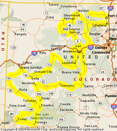
One thing you need to bear in mind is that in October it can get pretty cold at higher elevations, and snow is not out of the question. That said, here’s a route you might consider. The two end points are Loveland and Fort Collins, and you could start at either and end up at the other, doesn’t matter. We’ll start from Fort Collins.

Take CO 14 up the Poudre Canyon over Cameron Pass and down into North Park at Walden.
http://www.motorcyclecolorado.com/poudre_canyon_and_cameron_pass.htm
From Walden, stay on CO 14 down to Muddy Gap and then take US 40 over Rabbit Ears Pass.
http://www.motorcyclecolorado.com/rabbit_ears_pass.htm
This takes you to Steamboat Springs, which you might want to visit but if so you’ll then backtrack a couple miles to get to the next road.

Go south out of Steamboat on CO 131 to Toponas and then take CO 134 over Gore Pass to rejoin US 40 and go south a few miles to Kremmling.
http://www.motorcyclecolorado.com/gore_pass.htm

Go south from Kremmling on CO 9 to Silverthorne and pick up I-70 over Vail Pass and down to Vail. I’m guessing you want to stay a night.

Continue west on I-70 a short distance to the Minturn exit and take Tennessee Pass up to Leadville on US 24.
http://www.motorcyclecolorado.com/tennessee_pass.htm

Continue on to the Twin Lakes turn, at CO 82, and go over Independence Pass to Aspen.
http://www.motorcyclecolorado.com/independence_pass.htm

If you’re planning on staying in Aspen this will be a short day.

Stay on CO 82 to Carbondale and then go south on CO 133 over McClure Pass down to Hotchkiss.
http://www.motorcyclecolorado.com/mcclure_pass.htm

Pick up CO 92 to Delta and then US 50 toward Grand Junction. Before you get to GJ, turn off on CO 141 to Gateway and down to Naturita. This is the Unaweep Canyon scenic byway.
http://www.motorcyclecolorado.com/unaweep_canyon.htm

At Naturita, continue on CO 145 to Placerville and on toward Lizard Head Pass. Along the way you’ll want to run into Telluride and maybe spend the night. Then you’ll return to the road and actually go over Lizard Head Pass.
http://www.motorcyclecolorado.com/lizard_head_pass.htm

Take CO 145 down to Cortez, US 160 over to Durango, and then head back north on US 550 over Red Mountain Pass through Silverton to Ouray and Ridgway and Montrose.
http://www.motorcyclecolorado.com/red_mountain_pass.htm

At Montrose go east on US 50 past the Black Canyon of the Gunnison and Blue Mountain Reservoir to Gunnison and then past there over Monarch Pass and down to Poncha Springs.
http://www.motorcyclecolorado.com/monarch_pass.htm

Pick up US 285 and follow it north to Fairplay, then take CO 9 over Hoosier Pass to Breckenridge and to Frisco where you rejoin I-70.
http://www.motorcyclecolorado.com/hoosier_pass.htm

Go east on I-70 to the Empire exit and US 40 and then take US 40 over Berthoud Pass and down to Winter Park.
http://www.motorcyclecolorado.com/berthoud_pass.htm

Follow US 40 to Granby and then catch US 34, which takes you through Rocky Mountain National Park and over Trail Ridge Road, down to Estes Park.
http://www.motorcyclecolorado.com/trail_ridge_road.htm

Continue on down US 34 through the Big Thompson Canyon to Loveland.
http://www.motorcyclecolorado.com/big_thompson_canyon.htm

That ought to just about do it.

Now, there are some places I left out because I’m not sure how much hard riding you might like to do. Take a look at this and if you want to add more let me know and we’ll work it out. But be aware that mountain riding is slower than crossing the plains, and 250 miles in a day can be plenty. Especially as the days get shorter.

Enjoy.

Recent from National Motorcycle Examiner
Pikes Peak Motomarathon rides southern Colorado

Biker Quote for Today

Get your motor running, head out on the highway
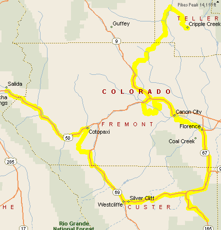
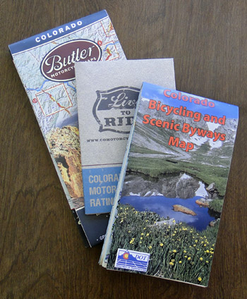
Back Roads and Side Trips You Might Like

Wednesday, August 20th, 2008

We spent a long time going not very far on the second day of the OFMC’s yearly trip this year. As any experienced rider knows, that often implies an especially good ride. It was.

Map of the day's ride

Here’s a map of the route. I’ll have to describe some of it to you since the map doesn’t give enough detail.

We started the trip by getting together in Cripple Creek. Most people reach Cripple Creek by coming down from the north, from U.S. 24 at Divide. Many don’t know there is a back way. We left Cripple Creek via the back way.

To find this road, you take the main drag all the way through town and then hook a right, followed by a quick left. You’re on your way. This is Teller County Road 1. It’s a nice, twisty two-lane that passes through some very pretty country. Go about 7 miles and then turn left on Teller County Road 11. More nice back road. You eventually reach Colorado 9 just a few miles north of where it intersects U.S. 50, a little west of Canon City.

So that’s one back road worthy of a ride. An alternative would be to turn off Teller 11 onto Teller County Road 112, which comes out to Colorado 9 at Guffey. That’s also a nice ride.

We headed on south to U.S. 50 and then turned west. In a short distance we reached Fremont County Road 3, which is the back route up to the Royal Gorge. This very old, very narrow, very twisty little strip of asphalt winds its way up and around to the bridge. You do have to pay to cross the bridge, and if you don’t you have to go back the way you came, but if you’ve never been to the Royal Gorge you really ought to spend the money to do it once. It’s worth it. Plus, we asked for a motorcycle discount and got it. And the road is great.

Once we crossed the bridge we rode back on out the main road and rejoined U.S. 50, and this time we turned east, to Canon City. As you near Canon City you want to keep an eye out for the road over Skyline Drive. This one-lane, one-way, 15-foot wide strip of pavement runs up and along the hogback that overlooks the city. This is a great ride. It’s only 1 mile but it’s a truly spectacular mile.

From Canon City we headed southeast to Florence and then turned south on Colorado 67. This becomes Colorado 96 and turns southwest and then intersects Colorado 165. We made the left turn onto 165 and rode down the 10 miles or so to Bishop Castle. I won’t spend time describing the castle here, just check out the link.

After climbing around in the castle we retraced our route to Colorado 96, headed on west, and reached Colorado 69 at Westcliffe. There we turned north and rejoined U.S. 50 one more time at Cotopaxi. U.S. 50 then carried us up the Arkansas River Valley to Salida, where we stopped for the night. We weren’t more than 50 miles from where we started but what a great day’s ride!

Biker Quote for Today

The twisties – not the superslabs – separate the riders from the squids.