Archive for the ‘Day Rides’ Category

Still Some Riding To Do This Year

Tuesday, November 29th, 2011

starting point for Last Brass Monkey Run

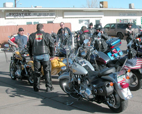
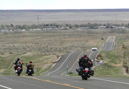
It’s almost December but that doesn’t mean the organized motorcycle rides are over for the year. There are at least three that I know of and I’m definitely not all-knowing.

Two of these are toy runs, to collect gifts for kids who otherwise wouldn’t have much of a Christmas. The other is ABATE’s Last Brass Monkey Run.

This Sunday coming right up is when Rocky Mountain Harley-Davidson will be sponsoring its 26th Annual Toy Run, which collects gifts for kids at Children’s Hospital. The ride starts out in Aurora, at Aurora Sports Park, 18601 Sports Park Drive. Registration is one new, unwrapped toy.

Then, two Sundays later, the Sleigh Riders Motorcycle Toy Run will be held to benefit the Santa Cops program of Weld County. Again, registration is one new, unwrapped toy. The gathering place is in Greeley, at Maui Wowi of Greeley, 2939 65th Ave.

ABATE of Colorado’s Last Brass Monkey Run is scheduled each year to be the last ride of the year. Thanks to the calendar, this year’s run will actually be on Dec. 31, a Saturday. There are two starting points, on the west side and the east side of the metro area, with the destination being the Grizzly Rose, at 58th and I-25. West siders will be gathering at Wrigley’s, in Golden, at 18200 W. Colfax. On the east side, the Pioneer Club is the spot, 18881 E. Colfax. The event offers food, games, a chili cook-off, door prizes, and live music. Riders will start leaving at 10 a.m. and the party gears up at the Grizzly Rose at noon.

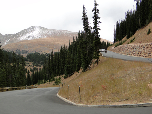
So don’t even think about putting that bike away for the winter. There’s plenty of good riding to be done in the next few months.

Recent from National Motorcycle Examiner
Helmet cams let you relive the ride

Biker Quote for Today

My goal is to see how many gallons of dead dinosaurs I can send through my bike.

Riding Out to See Lions and Tigers and Bears–Oh My!

Thursday, November 17th, 2011

Wild Animal Sanctuary logo

Judy told me on Sunday that she would enjoy going for a motorcycle ride, if that was in my mind, so of course we went. The mountains are not such a desirable destination at this time of year so I thought about where we might go on the plains. Hudson was what I came up with.

Not Hudson itself, really, but a fairly new attraction just outside of town that I had only heard of recently. It’s called the Wild Animal Sanctuary and they provide a home for rescued animals such as lions, bears, bobcats, emus, camels, and a variety of others. Yes, right out there on the prairie, in a climate where you have to wonder how the African lions and camels and such make out.

We checked the website and found that they’re open seven days a week and admission is $10. We geared up, climbed on the Kawi, and took off.

Now, it’s significant how I came to learn that this place existed. I had been following a thread on the Adventure Riders forum that is all about Colorado Front Range Tag-O-Rama. This is a game where you post a picture of your bike in a particular location and it is up to other players to identify the location and ride out, shoot a picture of their bike there, and post that shot. Then they select a new spot, get a shot, post it, and the game continues.

Map to Wild Animal Sanctuary

Well, very early in this game someone posted a tag at the Wild Animal Sanctuary. That’s where I learned about it. And because that is where I had learned about it, I kind of had the idea that the road to it would be paved. Wrong.

We got out there on Sunday and needed to turn south off of CO 52 onto Country Road 53 and 53 was not paved. I turned off onto it anyway but hadn’t gone more than 100 feet when it became clear to me that this just would not do. If we had been on the Honda I might have been game, but the Kawi is so squirrely on gravel that there was just no way this was going to be a good idea. The road was hard-packed underneath but on top there was an inch or two of loose dirt and gravel and I had no confidence at all that I’d be able to keep the rubber down over three miles to get to the sanctuary and then three miles back again. And with Judy on the bike with me there was no way I was going to risk it.

So we turned around, got back on the pavement, and followed a satisfactorily roundabout route back home. We’ll go back sometime in the car. In the meantime, it was still a good ride, and that was really the point all along.

Recent from National Motorcycle Examiner
Latest motorcycle safety study reports released

Biker Quote for Today

I would rather almost die riding in Mexico than almost live working in this stupid office.

Riding On The Plains

Monday, October 31st, 2011

Riding motorcycles on the prairie

It has gotten cool and we’ve had snow in Denver now. I know they’ve gotten a lot more snow in the mountains. I probably won’t be riding up in the hills any more any time soon.

That doesn’t mean I won’t be riding, though. It’s just time to change direction. In fact, I already took my first ride on the prairie this past weekend. Guess what? It’s really nice out there.

In the cooler parts of the year I like to ride around the outskirts of Denver and explore the new construction going on out there. If there’s road that is newly paved, I want to see where it goes. I find myself wandering around out there and sometimes getting lost but how lost can you get on Colorado’s eastern plains? The mountains are to the west.

Of course every time I do this it blows my mind how much construction and new development there is. We have friends who moved from west Denver a few years ago to Watkins and I used to think they were a long way out there. Have you wandered around out there recently? The city is not that far any more. It will probably swallow them in 10 years.

As it is now, houses go on beyond where Smoky Hill Road ends, and of course that road is four lanes almost to the very end. Heck, I remember when it was just two lanes, and I’m not even sure it was paved back when I’m thinking about. But I’ve taken rides out there with some frequency and watched the transformation. For years I looked at these mostly large houses and wondered where in the world all these people got all this money. Of course, now we know many of them never had that money and now I wonder how many of these places are sitting empty. That may buy our friends in Bennett another 5 years before the city gets there.

My point, of course, has nothing to do with houses or the economy. My point is just that even when the mountain roads are snowy there is still a lot of good riding to be done at the lower elevations. I don’t ever put my bikes away for the winter. How about you? Maybe I’ll see you out on the road sometime in January.

Recent from National Motorcycle Examiner
Only a biker knows . . .: Motorcycle wit and wisdom #19

Biker Quote for Today

I wonder where that road goes?

Byways, Byways, We’ve Got Byways

Thursday, October 20th, 2011

Do you ever feel like going for a ride on your motorcycle but can’t figure out where to go, because you’ve already been everywhere, at least locally? I know I get tired of doing the same old routes again and again.

View of South Park from Boreas PassThat’s when it can be good to turn to somebody else’s idea of a good route. And with the modern day convenience of the internet, that can mean Byways.org.

Scenic and historic byways are routes that probably include roads you’ve been on, but perhaps you’ve never combined them in quite the same manner. Take the Lariat Loop. I’ve heard of that route for many years but never really looked into where it goes until today. It starts in Golden, goes up Lookout Mountain and then snakes over to Bergen Park, to Evergreen, and down to Morrison. Then it follows CO 93 back to Golden. I’ve been on all those roads, but have I ever ridden that route all at one time? No.

So Byways.org lists 11 major byways in Colorado, along with 14 others that it says “may be incomplete or contain byways that overlap.” To give you an idea of what’s there, here’s a sampling.

Frontier Pathways Scenic and Historic Byway — Down west of Pueblo, this route runs to Westcliffe, past Bishop Castle, and past the Jackson Hill Stage Stop.

Santa Fe Trail — This ride comes in from Kansas and heads down into New Mexico following–what else?–the old Santa Fe Trail. One nice thing about Byways.org is that it shows you the continuation of roads like this because it covers all the states.

West Elk Loop — Starting and ending at Carbondale, this loop heads up over McClure Pass to Hotchkiss, takes the road through Crawford that runs along the north rim of the Black Canyon of the Gunnison, crosses the dam and heads east into Gunnison, and then turns north to Crested Butte. From Crested Butte, it goes over Kebler Pass back down to CO 133 and back over McClure to Carbondale.

Of course, you don’t need to double back to Carbondale. Heck, you don’t need to do the loop at all. The point is, at least for me, to look at these byways with the idea of identifying roads that perhaps you have overlooked. Or maybe learn about spots along the way that you were unfamiliar with and worth a stop the next time you’re out that way.

Plus, this sort of site strikes me as an excellent resource when you’re planning a trip to an area you are not as familiar with as you are your own home state.

Or you can just continue to ride the same old roads. Totally up to you. Just thought I’d offer an idea.

Recent from National Motorcycle Examiner
Study says 138 million electric two-wheelers by 2017

Biker Quote for Today

Adventure: The pursuit of life.

On the Shelf Road, Finally

Monday, October 17th, 2011

For the first couple years that I was working on this website the focus was entirely on paved roads. I didn’t have any off-road experience, plus there was plenty to keep me busy just putting up info on the paved roads, so I didn’t touch the gravel.

The Shelf RoadThen I got an email from Larry Matkovich, who runs Larry’s Custom Cycle in Canon City, suggesting I add some info on gravel roads (“dirty” roads as he called them) and he offered to provide me the scoop on some, along with a rating system he had devised. Thus was born the Dirt Roads and Side Trips page on the site.

The very first dirt road Larry introduced me to was the Shelf Road, which runs north out of Canon City to Cripple Creek. And although I’ve had it listed on the site for probably three years now, I had never been on it. Until yesterday.

I’m here to tell you, this is a good ride. Using the system he devised, Larry rated this road a 2, “Doable but not recommended for sport bikes, full dressers, some cruisers especially 2-up.” I might be a little more generous, maybe giving it a 1, “Fair gravel road, a bit more skill required, but OK for all bikes.”

Either way, it is a little rough in some places, with a good bit of washboard, but it’s doable. It’s better on a dual-sport, but if you’re on a street bike you can just take your time and ride around the potholes. Kind of like my friend Janet Linn does when she goes over mountain passes on her Ninja.

And boy, yesterday, with the fall colors, it was a beauty, as you can see in the photo. The weather is getting dicier so any of this kind of riding you intend to do you’d better do soon. Yesterday was a good one. It may be the best we’ll see for awhile. Hope you were out riding.

Recent from National Motorcycle Examiner
Hoka Hey finishers did get money

Biker Quote for Today

Go ahead . . . Get married, have kids, drive a van. LOL.

Guanella Pass Really Is Open Again

Monday, October 3rd, 2011

Guanella Pass

I owe thanks on this one to Steve Farson, author of the newly released The Complete Guide to Motorcycling Colorado. I reviewed his book last week and mentioned that he did not tell his readers that Guanella Pass is closed. They closed it in 2008 and the most recent thing I had heard was that there were no plans to reopen it.

Well, what do you know, Steve emailed me to thank me for the positive review AND to tell me that in fact, Guanella was reopened earlier this year. Finally. And he said the road was beautiful, that they have done a terrific job.

Of course Judy and I had to go see for ourselves, and we did on Saturday.

Holy smokes, what a nice road! The asphalt is beautiful, there are a lot of guard rails where there didn’t used to be any, and the new retaining walls are impressive. On top of that, the pavement goes a lot farther than it used to. Used to be, it was paved all the way to the top on the Georgetown side and then just over the crest it turned to gravel. Then it was gravel all the way to Grant, except for some spots where the asphalt from many years ago was still holding together a little.

We checked it on the odometer and here’s what we found. From the top headed toward Grant, the new pavement extends another 3.8 miles. At 8 miles from the top the old surviving pavement starts to get bad and at 9.2 miles it ends altogether. There are then 3.6 miles of gravel before you hit pavement again 0.5 mile from Grant.

So there’s really no reason not to ride this pass. The 3.6 miles of gravel are easily traversable on any street bike as long as you take it nice and easy. Heck, before they closed it for nearly 3 years I used to see Harley baggers and everything else up there, and there was a lot more gravel back then.

Truth is, this road is so much better than it was before I’ve concluded I need to promote it on the website from just a “Dirty Road” mention to its own full page. Look for that sometime next year, as I doubt I’ll have time to get to that right away.

Thanks for the update Steve.

Recent from National Motorcycle Examiner
‘Mythbusters’ reiterates previous ‘bikes not greener’ conclusions

Biker Quote for Today

So many roads, so little time!