Archive for the ‘Day Rides’ Category

Not the Best Fall Ride Ever, But Not Bad

Monday, September 21st, 2009

Judy and I headed up for a fall ride on the Peak-to-Peak highway Saturday, and what a gorgeous day for a ride it was.

We were both really up for this because we haven’t gone for many rides together lately. In fact, it was becoming more and more clear to me that I hadn’t been doing any rides at all for enjoyment lately. I ride plenty, but it’s mostly for transportation. Time to have some fun.

Peak to Peak highway with fall colorsThere were only two problems: traffic and traffic.

We took off up I-25 to catch the 6th Avenue expressway west and out of town, but nearing Broadway the traffic was parked on the interstate. No problem, we’ll just jump off at Broadway and go north and catch 6th that way.

So we got to Alameda and I headed west again, hoping the highway would be clear at that point. We drew near and there was a traffic jam, so we turned north on Delaware, to 1st, to Santa Fe, with intentions of catching 8th west and onto 6th.

Guess again. There was construction on Santa Fe, narrowing traffic to one lane. We crept and crept and finally got past it, got to 8th, and got onto 6th. Only took 45 minutes. :>(

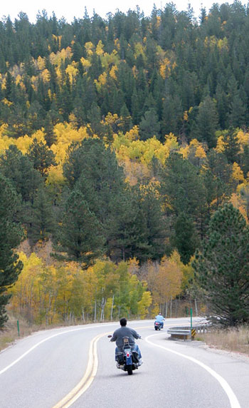
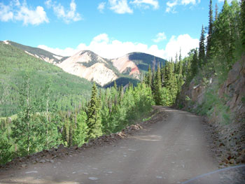
OK, so then it was great. We blew out 6th Avenue, curved around Golden onto CO 93, and then turned west on the road up Golden Gate Canyon. This is what motorcycling in Colorado is all about. Nice curves, towering rocks and cliffs, green forest . . . just sweet.

On up we climbed to where we hit the Peak-to-Peak, CO 119 at this point, and turned north.

It was definitely cooler up on the Peak-to-Peak than it was in town but we were dressed for it. The sun was shining, traffic was light, and there were a lot of motorcycles. Nice day.

We stopped in Nederland to stretch a bit and also to get some ice cream, but in the old part of town where we were we didn’t find it. No problem, Judy suggested we head down to Boulder and get ice cream there.

Boulder Canyon was a sweet ride, too, of course. This whole route is nice, and so close for an afternoon ride. We got to Boulder, headed for the Pearl Street Mall, and found that they have dedicated motorcycle parking right at Pearl Street. Couldn’t ask for better.

We got our ice cream and sat out doing some people watching. Boulder is not like so many other places. People watching here is definitely world class. Lots to see.

Then it was time to head on home and I figured to go down Broadway and take 93 back to Golden, rather than taking the Boulder Turnpike and having to deal with traffic in the center of Denver.

Guess again. We managed to time it perfectly to hit football traffic after the CU Buffs had just beaten Wyoming. All I can say is, working the clutch must really build up the muscles in my left arm. This mess made what we had run into in Denver look not nearly so bad.

Finally we got out of town and even then, 93 was choked with departing football fans. It was stop and go much of the way to Golden. We ended up back home about two hours later than that ride should have taken. A great day up in the mountains but oh man, the city just killed us.

Not to self: Stay away from Boulder on Saturday during the football season.

Recent from National Motorcycle Examiner
Pikes Peak Motomarathon rides southern Colorado

Biker Quote for Today

Helpful Hint: Traffic lights timed for 35mph are also timed for 70, 105, and 140!

Route for Five-Day Colorado Motorcycle Trip

Thursday, September 17th, 2009

I frequently am asked about routes for motorcyclists planning their trips to Colorado, and I’m always glad to offer critiques and suggestions. I figured I’d go ahead and share this recent request with everyone.

Hey Ken, coming to Colorado Oct 2 to do a 5 day ride.. Any suggested routes? Want to go through Vail and Aspen…thanks for your thoughts!

Colorado motorcycle trip map
My response
It appears you’re coming from Michigan, so I’m going to look at this from east to west and back east again. I don’t know if you’ve been here before or this is a first time so I’ll treat it as first time.

One thing you need to bear in mind is that in October it can get pretty cold at higher elevations, and snow is not out of the question. That said, here’s a route you might consider. The two end points are Loveland and Fort Collins, and you could start at either and end up at the other, doesn’t matter. We’ll start from Fort Collins.

Take CO 14 up the Poudre Canyon over Cameron Pass and down into North Park at Walden.
http://www.motorcyclecolorado.com/poudre_canyon_and_cameron_pass.htm
From Walden, stay on CO 14 down to Muddy Gap and then take US 40 over Rabbit Ears Pass.
http://www.motorcyclecolorado.com/rabbit_ears_pass.htm
This takes you to Steamboat Springs, which you might want to visit but if so you’ll then backtrack a couple miles to get to the next road.

Go south out of Steamboat on CO 131 to Toponas and then take CO 134 over Gore Pass to rejoin US 40 and go south a few miles to Kremmling.
http://www.motorcyclecolorado.com/gore_pass.htm

Go south from Kremmling on CO 9 to Silverthorne and pick up I-70 over Vail Pass and down to Vail. I’m guessing you want to stay a night.

Continue west on I-70 a short distance to the Minturn exit and take Tennessee Pass up to Leadville on US 24.
http://www.motorcyclecolorado.com/tennessee_pass.htm

Continue on to the Twin Lakes turn, at CO 82, and go over Independence Pass to Aspen.
http://www.motorcyclecolorado.com/independence_pass.htm

If you’re planning on staying in Aspen this will be a short day.

Stay on CO 82 to Carbondale and then go south on CO 133 over McClure Pass down to Hotchkiss.
http://www.motorcyclecolorado.com/mcclure_pass.htm

Pick up CO 92 to Delta and then US 50 toward Grand Junction. Before you get to GJ, turn off on CO 141 to Gateway and down to Naturita. This is the Unaweep Canyon scenic byway.
http://www.motorcyclecolorado.com/unaweep_canyon.htm

At Naturita, continue on CO 145 to Placerville and on toward Lizard Head Pass. Along the way you’ll want to run into Telluride and maybe spend the night. Then you’ll return to the road and actually go over Lizard Head Pass.
http://www.motorcyclecolorado.com/lizard_head_pass.htm

Take CO 145 down to Cortez, US 160 over to Durango, and then head back north on US 550 over Red Mountain Pass through Silverton to Ouray and Ridgway and Montrose.
http://www.motorcyclecolorado.com/red_mountain_pass.htm

At Montrose go east on US 50 past the Black Canyon of the Gunnison and Blue Mountain Reservoir to Gunnison and then past there over Monarch Pass and down to Poncha Springs.
http://www.motorcyclecolorado.com/monarch_pass.htm

Pick up US 285 and follow it north to Fairplay, then take CO 9 over Hoosier Pass to Breckenridge and to Frisco where you rejoin I-70.
http://www.motorcyclecolorado.com/hoosier_pass.htm

Go east on I-70 to the Empire exit and US 40 and then take US 40 over Berthoud Pass and down to Winter Park.
http://www.motorcyclecolorado.com/berthoud_pass.htm

Follow US 40 to Granby and then catch US 34, which takes you through Rocky Mountain National Park and over Trail Ridge Road, down to Estes Park.
http://www.motorcyclecolorado.com/trail_ridge_road.htm

Continue on down US 34 through the Big Thompson Canyon to Loveland.
http://www.motorcyclecolorado.com/big_thompson_canyon.htm

That ought to just about do it.

Now, there are some places I left out because I’m not sure how much hard riding you might like to do. Take a look at this and if you want to add more let me know and we’ll work it out. But be aware that mountain riding is slower than crossing the plains, and 250 miles in a day can be plenty. Especially as the days get shorter.

Enjoy.

Recent from National Motorcycle Examiner
Pikes Peak Motomarathon rides southern Colorado

Biker Quote for Today

Get your motor running, head out on the highway

Guanella Pass Closed Until Further Notice

Monday, August 24th, 2009

Guanella Pass

September 2, 2009

The National Forest Service has announced that approximately 5 miles of the Guanella Pass Road has been reopened from Georgetown to the Clear Lake day-use area, but the road remains closed between the Clear Lake day-use area and the Clear Lake Campground. After further assessment, the Forest Service and the Clear Creek County Commissioners have decided this part of the road is safe for travel.

Guanella Pass and the Clear Lake Campground can be accessed through Grant, from U.S. 285. Please note that travelers cannot get through to Georgetown or to Interstate 70 from U.S. 285.

August 24, 2009

Be advised that Guanella Pass is closed until further notice. The U.S. Forest Service ordered the closure yesterday because unusually high precipitation this summer has created unstable conditions and provoked fears of a landslide.

Says said John Bustos, spokesman for Arapahoe and Roosevelt National Forests, “With the amount of moisture we have had the rock mass has loosened up and there is concern about it sliding across the road.”

The closure is on the north side of the pass, down from the summit between Georgetown and Clear Lake Campground. That stretch of road is also undergoing extensive reconstruction, so it has been a rough road to ride for quite awhile. The lower portions on both sides of the pass are paved but the stretch of road going over the top is gravel. Although rough, motorcycle of all sorts, including Harley baggers, commonly ride the pass road.

I’ll update this post when the pass reopens.

Recent from National Motorcycle Examiner
Teaching nice people to be dangerous on command

Biker Quote for Today

Remember… It’s not how FAST you get there,… It’s how FAST YOU GO, getting there.

17 Passes in 32 Hours

Monday, July 13th, 2009

Steve Smith had asked my assistance in planning his Colorado ride and he sent me this follow-up now that he’s back home. He rode some passes I’ve never been on. Makes it especially interesting. Here’s Steve’s report.

***************************************************

My trip started in the western North Carolina mountains on Friday, July 3. My dog and I made Oklahoma City that night thru some nice hot weather. Saturday, the 4th, we kept on to New Mexico and up thru Taos to Antonito, Colorado area. I was not sure just exactly where some of the campgrounds were located on your website, so I took the safe route and checked AAA where I found the camp ground at Mogote. The people were nice and had a free cook out that evening. The facilities were nice with a shower and nice shaded camping area for $18.

sport bikes
  Stunner Pass

The next morning I rode past the camp grounds that you mentioned and they looked very nice. My goal was to ride to the pass and find a sign and get a picture, so my first pass that morning was La Manga. It was a nice ride over to Cumbres for my second pass in just 30 minutes or so. I retraced my tracks back across La Manga to the forest road 250 and up to Stunner Pass. This road was very navigable but not recommended for a shiny Harley or Goldwing, due to the rocks and potholes. I was riding a loaded 1150 GS and it was slow going in a few places. As with all the roads in Colorado, they are all very scenic with great vistas. I kept going north up to the highway and made a left turn to Wolf Creek Pass for my 4th pass that day.

The next two passes were easy to achieve on a great road up thru Creede and on to Spring Creek Pass and then Slumgullion Pass for the 5th and 6th passes. Just past Slumgullion towards Lake City I made a right turn towards Los Pinos Pass. This road was even rougher than the road to Stunner but still was very scenic. At this pass the sign had disappeared so I have no picture of that one.

Once thru the pass it was about 29 miles out to Hwy 114 and to North Pass for my 8th pass. A u-turn took me back to Gunnison where I went up thru Crested Butte and on towards Kebler Pass. Before I got to that one there was a road off to the left to Ohio Pass. I found no sign but a nice rocky, pot-holed road for a couple of miles. Kebler was my 10th pass that day and the road on out to Paonia was a very nice gravel road. The aspen surrounding the Lupines and was a sight to behold. That evening I camped at the Redstone campground for $32. Yes I went over McClure Pass but since it was under 10,000 ft, I didn’t count it for that day.

By the end of the day I had ridden over 10 passes above 10,000 feet and was done with the pass counting in 10 hours.

sport bikes
  Los Pinos Road

The next morning, I left Redstone and ventured up thru the slow traffic at Aspen to Independence Pass. Wow, the views were great. My next pass was Tennessee Pass north of Leadville. I retraced my track back to Leadville for lunch and then up to Fremont Pass. I continued north to I-70 over Vail Pass and then on to Shrine Pass, just a short 3 miles from the rest area on a good hard packed road that any bike could handle.

Next in my sights was Loveland Pass and then to Guanella Pass south of Georgetown, but the road was closed for construction so I went to Berthoud Pass instead. That was my last pass, as I told my sister I would be at her house north of Woodland Park at 4 PM. The road down thru Deckers was very nice and I was able to beat or avoid some rain and hail.

My total account was 17 passes over 10,000 ft. I started around 8 AM on July 5th and was drinking a cool one by 4 PM the next afternoon or 32 hours total. In hindsight I could have done more if I wasn’t so packed down and left my dog at home, but we had an excellent ride thru some very beautiful country.

I would not recommend Stunner and Los Pinos Passes for an inexperienced rider. That may be done better in a car or truck. On the other hand, any bike could make it, but it may be missing some parts that get rattled off during the ride.

***************************************************

OK, so thank you Steve for that ride description. Now I’m going to have to find out where Stunner and Los Pinos Passes are.

Recent from the National Motorcycle Examiner
Could there be an Eco Mobile in your future?

Biker Quote for Today

If it can’t do some dirt, why bother?

Texas Rides The Rockies

Monday, June 29th, 2009

Texas rides the Rockies map

I’m frequently asked to help people plan their routes when they’re coming to Colorado to ride, and I’m always happy to oblige.

Last year I posted a series I called “New Zealand Rides The Rockies” where I laid out the day by day rides of a group on New Zealanders planning to come here this year. Unfortunately, the world economic meltdown derailed their plans, at least for now.

However, if you don’t have to fly halfway around the world and you don’t have to rent motorcycles, coming to Colorado to ride is actually one of the less expensive vacations you can take. I can confirm that a good number of people are doing just that.

Among them are Ray and some of his friends from Texas, who are cruising around Colorado right this moment, presuming they didn’t have any last minute glitches. I’m not going to lay this out in the detail I did for the Kiwis but I figured you might have some interest in their plans.

Days One and Two

Ray and friends are coming from the Dallas-Ft. Worth area (I believe) and were riding to Las Vegas, NM, the first night. From there, on Day Two, they were planning to head north to Taos and on up to where they would reach U.S. 160 at Fort Garland. They planned on taking U.S. 160 west to South Fork, then CO 149 over Slumgullion Pass to Lake City, and then the gravel roads over to just south of Ouray. Ridgway was their destination for the night.

These plans were revised considerably when I pointed out to Ray that it would be a much nicer ride to take U.S. 64 west from just north of Taos, via Chama, and then U.S. 84 up to Pagosa Springs. From Pagosa, a run over Wolf Creek Pass would put them at South Fork. I also mentioned that they must be riding dual sport bikes if they were planning on taking that road west out of Lake City.

Apparently they aren’t, so that road was nixed. Instead, they adopted my suggestion of the Chama route and then just continued on through Lake City to Gunnison for the night.

Day Three

Day Three was to be a fairly easy one after a long Day Two. Heading west out of Gunnison they planned to stop at Black Canyon of the Gunnison National Park and ride the South Rim Drive and the East Portal Road. Then they would make the easy cruise to Ouray and make that their headquarters for two nights.

Day Four

Day Four is planned as a circle route through Ridgway, Placerville, Telluride, Cortez, Durango, Silverton, and back to Ouray. This will take them over Lizard Head Pass and Red Mountain Pass. Red Mountain Pass, of course, is one of the best in the state.

Day Five

On Day Five, Ray and friends are heading north through Montrose and Delta and will then head northeast on CO 92 to Hotchkiss and up and over McClure Pass on CO 133. At Carbondale they will turn southeast on CO 82 through Aspen and over Independence Pass, another of Colorado’s very best.

A run through Leadville and then down Fremont Pass to Copper Mountain will put them at I-70, where they will head east to Silverthorne. They’ll take U.S. 6 up over Loveland Pass and end up for the night in Idaho Springs.

Day Six

From Idaho Springs our travelers will head south on CO 103 up Squaw Pass with a sidetrip to the top of Mount Evans. From the Bergen Park area they’ll head south to Evergreen and on to Conifer where they’ll pick up U.S. 285 for just a short jaunt. At Pine Junction they’ll head south on CO 126 through Deckers and on to Woodland Park and Colorado Springs.

Days Seven and Eight

In the morning of Day Seven, Ray and the rest will make a run up to the top of Pikes Peak, then head back down and blast homeward as far as Amarillo. Day Eight will see them home again in the Dallas area.

Recent from National Motorcycle Examiner
10th Annual V2V: Victory riders ride Victory Highway

Biker Quote for Today

Fun is not a straight line.

New Motorcycle Examiner Takes on Colorado

Thursday, June 25th, 2009

Dom Chang, also known as Redleg, is off and running hard as the newest motorcycle Examiner in Colorado. Some of you may already know Dom/Redleg as the blogger of Redleg’s Rides, which is where I met him.

Colorado Motorcycle Travel ExaminerAs you may know, for one year I was the Denver Motorcycle Examiner, and have now become Examiner.com‘s National Motorcycle Examiner. That created a vacancy at the local level so I contacted Dom to ask if he would be interested in the spot. “Heck yes I would,” was his reply.

The folks at Examiner have their own approach to these things, however, which are not always clear to me, so Dom actually ended up as the Colorado Motorcycle Travel Examiner.

Whatever. Doesn’t matter to me, and I presume it doesn’t matter to Dom. The point is, he’s burst out of the starting gate like a rocket and is putting up a lot of great information about places to ride in Colorado. And Dom is no weekend biker; he rides all the time. Here’s his Examiner bio:

A late blooming motorcycle rider, Dom explores motorcycle-accessible Colorado year round. Averaging 20 thousand plus miles a year on his beemers, he’s a ride-reporting, farkle reviewing, basic motorcycle servicing, solo touring rider and blogger.

He also had this to say in his first Examiner post:

I’ve been motorcycling since the Spring of 2006 and have accumulated over 50,000 motorcycling miles since then. I commute to work on my motorcycles unless there’s ice or snow on the road. I’ve traveled the length and breath of Colorado in search of motorcycling destinations and byways, this information and experience I hope to relate to you in future articles.

Did I mention that Dom is a terrific photographer? Dom shoots pictures wherever he goes and frequently stitches multiple images together to give you great panoramic views. Unfortunately, Examiner does not accommodate his photography the way his blog does, but when he presents one of these panoramas on Examiner he links to the shot on his blog so you can really appreciate it.

So check him out. Blog and/or Examiner, Dom’s sites are good adds to your Favorites list.

Recent from the National Motorcycle Examiner
One more sweet motorcycle road in southern Utah

Biker Quote for Today

Ride, Eat, Sleep, Repeat, Repeat, Repeat………..