Archive for the ‘Colorado motorcycle rides’ Category

Stove Prairie Road a Good Ride, But Don’t Go Down

Monday, October 27th, 2008

An interesting news report about the Fort Collins Chief of Police. He was up on Stove Prairie Road and went down on his buddy’s Road King. He suffered a broken pelvis but got back on the bike and rode into town to the hospital.

“It was very apparent something was really wrong,” said Chief Dennis Harrison.

Yeah, I guess. Call me a wuss but I think I would have waited for the ambulance. Oh, and no mention about the condition of the bike.

Stove Prairie Road
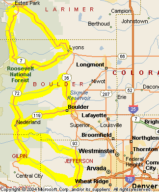
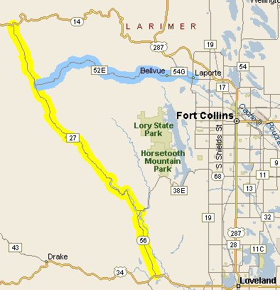
No place is a good place to go down but Chief Harrison did pick a nice place to ride. I’ve been on that road many times and I strongly recommend it. What it is best is a way to avoid going through all the sprawl of Fort Collins when you’re on your way up the Poudre Canyon. The Stove Prairie Road runs over the ridge from the Buckhorn Canyon to the Poudre. Here’s a map showing the area.

What you do is head west out of Loveland on US 34, like you’re going up to Estes Park, except just a bit west of town, as you get past the hogback, you go north on CO 56 to Masonville. At Masonville you go left at the T intersection. Right takes you down by Horsetooth Reservoir and into Fort Collins. Left takes you up the Buckhorn.

You don’t need to worry about finding the Stove Prairie turnoff because that’s the way the pavement goes. Where the Buckhorn road and the Stove Prairie road diverge the Buckhorn road turns to gravel. So stay on the pavement.

The road rises up to the tiny community of Stove Prairie and then heads down into the Poudre. A left takes you up the Poudre on CO 14, over Cameron Pass, and down into North Park. A right takes you very quickly to the Mishiwaka Inn, the best bar in these parts, and then down to hit US 287 just a couple miles outside of LaPorte.

There’s one other good riding option you might want to be aware of, and that is the Rist Canyon road. From up on top, at Stove Prairie, the Rist Canyon road (Larimer County Road 52E) takes you directly down into LaPorte. Once you come over the crest it is a very steep downward run that is reminiscent of coming into Golden on the Lookout Mountain road.

It’s all good riding. But you’ll enjoy it more if you keep the rubber side down.

Biker Quote for Today

Never ride faster than your guardian angel can fly.

Mount Evans Road First to Close for Season

Friday, October 10th, 2008

It’s getting to be that time of year. The road to the top of Mount Evans has closed, so that means other roads can’t be far behind.

Others that close for the winter include:

You can keep tabs on which of these are still open, as well as get real-time info on road conditions around the state at the Colorado Department of Transportation site.

The other roads are maintained all year round but you never know when they’ll be getting snow. The truth of the matter is, although I ride down here on the flatland all year round, I almost never ride in the mountains after October. There are more hardy riders than me, though. Redleg comes to mind. He seems to ride anywhere he wants any time he wants. You’re a better man than me, buddy.

Biker Quote for Today

Winter is nature’s way of telling you to polish your bike.

Update on Guanella Pass

Monday, August 25th, 2008

I wrote just three days ago about the conditions on Guanella Pass, so with that on my mind, when my wife wanted to head for the high country the next day I knew where I wanted to go.

The last time we were up there was two years ago, and what we saw then was what I described. Well, there is a lot that has changed in two years.

For one thing, the reconstruction work I mentioned has begun, and going up from the Georgetown side the road is horrible. Horrible! It’s one lane in several places, with traffic signals stopping you or letting you pass, but the road surface on most of it is so bad it’s amazing. I can hardly believe the county would let it get this bad, although I wonder if perhaps it is the heavy construction going on that has torn the road up like this. If that’s the case then of course they won’t want to repair the road surface until the heavy work is done. The project won’t be completed for another couple years.

After awhile you get past the mess and then the road is pretty good the rest of the way up. It’s mostly paved, although still rough, and just as you near the top it turns to gravel. It’s definitely passable. We couldn’t really tell what the condition was two years ago because it was all covered with snow at that time.

And it is beautiful up on top! It was beautiful last time, too, but it was an all-covered-with-snow beauty. I had forgotten just how spectacular it is when the snow is gone.

Heading on down the other side it continues as gravel and gets to be a lot of washboard. Then abruptly, about a mile from the top, you hit nice new asphalt. We guessed that this was where we hit the county line. If you look at the picture I included in the last post and you see the poor surface, that’s all been redone. The new asphalt continues for several miles and then you get back to the older surface and intermittent gravel. It’s all very passable, although if it has rained you will face mud.

So bottom line on all this, I still wouldn’t take a Gold Wing on this road but anyone who doesn’t mind doing some dirt would find this a really nice ride. You’ll need to go slow on the part where the surface is so bad but you definitely can do it. Just try not to get caught in a thundershower.

Consequently, I will be adding this road to the Dirt Roads and Side Trips page of the website.

Biker Quote for Today

Patience is the ability to keep your motor idling.

Guanella Pass Is Good for the Adventurous

Friday, August 22nd, 2008

Guanella Pass
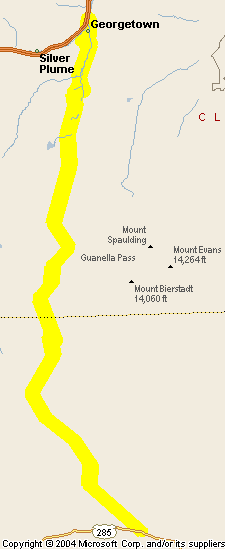
One really nice ride that I don’t have on the website is Guanella Pass, which runs from Georgetown on the north down to U.S. 285 at Grant, west of Bailey, on the south. Here’s a map but the mapping software doesn’t bring in smaller roads unless I zoom in more, and then it won’t all fit on the screen. I don’t have this pass on the site because a significant portion of it is unpaved, particularly up at the top where the going can be quite rough.

Still, if you’ve got the right kind of bike and an adventurous spirit, this is a really nice pass and there’s not a lot of traffic. Plus, it’s close in to Denver so it makes an easy day ride. I would strongly recommend you not try this on your Gold Wing, however.

If you do decide you want to take this ride I would also strongly recommend that you do it in the middle of summer. The last time we went over it, two years ago in late April in a car, there was still snow at the top and even in the car it was treacherous. Not to mention muddy as we got down below the level of the snow.

There has been talk over the years of paving Guanella Pass completely, but it doesn’t look like that is going to happen. It is already paved for a good bit, although the asphalt is old and in bad shape. That may be changing, however. The most recent push for paving the entire road was fought out between those for and those against, with those against saying it would ruin the beauty and charm of the route. I don’t think there is any doubt it would have a significant effect, because I’m sure it would bring a lot more traffic up there.

Guanella Pass
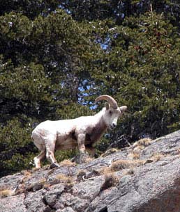
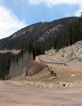
The dispute was settled with a decision to improve the road, partially to prevent erosion, but not to pave or widen the whole thing. I’m guessing that means the old, broken-down asphalt will be repaved, some areas particularly prone to erosion may be paved for the first time, and other lesser enhancements made. This photo gives you a bit of an idea about the condition of the asphalt, at least back in April 2006.

If you’re not inclined to take this road on your bike you might want to consider going in your car. It really is beautiful, there are some very nice campgrounds up there, and there is a lot of wildlife. We saw mountain goats and big-horn sheep as well as other animals. Here’s a shot of one of the guys we saw. He was being pretty protective of the females in his group.

Wildlife on Guanella Pass

Biker Quote for Today

There is no such thing as a bad day when riding a dirtbike.

Some High Roads Open, Some Still Closed

Monday, June 9th, 2008

We’ve had a phenomenal winter for snowfall in the mountains and that has an impact on some of the best motorcycle roads in the state.

The good news is that Independence Pass, CO 82 between Twin Lakes and Aspen is finally open. From what I’ve heard, though, it is still subject to periodic closures depending on conditions. I’d check first before heading that way.

CO 5 to the top of Mount Evans is also open, as is the Pike’s Peak Highway, which goes to the top of that 14,110-foot mountain.

Trail Ridge Road, on the other hand, is still closed. The Colorado Department of Transportation says the closure is “between Milner Pass and Rainbow Curve due to adverse conditions.” They don’t say when it will be open.

A couple other passes that are still closed are only of interest if you’re the sort who doesn’t mind doing some dirt.

Kebler Pass, coming down from Crested Butte toward Paonia is still closed. You can get to Crested Butte on CO 135, which is paved, but the stretch over Kebler, County Road 12, is dirt.

Likewise, Cottonwood Pass is still closed. Again, you can get up the east side of Cottonwood from Buena Vista on a paved road. Just don’t think you’re going to get down the other side, whether you ride dirt or not.

We love the snowfall. The skiers had a good winter. Our reservoirs will be full this summer. But you’re going to have to be patient before you can ride some of these roads.

Biker Quote for Today

Ride often, ride well, have fun.

New Zealand Rides The Rockies – Day 10

Friday, March 14th, 2008

Recap: Steve and some buddies are coming from New Zealand in 2009 for some motorcycle touring in Colorado and Utah. This series of posts lays out their proposed routes, with my comments. Your comments are welcome as well.

Day 10

Oh no! This 10-day motorcycle ride around the Rockies is coming to an end. Today is the final day. Dang. Oh well, Steve and the gang are in Golden and need to end up back in pretty much the same place in order to turn in the bikes and head home. Today they’re going to cruise the Peak-to-Peak Highway and check out the canyons leading up and down between this road and the flatlands. They don’t have a detailed route in mind so this can be taken as a possible route. Here’s the map, and the enlarged view.

Peak-to-Peak Highway and adjoining canyons

At day’s end yesterday, our group came down US 6 through Clear Creek Canyon, so we don’t really need to backtrack today. Going north out of Golden on CO 93 it is just a couple miles to the turn-off to CO 46 up Golden Gate Canyon. This is a favorite ride and a great way to start the day. Winding up the canyon, you reach CO 119, which is the southern portion of the Peak-to-Peak. From here we’ll turn north, to the right.

Now, there are any number of ways you could do this ride. I’m going to suggest that they just go all the way to Estes Park in the beginning and then work the canyons on the way back. That means CO 119 as far as Nederland, then CO 72 to where it terminates into CO 7, and then CO 7 to Estes Park. Don’t be surprised coming into Estes Park if you come upon a traffic back-up, there are herds of elk around here that are not shy and everyone stops to look.

From Estes Park we now turn east on US 36. This road goes down the North St. Vrain toward Lyons. At Lyons you just cruise through town and out the other side and you’re back on CO 7, which goes back up the South St. Vrain to where you met it before. At that point it’s time to head south on CO 72, the road you came north on.

Heading south on CO 72 you come (again) to Ward, and the intersection with Lefthand Canyon Drive, or Boulder County Road 94. Go ahead and take this turn. It runs down (surprise!) Lefthand Canyon and comes out to US 36 north of Boulder. Head south toward Boulder but when US 36 jogs to the left, stay straight on CO 7, Broadway. This will be a nicer ride through town.

Broadway leads you right into the middle of Boulder, where you take a right on either Walnut or Canyon and on out of town directly into Boulder Canyon on CO 119. There are a number of places to stop on your way up this canyon, and one of the best is Boulder Falls.

CO 119 reconnects you with the Peak-to-Peak at Nederland. Nederland, by the way, is where the Caribou recording studios were located, where a lot of great music was recorded in the 1970s.

At Nederland we stay on CO 119, which heads south, but very soon turn off onto CO 72, which goes down Coal Creek Canyon. Of course, before it goes down too far it first has to go up and over the crest at Wondervu. Nice switchbacks along here and Wondervu is a good place to stop for a break. Coal Creek Canyon comes out CO 93 at the former Rocky Flats Nuclear Weapons Plant. This plant used to build the plutonium triggers for nuclear weapons, but has been decommissioned and is now undergoing environmental clean-up.

We head south on CO 93 and another short jaunt brings us back to Golden and the end of the last day of this terrific trip. Now — darn! — they’re going to be stuck riding the terrific roads in New Zealand again. Until the next time! See you then.