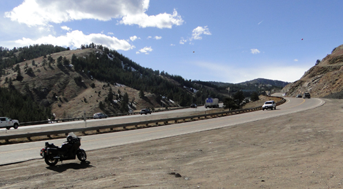
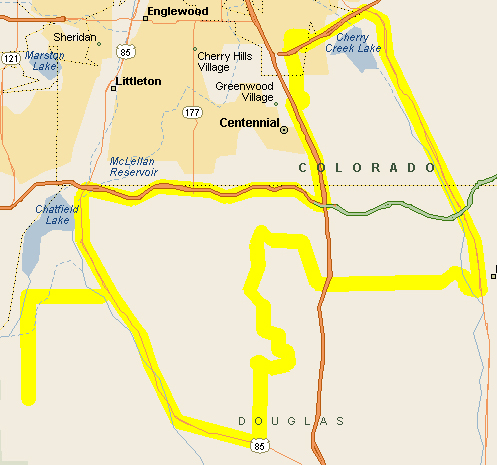
Archive for the ‘Colorado motorcycle rides’ Category

A New Route Up The Mountain

Thursday, March 15th, 2018
two highways side by side

That’s not just a frontage road along I-70, that’s U.S. Highway 40.

What, did some huge rainstorm carve out a new canyon? How is it possible that I could have gone up into the hills right here in the metro area on a new road?

This one has been hiding in plain sight: Mount Vernon Canyon.

If you’re like most people you just said, “What?”

Mount Vernon Canyon is the canyon everyone has been up and down through but never heard of. You know I-70? That’s Mount Vernon Canyon. But did you know that U.S. 40 also goes up through that same canyon?

All the way up to Genesee U.S. 40 runs pretty much right alongside I-70. Heading up the hill you won’t even see U.S. 40 because it is above you; coming down it is more visible. And while I recently came down part of that road for the first time, I had never gone up it. Until Saturday.

Where do you even get on this road? If you’re coming north on CO 93 out of Morrison you take the left on the north side of I-70; coming south from Golden you’re already on U.S. 40 and you follow the sign going to the right, west. (Don’t get confused; not the on-ramp to I-70.)

It’s a pleasant ride, with not a lot of traffic. Once you get to Genesee U.S. 40 merges with I-70 just for a short distance and you can then get back off the superslab at the exit for Evergreen Parkway. Cross to the south side of the interstate and then take the first right turn. This puts you back on U.S. 40 and you’ll cross back to the north side of the interstate and then for awhile you’ll get completely away from the big road.

The two roads do draw close together again after a bit, especially as you come up to Floyd Hill, and then U.S. 40 winds down Floyd Hill to meet U.S. 6 coming up through Clear Creek Canyon. U.S. 40 continues west from there but it is incorporated into I-70 so that’s the end of this nice alternative stretch of road.

Biker Quote for Today

Why bikes are better than women: Motorcycles don’t care if you are late.

Motorcycle Link for Today

When you need motorcycle tires, Toyo Tires are a good option.

You’re Not Welcome Here

Monday, March 12th, 2018
map of my route

My route.

I took off on the CB750 not knowing where I was headed so I wandered over onto Parker Road. That at least would get me out of town.

I knew from a couple rides that there is a road that runs diagonally between Parker and Castle Rock and I had only ever taken that road coming to Parker, never going to Castle Rock. In fact, I wasn’t even sure (memory not clear) where it came out in Parker. So let’s go find it and take it the other direction.

I got into the old downtown area of Parker and eyeballed Main Street heading west wondering if that was where that road came in. I didn’t think so and I kept on. I had the idea in mind that I wanted Hess Road but wasn’t sure.

Next I came to Twenty Mile Road and that looked promising so I turned. At the very least, this was exploring. After going west a short distance, Twenty Mile Road turned north and soon intersected with Main Street. OK, turn left. I guess I’ll see where Main Street goes.

I knew that Parker had grown enormously over the years but I always had it in mind that it had grown mostly to the east. Wrong. There is a huge part of the city to the west, and I went right through it. This was clearly not the road to Castle Rock. In fact, as I got further along I could see the Reuter-Hess Reservoir further south, confirming that I had really wanted Hess Road. But I had never been west out of Parker on Main Street so again, this was exploring.

Where did this road come out? Well, first of all, it came out of the city into open fields and no development at all. (This road is so new that my mapping software, a few years out of date, does not even show it.) You know as well as I do that that won’t be the case for long. But it went on and hit I-25 at the I-25 exit for the Cabela’s store on the south end of the metro area. Now I knew. And by this time it was Ridge Gate Parkway.

After crossing I-25 Ridge Gate Parkway bent north and soon it intersected Lincoln Avenue. I went west on Lincoln Avenue, now figuring I wanted to work my way over to Chatfield Reservoir. I’d been over there a couple times recently and had seen this road, Rampart Range Road, that went off somewhere that had me curious.

I turned south off Lincoln Avenue onto South Quebec Street and that wound its way further and further south, becoming Monarch Boulevard along the way. I had been this way recently. When Monarch Parkway hit Castle Pines Parkway I knew exactly where I was. I turned west on Castle Pines Parkway to Daniels Park Road and took that south to U.S. 85. Then north, past Sedalia, and off at Titan Parkway, which leads over to the road going around the south of Chatfield.

Titan Parkway runs straight west almost to Chatfield State Park and then a 90-degree turn puts you on Rampart Range Road. A little ways south you hit Waterton Road and this is the road around the south end of the park and reservoir. But where do you go if you continue south? This was what I had come to find out.

Of course, this area is where you find Roxborough State Park, an area of gorgeous rock formations. Continuing south on Rampart Range Road I saw for the first time some neighborhoods built in really beautiful settings among these rocks. Oh my gosh! I bet these places are expensive.

Then the road went up a bit of an incline and curved in between two miniature flatirons and I was starting to think that, oh boy, this is really going to be cool. But I came between the rocks and there was a sign, “Residents only right lane,” and a guard shack. I stopped at the guard shack and a very nice older woman, in the role of guard, greeted me.

“Howdy. I’m exploring,” I said. “I was wondering where this road goes.”

“This is the Arrowhead gated community,” she replied.

“So does this road come out somewhere else?” I asked.

“No, it’s one way in, one way out.”

“OK, I guess that’s all I need to know,” I replied, knowing that meant I was now supposed to turn around. And she pointed me to the turnaround, just in case I wasn’t totally clear on the matter.

Now I know.

Biker Quote for Today

Every mile is my destination. Every failure is my motivation. I’m a rider. I live to ride. Nothing comes between me and my bike. I’m a rider and I’ll survive. — Sagar ZZ

Getting In Some February Rides

Thursday, February 8th, 2018
Rokon wheel in snow

Some people ride even in this kind of conditions. You’ve got no excuse at all not to be riding in this warm weather we’ve been having.

I was out riding Wednesday on that warm February afternoon. Is Colorado a great place to live or what?

As always at this time of the year, I was being opportunistic. It was warm; I rode. I make a point to ride each of my bikes at least once every calendar month and I can check February off the list.

But even if I didn’t have that incentive I would have been out. It’s just too nice not to. It has been quite cold in the morning but by 11 o’clock it has been in the 50s and that’s good riding weather. And there’s no snow or ice on the ground, unlike in that photo above. (I shot that photo at the Elephant Ride a few years ago. Yeah, there was plenty of snow then.)

Riding the fully faired Concours and then the unfaired CB750, back to back, it was pretty dang obvious how much benefit that fairing offers. I was perfectly warm on the Connie but definitely felt a chill on the CB. But I turned on my electric vest and all was just fine. Didn’t even need the electric gloves.

Now, I would hope that this is not the last of my February riding. I see nothing in the forecast that suggests we’ll be snowed in the rest of the month, but you never know. Assuming that doesn’t happen I should be out a bunch more times. I’m really counting on getting a lot of miles under me this year. And I’m not waiting till May to get started.

Biker Quote for Today

Whether rain or sunshine, heat or cold, my bike and I are on the road.

Finding Riding Trails In Colorado

Thursday, January 25th, 2018
www.trailtaker.com

The TrailTaker site could be a good tool to spark riding ideas.

I owe Mark Odette on this one. He sent me an email way back in September and I forgot about it, but was digging through old emails today and ran across it.

For those of us who like to get off the paved roads (I include myself generously; since getting my V-Strom I haven’t been off the pavement nearly as much as I wish I had), one topic of interest is where to go to do so. Sure, there are gravel roads all over, but which of them are worth riding, and pack the best bang for your time buck?

Maybe you should check out www.trailtaker.com. Click on that link and go to their trails map and then click on one of the markers. That enlarges the map to show an area of the state and if you give it some time the map starts filling in with all kinds of trails.

For instance, I clicked on an area that runs from Lake George on the east to Aspen on the west and Alma on the north to Salida on the south. There are more trails than I can count, colored red, green, and blue. Red is advanced, blue is intermediate, and green is beginner. The legend also shows grey as unknown and black as expert but I don’t see any of those here.

And what are these trails? Well, I clicked on one that runs off US 285 toward the Collegiate Peaks. I’ve been down that road many times and looked at a road going off into the hills and wondered about it. I’m thinking this is that road. The site tells me this is Clear Creek and that it’s 9.18 miles long. It’s blue. Clicking on the “Trail Details” link it doesn’t actually give me that much more information, other than that it’s a gravel road suitable for a passenger car. And there is a link to download a GPS file (.GPX) of the trail. It also notes that the information is not verified because it has been imported from public date provided by the U.S. Forest Service. Many of these trails are like this.

Over to the east of Fairplay, near Tarryall Reservoir, there is the Packer Gulch trail (7.8 miles). Here the blue of the trail actually refers to being intermediate for 4×4 vehicles. For motorcycles it is rated unknown. It calls for high-clearance vehicles and the road is not maintained for passenger cars.

Let’s get to something a bit gnarlier. A little west of Buena Vista, with a southern terminus near Tincup, is the Timberline trail (30.3 miles). This is rated advanced for both motorcycles and ATVs and 4x4s are not permitted. This is listed as Trail Class TC4, Highly Developed. This appears to be a Forest Service designation meaning “high standard trail with significant structures, tread hardening possible.”

So you get the idea. Is that just a gravel road going off to nowhere or is it actually a trail? This site might be just the answer.

Biker Quote for Today

Why bikes are better than women: If your Motorcycle is misaligned, you don’t have to discuss politics to correct it.

Stick These In Your Pocket

Monday, January 22nd, 2018

Do thermometers lie? I was out riding on Saturday, a sunny 48 degrees and my fingers were turning into ice cubes. And I was wearing my non-electric winter gloves, with Thinsulate© lining. How could I be so cold on such a warm day?

I understand that the 60 degrees showing on our thermometer out front is not to be trusted because it is sheltered and has a southern exposure. But I trusted the 48 degrees the thermometer out back, in the shade, told me. Of course I wore my electric vest–I never ride without that at this time of year.

chemical hand warmers

Put some of these in your jacket pocket.

So I took off on the V-Strom and hadn’t gone three blocks when I realized I would have been happy to have had long underwear on. Sure I could have gone back but what the heck, I can live with it. So I won’t whine about my legs being cold, although they definitely were.

But then by the time I was gone about five miles my hands were really getting cold. And it was a sunny day! I don’t get it. This is Colorado.

Oh well, I was going for a ride. So I did.

I headed down Jordan Road to Arapahoe Road and turned east. I crossed Parker Road and decided to follow Arapahoe further and see where it went. I knew I’d been out that way before but just at the moment I couldn’t remember. And it did go on straight pretty far, until just before reaching C-470 it started wiggling. Then I remembered, it twists around and then heads north and intersects Smoky Hill Road.

Yep, that’s what it did, but then, where does it go beyond Smoky Hill? I guess I’ll have to find out.

Well, the answer is not very far. It winds around through a shopping area briefly and then dissolves into a housing development, becoming nothing more than a small collector street. And then it just ended where new development is still going on and there are more empty lots than new homes.

I turned south on Titus Way, which quickly brought me back to Smoky Hill. OK, my hands are cold enough, I’m turning right and heading home. It wasn’t as long a ride as I might have liked but at least I did get out. Friday would have been better–it was warmer–but we were just coming home from Grand Junction and I missed the better, warmer part of that day. So I rode on Saturday.

I had a realization though. There I was with freezing hands and while, sure, I could have worn my heated gloves but I didn’t, still, there is really no good reason why I didn’t have some of those chemical heat packs stuffed in my jacket pocket for just this sort of occasion. I have some, and once you buy those things there is no reason not to use them because if you keep them too long they lose potency. Why weren’t they in my pocket?

They are now.

Biker Quote for Today

Missing: Husband and motorcycle. Reward for motorcycle.

Exploring! I Love It!

Thursday, December 7th, 2017
map of my route

My route

With this terrific December weather–and portents of cold to come–I’ve been getting in a lot of riding. And lately that has meant exploring. I love exploring. Generally I just follow my nose and go.

On Saturday I headed out on the Honda with kind of an idea that I might ride up Deer Creek Canyon, cut over by Tiny Town, and then come on back down on US 285. But my plans got thrown off.

First I headed west on Belleview but I had forgotten that a little west of Federal you run into Bow Mar and can’t continue. I jogged north to Quincy and continued west as far as Wadsworth and then turned south on Wadsworth. That got me to thinking, “Where does Wadsworth go, way far south?” I kind of had the idea it came out at C-470 near Chatfield Reservoir but couldn’t remember it all exactly. So I went south.

Sure enough, I crossed under C-470 and there was Chatfield on my left and I was running on south along its western boundary. My (perhaps incorrect) recollection was that this road ran down to Martin-Marietta and to Waterton Canyon, where you had no choice but to go up the canyon, and I was pretty sure that was closed to vehicles. Which is to say, that the road ended. We’ll see. Can you go all the way around Chatfield?

There’s a point where the road bends to the right if you’re going to Martin or you can turn left onto Waterton Road. It looked like it might go through. Sure enough, it goes around the south end of the reservoir/park and hits a T-intersection with Rampart Range Road. Really? I’ve only ever gotten to the Rampart Range via Sedalia. I’m going to have to check this out someday, but for now I was interested in getting around Chatfield Reservoir so I turned left.

Rampart Range Road goes north until it bends right, now heading east. This was now Titan Road, which hits South Santa Fe/US 85 at that fairly new interchange (marked “Titan Road” oddly enough!). So I’d done it. I never knew you could go around Chatfield ever before.

Heading north then on US 85 I was going to just hit C-470 but I came up on Highlands Ranch Parkway and decided to explore some more. I had been on this particular road before but only parts of it. I had no idea where it came out on the other end. Time to find out.

This parkway winds its way through this whole, large development, now passing houses, now passing through massive, sprawling shopping districts with their all-enveloping smell of fried chicken. I passed Lucent Boulevard, then Broadway, then University Boulevard. Where the heck does this thing go?

Well, right after University I found out. It bent sharply north and I suspected I was on a different street. I looked at the first sign I could see and–holy smokes!–I was now on Colorado Boulevard. Really?

OK, so the rest of the way home was pretty standard: Colorado to Orchard, to DTC Boulevard, and home. But that was a fun ride. I went places I’d never been before. Did I ever tell you I love exploring?

Biker Quote for Today

I might look like I’m listening to you but in my head I’m riding my motorcycle.