Archive for the ‘Suggested Rides’ Category

Welcome to Anyone Coming Here Via Mile High Harley-Davidson

Saturday, May 17th, 2008

I had a pleasing email in my inbox this morning. It seems the folks at Mile High Harley-Davidson discovered this site and liked it enough to feature it in a post on their blog. They sent me a bunch of rides to add to my Rides and Rallies page and mentioned, oh by the way, we recommended your site on our blog. Boy, did they ever! They didn’t just link to the home page, they gave their readers links to all of the great roads pages on the whole website.

If you are one of the folks coming here via those links, this “Welcome” is for you! Go ahead and explore the site. Then, if there’s something you particularly like I’m always happy to hear that. And if there’s something you’d like to see added I’m even more interested to hear that.

Of course, if you have any events you’d like added to the Rides and Rallies page just send them along and I’ll get them up right away. Thanks.

Biker Quote for Today

Only a biker knows why a dog sticks his head out of a car window.

I Love What I Learn From You

Wednesday, May 14th, 2008

One thing I really love about running this website and publishing this blog is the way I learn about new places to ride from the folks who visit the site. I’m not always able to go check them out right away but they definitely go on my list to get to as soon as I can.

The most recent road to add to my list is the Kebler Pass road coming over from Crested Butte to CO 133 coming down off McClure Pass toward Hotchkiss. I’ve mentioned Andy Simons several times recently and Andy gets credit for this one, too. He sent me some photos from the road and described it as “dirt road but suitable for all bikes (well graded and packed).” Here’s one of his photos that confirms his description.

Kebler Pass

Now, I have never taken this road, not even in a car. In fact, I didn’t know it was there and that you could go anywhere on a good road from Crested Butte other than back down the road you came in on. So I did some checking to find out more about this road. I found one site with a lot of photos where they had this to say:

This is a beautiful drive, forest road 12, that connects Crested Butte highway 135 with Paonia Reservoir and highway 133. Suitable for any vehicles. If you like aspens, mountains, and many photos ops this is the road for you.

Then there is this site where people can post their comments on various roads and such, where one person says:

i lived in colorado for about five years, traveled as many back roads as i could in that time, and Kebler Pass was by far my favorite…for one, it’s a little out of the way so it tends to not be crowded…it is also breathtakingly beautiful…the aspens in this area are huge, and the aspen stand is enormous, mile after mile of aspens…

I will note that another person on this same site had this cautionary remark:

The road is heavily washboarded in places and was very muddy after several days of rain, but was easily passable with our Subaru and wouldn’t present much of a problem to any vehicles if the driver is paying attention. I wouldn’t recommend towing over this pass however. Big snows at high elevation would be a problem – something to consider if weather is severe. Take your time as some of the curves are tight and the road drops a lot of elevation on the west side of the pass. We saw plenty of deer, but no other large mammals this trip.

So it sounds like it should be no problem as long as it’s dry. If it has rained recently don’t even try it. Fair enough. You probably won’t want to try it in May or June but by July or August it sounds like a go. I know I’m going.

Biker Quote for Today

The only good view of a thunderstorm is in your rearview mirror.

Additional Q&A From Alabama Riders

Wednesday, May 7th, 2008

I’m following up today on a couple other questions posed by Barry, from Alabama, who is coming with some buddies to Colorado this summer to ride.

Barry asks, “We have to make some decisions about where to start in Colorado, north around Denver, or along the New Mexico border. We are definitely going to ride the train in Durango. Also is it fairly secure and safe to leave your bike parked while you are gone for a day on a train ride?”

I don’t know if there are any clear-cut answers to either of these questions but I’ll speak in generalities. First of all, these guys are coming in September, when the aspen trees will be displaying their fall colors. As I said Monday, that means the weather can be bad at times. The problem with any predictions this far off is that while it is generally warmer and dryer in the southwestern part of the state, there could still be a storm that hits that area just when they’re going to be there. Nevertheless, on the whole, you would probably be better off doing the northern part of your trip first and moving gradually south. That would also put the return portion of your trip through the more-southern states, where you would also be more likely to avoid bad weather.

While some of the higher passes and roads, such as Trail Ridge Road or Mount Evans, do close for the winter, they won’t be closing yet in September. So that’s not an issue. On the other hand, you could get snowstorms on those roads that would make them impassable momentarily. You’re going to want to check the weather forecast and keep your plans flexible.

Keep in mind, too, that while Durango is in the southwestern part of the state, that is a mountainous region and Durango is one of the coldest spots in Colorado in winter. The only realistic thing to do is plan for the worst and hope for the best. And remember that the weather is changeable, and snow at 10 am does not mean you won’t see 60 degrees and sunshine by 1 pm.

As for the safety of leaving your bike for the day, by and large there is not a lot of crime in Colorado. At least not compared to a lot of places. When we first started taking our trips we wondered how safe it was to leave our bikes fully loaded and go in somewhere, or wander off down the street. But in all the years we’ve now been doing this we have never had a single problem. Nothing on any of our bikes has ever been touched.

That doesn’t mean you shouldn’t take precautions. If you have a motel room I would leave my stuff in the room. Then take your normal security measures with your bike. It never hurts to talk to someone at the establishment you’re patronizing to see if they can recommend a secure parking location. Of course, putting a cover over your bike is never a bad idea. What someone can’t see they generally are not tempted to steal.

When I was wrenching with the Concours Owners Group recently the guy, Steve, who helped me install my highway pegs had a ’99 Connie just like mine. But that’s like saying a Macintosh apple is just the same as a Red Delicious apple, just because they’re both apples. Steve has every electronic gadget imaginable on his bike, while mine is nearly stock. He has all his electrics wired to connect to his tank bag, where all the controllers live. When he parks the bike he disconnects a wire or two, zips the tank bag, and takes it with him. That means he leaves his GPS and radar detector and everything else on the bike. They’re bolted on but they’re there. He told me when he is nervous about leaving it he just covers it, and he has never had a problem.

Don’t get me wrong, people do steal motorcycles in Colorado, just like everywhere else. My buddy Bill had his Harley stolen from outside a restaurant where he was eating. That was in Denver, though, where I think you tend to have more dishonest people than you do in a place like Durango. The key point here then, again, is to use common sense. If you take reasonable measures you’ll probably be fine. And then don’t spoil your trip worrying about what might happen.

Biker Quote for Today

There are two simple rules for riding smoothly and safely in snow and on ice. Unfortunately nobody knows what they are.
Big Dog Ride Is One I’ll Miss. And You?

Wednesday, April 9th, 2008

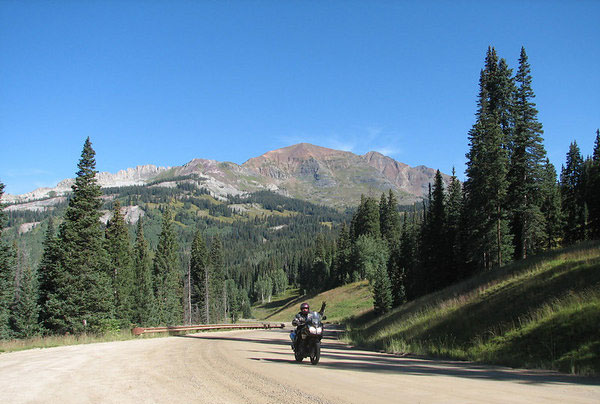
How hardcore are you anyway? Hardcore enough to do the Big Dog?

First let me tell you what the Big Dog Ride is. OK, first of all it’s for BMW riders, so that lets a bunch of us out. What they say on their website is this:

The BIG DOG RIDE is a BMW “Invitational Ride” for owners of BMW G/S and GS model motorcycles. It is neither a race nor a rally. It is an annual gathering of a fraternity of BMW aficionados of G/S and GS styled motorcycles that mutually appreciate riding their motorcycles with like minded philosophers in the best environment for on and off-road riding in the world, the Rocky Mountains of North America.

Then there’s this:

Each year an entrant can expect to ride between 800-1,200 miles on the BIG DOG RIDE over some of the highest, toughest mountain passes in the Rocky Mountain range, sometimes reaching 14,000 feet above sea level. Rain, snow and sleet can be encountered in August, as well as 100-degree heat. The BIG DOG RIDE has been to Colorado, Utah, Wyoming and Montana. Riders often make numerous crossings of the Continental Divide, sometimes fording swollen streams, and riding over snow fields and shale cliffs. It is not unusual for a rider to be in a single-track path no wider than 24 inches, with a drop-off of 1,000 feet on one side and a sheer rock cliff on the other.

And then this:

The BIG DOG RIDE is not for the meek, mild or poseur GS rider. It has rightfully earned the description as being the “highest, toughest BMW motorcycle event in the world.” It is dangerous, and fun. BIG DOG riders can be heard laughing from mountain tops at the start of the event to the finish, as well as from and to their homes, often as far away as Vermont, Florida, Canada and California.

Here’s where the name comes from:

On the second ride one of the errant participants found himself stuck on a snowfield. He had to disassemble his motorcycle to turn it around, then with the help of several others; they pushed, pulled and dragged both rider and BMW back up and over the pass he had come down. The “helpers” were likened to the big Saint Bernard dogs of the Alps famous for rendering assistance to stranded hikers and skiers. After several more mishaps where riders had to be helped by their fellow entrants as they pushed their personal riding envelopes past points of explosion, all the riders came to be known as “BIG DOGS.” The event in the third year was called the BMW GS BIG DOG RIDE, and that’s the name that has remained.

OK. I could go on quoting their website but you can go there yourself and read and see it all. This year’s event is Aug. 14-17. Any Big Dogs out there?

Biker Quote for Today

You start the game of life with a full pot of luck and an empty pot of experience. The object is to fill the pot of experience before you empty the pot of luck.

Ride Your Motorcycle To Work Day Is July 16

Wednesday, April 2nd, 2008

It’s getting toward that time again, so as I always do, I’m cluing you in to this year’s Ride Your Motorcycle to Work day.

This year the date is July 16. As always, that’s a Wednesday, the third Wednesday in July. This is a day to get as many bikes out on the streets and highways as possible, to make an impression on the non-riders as to just how many of us there are. Not for intimidation or anything negative, just to let them know we’re here and that they need to be mindful of us as they drive. I mean, have you ever been on the highway when someone in the next lane pulled into your lane without looking over their shoulder to see if perhaps someone might be there? No, it’s never happened to me either. Right!

So the point is to get out in force and impress upon them that they MUST look, MUST be aware, and MUST share the road. Maybe their lives don’t depend on it, but ours do!

If you really want to get into this, you can go to the website at www.ridetowork.org and download logos and artwork, public service announcements, and various other things to pass along to the local media or put up in public places. Here’s the logo.

Ride to Work Day logo

Who knows, maybe this year I’ll be able to take part. The funny thing is that each year as I’ve promoted this thing, I’ve not been able to participate. Last year I was working a job that had me working at home. The year before that I was on vacation. This year I may be unemployed on that day, but if so I’ll at least get out and ride a bit just for the heck of it.

Anyway, I’ll bring this up again just before the date. In the meantime, take today’s quote with a grain of salt. Maybe.

Biker Quote for Today

If the person in the next lane at the stoplight rolls up the window and locks the door, support their view of life by snarling at them.

“Dirty” Roads Now Shown On Website

Monday, March 17th, 2008

I’ve started adding something new to the website, a listing of good-quality unpaved roads that you can ride even on a street bike.

The instigator for this was Larry Matkovich, who runs Larry’s Custom Cycle in Canon City. He asked why I didn’t have any and I replied that the website was primarily for people on cruisers and street bikes. Larry said he knows of some very nice roads that may be gravel but are easily navigable on street bikes just the same. I told him I don’t know many of these roads but if he could supply the info I would be happy to get it up on the site. Can do, he said.

Well, Larry’s coming through on his promise so I am, too. Check out the Dirt Roads and Side Trips page for what we’ve got so far. And then keep checking back as we add more. Also, if you have any to suggest, just send me the information at ken at motorcyclecolorado.com. Thanks.

New Zealand Rides The Rockies – Day 10

Friday, March 14th, 2008

Recap: Steve and some buddies are coming from New Zealand in 2009 for some motorcycle touring in Colorado and Utah. This series of posts lays out their proposed routes, with my comments. Your comments are welcome as well.

Day 10

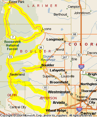
Oh no! This 10-day motorcycle ride around the Rockies is coming to an end. Today is the final day. Dang. Oh well, Steve and the gang are in Golden and need to end up back in pretty much the same place in order to turn in the bikes and head home. Today they’re going to cruise the Peak-to-Peak Highway and check out the canyons leading up and down between this road and the flatlands. They don’t have a detailed route in mind so this can be taken as a possible route. Here’s the map, and the enlarged view.

Peak-to-Peak Highway and adjoining canyons

At day’s end yesterday, our group came down US 6 through Clear Creek Canyon, so we don’t really need to backtrack today. Going north out of Golden on CO 93 it is just a couple miles to the turn-off to CO 46 up Golden Gate Canyon. This is a favorite ride and a great way to start the day. Winding up the canyon, you reach CO 119, which is the southern portion of the Peak-to-Peak. From here we’ll turn north, to the right.

Now, there are any number of ways you could do this ride. I’m going to suggest that they just go all the way to Estes Park in the beginning and then work the canyons on the way back. That means CO 119 as far as Nederland, then CO 72 to where it terminates into CO 7, and then CO 7 to Estes Park. Don’t be surprised coming into Estes Park if you come upon a traffic back-up, there are herds of elk around here that are not shy and everyone stops to look.

From Estes Park we now turn east on US 36. This road goes down the North St. Vrain toward Lyons. At Lyons you just cruise through town and out the other side and you’re back on CO 7, which goes back up the South St. Vrain to where you met it before. At that point it’s time to head south on CO 72, the road you came north on.

Heading south on CO 72 you come (again) to Ward, and the intersection with Lefthand Canyon Drive, or Boulder County Road 94. Go ahead and take this turn. It runs down (surprise!) Lefthand Canyon and comes out to US 36 north of Boulder. Head south toward Boulder but when US 36 jogs to the left, stay straight on CO 7, Broadway. This will be a nicer ride through town.

Broadway leads you right into the middle of Boulder, where you take a right on either Walnut or Canyon and on out of town directly into Boulder Canyon on CO 119. There are a number of places to stop on your way up this canyon, and one of the best is Boulder Falls.

CO 119 reconnects you with the Peak-to-Peak at Nederland. Nederland, by the way, is where the Caribou recording studios were located, where a lot of great music was recorded in the 1970s.

At Nederland we stay on CO 119, which heads south, but very soon turn off onto CO 72, which goes down Coal Creek Canyon. Of course, before it goes down too far it first has to go up and over the crest at Wondervu. Nice switchbacks along here and Wondervu is a good place to stop for a break. Coal Creek Canyon comes out CO 93 at the former Rocky Flats Nuclear Weapons Plant. This plant used to build the plutonium triggers for nuclear weapons, but has been decommissioned and is now undergoing environmental clean-up.

We head south on CO 93 and another short jaunt brings us back to Golden and the end of the last day of this terrific trip. Now — darn! — they’re going to be stuck riding the terrific roads in New Zealand again. Until the next time! See you then.

New Zealand Rides The Rockies – Day 9

Wednesday, March 12th, 2008

Recap: Steve and some buddies are coming from New Zealand in 2009 for some motorcycle touring in Colorado and Utah. This series of posts lays out their proposed routes, with my comments. Your comments are welcome as well.

Day 9

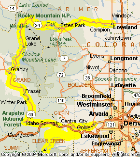
Today is a bit of a contradiction for our riders. It will be one of the shortest days in terms of miles but it will be one of the biggest days in terms of where they’re going. Today’s ride will go over Trail Ridge Road and to the top of Mount Evans, along with some other pretty good stretches. Here’s the map and here’s the enlarged view.

Loveland to Golden, via Trail Ridge Road and Mount Evans

Right off the bat, Steve and the group head out on US 34 up the Big Thompson Canyon. What a nice way to start the day. This beautiful canyon goes up to Estes Park, which, despite the name, is a town, not a park. The park people sometimes get it confused with is Rocky Mountain National Park. We’ll get to that later.

Because this will be the first time for these folks going up the Big Thompson, they’re proably going to want to just ride the whole canyon. If you’ve done it before, however, and are interested in an alternate route, you can take CO 43 between Drake and Estes Park. There are some hairpin turns on this that might make you think you’re in over your head.

At the head of the canyon is Estes Park. This is a very nice town but it has gotten very crowded. Count on slow going through here as you make your way to the entrance to Rocky Mountain National Park. Oh, and that big old lodge you see on the hillside? That’s the Stanley Hotel, where they filmed “The Shining” with Jack Nicholson and Shelley Duval. Red rum anyone?

US 34 continues through Estes Park and into Rocky Mountain National Park and then winds its way up over Trail Ridge Road, the highest through road in the U.S. This road closes for the winter but should be open by the time Steve and crew get there. Trail Ridge Road is one of the must-do rides in all of Colorado. Plan to take your time. You really won’t have any choice, but you won’t want to rush anyway.

The highway comes down from Trail Ridge Road into the town of Grand Lake. This is a very nice town and well worth a stop. From there, US 34 goes on down to where it hits US 40 just outside of Granby. Here Steve and the others will need to make a decision. He’s considering taking a quick run west on US 40 to Kremmling and then back. He just doesn’t want to miss anything. What there is on that stretch is Hot Sulphur Springs and a nice bit of canyon. Is it worth the extra time and miles? I don’t know. They probably ought to check the time and see how much of the day has already elapsed. This may be a short ride in mileage today but it’s far from done at this point.

Whatever they do, eventually they’ll head south on US 40 to Winter Park and then up and over Berthoud Pass. Berthoud is another very nice pass, and the road is in very good condition thanks to a lot of money spent on upgrades in the last few years. From the pass, US 40 runs down to Empire, where it meets I-70.

A short jaunt east on I-70 brings the group to Idaho Springs, where they will get off the interstate onto CO 103 over Squaw Pass. Squaw Pass is a nice ride on its own but the real draw here is that this is the route to CO 5 that takes you to the top of Mount Evans. If you thought Trail Ridge Road was a slow ride, be prepared to go even slower. I don’t recall for sure but I believe the speed limit on this entire stretch is 10 mph. There is also a toll, by the way. That’s OK. It’s worth it, and you pay less for motorcycles. And no matter what time of year it is, don’t be surprised if you get snowed on a little.

After Mount Evans the route continues on CO 103 toward Bergen Park. A left onto CO 74 a few miles brings you to another left onto Jefferson County Road 65, which meets up with I-70 a little east of Idaho Springs. More importantly, it meets up with US 40 at the same spot and it’s really US 40 that we want. US 40 parallels I-70 on the north as it goes down the west side of Floyd Hill. At the bottom of Floyd Hill both roads intersect US 6, which is our ultimate goal.

US 6 winds down through Clear Creek Canyon, coming out at Golden. One of the first things you’re sure to notice is the Coors Brewery. You may even smell the malt before you see the plant. Golden is tonight’s stopping point, so this day’s ride is done.