Archive for the ‘Info to Add to Website’ Category

Witter Gulch Road Is A Ride You Have Got To Do

Thursday, September 26th, 2019

As many times as I have ridden the Squaw Pass road I never noticed this one paved road heading off to the south. But now I’ve got to tell you about it.

Witter Gulch Road

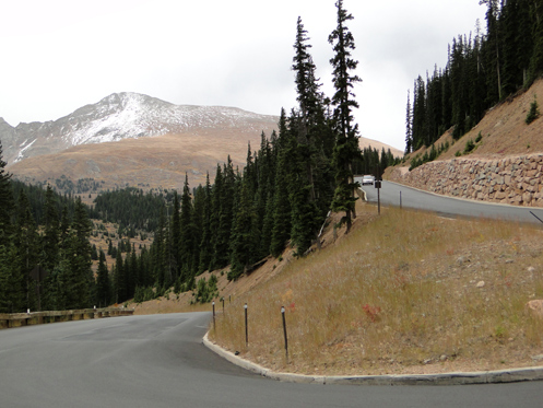
    Can you tell this road is steep?

I was riding with Bob and Robert, the Go Fast Buddies, on an RMMRC Wednesday impromptu ride. Bob proposed Witter Gulch, Robert said that sounded good, and I said I didn’t know Witter Gulch. Apparently that road connects to the Squaw Pass road but Dave wasn’t sure he could spot the turn-off. Then let’s go up it, Robert suggested. Just take the turn by the lake in Evergreen. OK, that will work.

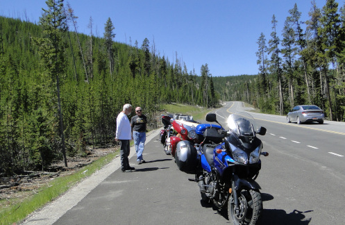
So we got to Evergreen and the turn and Bob kept straight. Robert had been trying to signal Dave that this was the turn but now he just raised his arm, palm up, signaling “Well, OK.”

I guess Dave figured he could find the turn and wanted to go down, not up. We turned onto the Squaw Pass road and at a point where the road curves to the right there was a road to the left and he took it. We followed. This was indeed Witter Gulch Road.

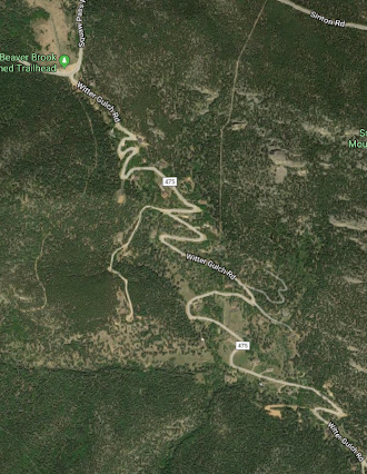
And what a road! Holy crap! You can see in that Google Maps image above how it is one switchback after another. It make sense. The Squaw Pass road at that point runs along a ridge and anything in either direction could only be down. A lot.

Down we went. This is a good road, with excellent pavement. But you’re never going to get up much speed. I hope and presume that Bob was scanning the road ahead because at each switchback he late apexed to the point of going way over into the oncoming lane, while Robert and I just slowed down enough to stay in our lane.

Then there was the point where my attention flagged for an instant and I realized I was scary close to the edge of the road at a point where beyond the asphalt there was only air. OK, put all other thoughts aside until you get down where it’s more level. Dummy.

We got down to Upper Bear Creek Road and now the road followed the creek. There were obviously expensive houses along Witter Gulch Road all the way but now we were into one of those areas where you look around and wonder where in the world all these people got all this money. Ten of me together couldn’t buy one of these houses.

We pulled off at the Evergreen Country Club and agreed it was time to head home. Then on down along Bear Creek to Morrison and off in our separate directions. Thanks for the tip, Bob. I’ll be going back to that road. And I may need to point it out on the website.

Biker Quote for Today

Vinyl Tension-o-meter. Using a vernier caliper you measure the amount of seat vinyl you have sucked into a ridge by rapid contraction of your butt cheeks as the result of a near accident. Also referred to as “pucker factor.”

OFMC Hits The Road For 2019 Trip

Thursday, August 1st, 2019
motorcyclists stopped along the road

The OFMC (just three of us!) stopped along the road.

It was like the early days of the OFMC when Bill and Dennis and I took off for this year’s trip. Originally the group was three of us–Bill, John, and me. John no longer rides and a lot of others who used to ride with us have gone their separate ways so now we are back to three. We miss the camaraderie of the others but riding with three bikes–rather then ten–is a pleasure.

On a blazing hot day we headed west on I-70 and then north on U.S. 40 over Berthoud Pass and down to Winter Park and Granby. Just west of Granby we turned onto CO 125. This road goes over Willow Creek Pass to Walden, in North Park. I don’t have Willow Creek Pass on this website but after riding it a number of times I have concluded I need to add it. We’ll see if I get it done this year or not.

We have ridden Willow Creek Pass north to south before but I’m pretty sure this was the first time we’ve ridden it south to north, so it was sort of the first of several firsts on a variety of roads on this trip. And it was terrific. A really nice road through a very nice area–albeit with about a million dead pine trees–and almost zero traffic.

We stopped for lunch in Walden and as we were getting ready to head onward three other guys on bikes–younger guys–pulled in. Of course we talked. Like us in the old days, they were out for a week and had no plans as to route or stops. And like us back then, if there were no motels available they had their camping gear. The one difference was that they were on much more capable machines and their gear was probably better than even ours is today. For us in the beginning, gear consisted of two gym bags loaded with stuff tied together and thrown over the seat behind us, plus tent and sleeping bag bungeed on.

Heading north out of Walden we entered Wyoming and made our next stop at Saratoga. All we wanted besides to stretch our legs was shade–it was still blazing hot! Then on to Rawlins for the night.

In the morning we expected more heat so we didn’t put on anything for warmth. We were going to be crossing central Wyoming on U.S. 287 and that is usually a long, hot, dry run. And we got cold. In fact, we stopped twice in the first 80 miles to put on more layers because that heat just never showed up. Meanwhile, it was above 100 in Denver that day.

So north and west on 287 as far as Sweetwater Station and then north on WY 135 to Riverton. Then U.S. 26 to Shoshoni and U.S. 20 to Thermopolis. Then finally WY 120 to Cody, our destination for the day. And just a few miles out of Cody it did finally get hot.

Cody was a bustling place. Apparently the hundreds of motorcycles roaring up and down the main street were there in connection with the Beartooth Rally, which we had not been aware of. Of course, this is why we make our motel reservations in January, and this was not the only time we were glad we had done so.

Tomorrow would be crossing Yellowstone National Park. How ugly is that traffic going to be?

Biker Quote for Today

Do you really have to ask why I would want this big vibrating machine between my legs?? – Anonymous Female Racer

Tracking Rides With Rever

Thursday, October 18th, 2018
Rever tracking map

Viewing my first Rever ride from my desktop computer.

I was recently introduced to a new tool that I may very well put to a lot of use on this website. Brought to us by many of the same folks responsible for Butler motorcycle maps, we now have Rever.

Rever is a ride-tracking app for your GPS-equipped cell phone. In brief, you create an account, download and install the app, and then turn it on when you go for a ride. Shut it off when you’re done with the ride and you then have, stored in the cloud, a complete record of your ride, including route, miles, time, average speed, and more. That image above shows my very first ride with Rever tracking me.

It’s dead simple plus it has a variety of uses. Offered in a freemium manner as is so common these days, the basic app is free but if you pay to subscribe it offers a lot more. But at its most basic, you can track rides and also plan rides in advance.

Once you do a tracked ride or plan out a ride, you can save it. Any friends you are connected to on Rever can see your rides. So if you’re taking a group on a ride you have done before, or that you have planned out on Rever, each of your friends can open up that ride and they have the complete route plan right there in their hand.

One issue group riders encounter at times is getting separated. If each of your riders is on Rever and is tracking, lose somebody and you can pull out your phone, go to their rides, and see where they are right now. How cool is that?

For the paid membership you can also get Butler Maps overlays on your map so you can plan the route to hit all the good roads Butler points out to you.

What really interests me about Rever is that back when I built this www.motorcyclecolorado.com website we did not have smart phones that were essentially desktop computers in your hand. But full-sized web pages don’t generally display well on a cell phone. In order to at least not get too far behind technology I have rebuilt the main pages of the site to be mobile-friendly, but that’s only 11 pages out of more than 100.

Of course, the main point of the website is to present the best rides in Colorado. I have created maps but they are static. You can’t zoom in or do anything else other than look at them. With Rever I see the opportunity to create new, mobile-friendly pages for all these routes that should really bring the site more up to date. So look for that to happen over the next couple years.

Meanwhile, in order to present all these routes via Rever maps, I’m going to have to ride them all again. Oh, what a dirty job. Please don’t throw me in that briar patch.

Biker Quote for Today

If you think I’m cute now, wait until you see me on my motorcycle.

A Blast To Home

Thursday, August 16th, 2018

Judy and I were facing a hard day’s ride this day. Not having gone to Red Lodge as we sort of planned to, we really needed to cover ground.

We blasted on I-90 to Columbus, where we went south on Montana 78. The wind was also blasting so this was the windiest day we had had so far. I had been on Montana 78 once, going north, and Judy remarked correctly that it was a lot prettier going south because that way you have mountains in front of you. We figured that to make it a long distance we needed to stop often, even if only for a few minutes, so we stopped both in Columbus and Red Lodge.

Judy at Glacier National Park

Bill tells me Judy is “an amazing woman” because she rode 3,300 miles with me. I agree.

From Red Lodge it was east to Belfry on Montana 308, then south on Montana 72 into Wyoming, where the road became Wyoming 120. South on 120 to Cody (gas stop in Cody) and on south, to Meeteetse (stop for lunch) and to Thermopolis (rest stop).

At Thermopolis we picked up U.S. 20 and followed it south to Shoshoni, then south west on U.S. 26 to Riverton (long rest stop). South out of Riverton we turned southeast on the easy to miss Wyoming 135, which was the start of the really brutal part of the ride. But first the road went up a hill/mesa where we got a fabulous view of the valley and mountains to the west of us. Then it was into the heart of Wyoming’s desert.

At the intersection with U.S. 287 we stopped at the rest area and observed the chip seal going on in both directions on 287. Oh crap. Seeing at one point that the line of cars that had come the way we had come was going to get to move, we hurried to gear up and join them but were just too late. Time to sit, no longer in the shade, for 15 minutes. I guess I didn’t mention that the weather had once again turned blazing hot.

Once we were able to move, we were delighted to find that the chip seal was only going on for about half a mile in our direction. We lucked out there. But then it was a long drone across this barren wasteland in the center of the state. I’ve been across this numerous times and it is never pleasant. Amazingly, the map shows it as a “scenic route.” Someone has a different definition of “scenic” than I do.

The map also showed another rest stop midway between the junction and Rawlins so we planned to stop there but there was no such thing so we rode on the last 80 miles with no breaks. Getting in to Rawlins we were dismayed to find that although the town has many big motels, they were all full. Fortunately a woman at one where we asked looked on her computer and told me the Best Western at the other end of town had two rooms left and they were the last in town. She very nicely went ahead and made our reservation for us and by the time we actually got there the other room had been taken. We didn’t even know what we were paying but we didn’t care. We had ridden 430 hard miles that day and for us that is a lot. We don’t have iron butts.

Heading home the next day, it was going to be a relatively easy day so we didn’t hurry to get going. When we hit the road it didn’t seem windy heading east on I-80 but as soon as we turned south on Wyoming 130 we realized we had simply had a nice tailwind. Now it was a crosswind, and it didn’t let up until we were climbing Berthoud Pass south of Winter Park.

We cruised through Saratoga and stopped at Riverside for gas. Then on to Walden on Wyoming 230, which became Colorado 125 when we crossed the state line. A quick rest stop in Walden and on south on 125 over Willow Creek Pass. I’ve been over Willow Creek Pass several times but have never thought it was grand enough to put on the website but I’ve changed my mind now. This is not a high pass, it’s definitely a minor pass, but it is quite nice and there is almost no development along the way. Just a bunch of hills and forests and streams. Worth the ride for sure. OK, add that to my to-do list.

The road comes out on U.S. 40 just west of Granby so east we went on 40. Got gas in Granby, stopped for lunch in Winter Park, and then over Berthoud Pass and down to I-70 after an ice cream stop in Empire. Then I-70 down the mountain, C-470 south to U.S. 285, east on 285, which becomes Hampden, a right turn, a left turn, and a curve to the right and we were home.

Altogether, 3,310 miles. Great trip. Great to be home. Now tomorrow I’m leaving on the OFMC trip with the guys for another eight days. I’ll take the V-Strom on this one.

Biker Quote for Today

Riding is my meditation, mind flush, cosmic telephone, mood elevator, and spiritual communion.

Guanella Pass Now Has A Page Of Its Own

Thursday, June 1st, 2017
Guanella Pass page.

I just got a new page up for the recently paved Guanella Pass.

Well, it took me awhile. It always does. Guanella Pass has been completely paved for at least a year now, maybe longer, I don’t recall, but I only just now got it up on its own page on the website. Plus, a few days earlier, I set up the Motorcycle Camping on Guanella Pass page, with info about each of the four campgrounds along this road.

Previous to this–and previous to it being paved–I had this pass up on the Dirt Roads and Side Trips in Colorado page. Not any more.

The reason it takes me so long to get these things done is that there is so much involved. First I had to go ride the pass a few times, shooting photos and jotting down pertinent information. Then in the middle of it all I got this GoPro camera so I went and rode it again shooting video so I could include some video highlights of the ride.

Well, you can chalk that one up to learning how to use the GoPro. I won’t bother you with more detail of that, only just say there is no video on the page at this point. And the photos are basically OK for now; I had to patch together a bunch from several different trips up there over the course of several years. At some point I’d like to make it less of a hodge-podge.

I also decided I want to make Guanella the first of a second batch of web pages that are designed to be mobile friendly. Something you can view easily on your smartphone. And along with that I wanted to use an interactive Google map rather than the static Microsoft Streets and Trips maps I’ve always used till now.

Once again, there was a learning curve but I figured it out and that is what this new page has. There is an issue, though, in that at least on my desktop computer the map loads very slowly. Like, five to ten seconds, during which time there is just this empty rectangle. I may swap out the desktop version with a Streets and Trips map, while keeping the mobile-friendly page with the Google map.

And oh yeah, I haven’t got the mobile-friendly page ready yet. You can’t just do a copy and paste. What works on a big screen usually doesn’t work very well at all on a tiny screen.

I won’t bore you either with all the little tweaks necessary to integrate a couple entirely new pages into the overall website. Let’s just say there is a ripple effect that no one but me would even be aware of.

Now it appears they are finally paving the west side of Cottonwood Pass. I guess in about a year I’m going to need to do this all over again for Cottonwood.

Biker Quote for Today

Oh, you ride a motorcycle? That explains why you’re getting so many women.

Guanella Pass Really Is Open Again

Monday, October 3rd, 2011

Guanella Pass

I owe thanks on this one to Steve Farson, author of the newly released The Complete Guide to Motorcycling Colorado. I reviewed his book last week and mentioned that he did not tell his readers that Guanella Pass is closed. They closed it in 2008 and the most recent thing I had heard was that there were no plans to reopen it.

Well, what do you know, Steve emailed me to thank me for the positive review AND to tell me that in fact, Guanella was reopened earlier this year. Finally. And he said the road was beautiful, that they have done a terrific job.

Of course Judy and I had to go see for ourselves, and we did on Saturday.

Holy smokes, what a nice road! The asphalt is beautiful, there are a lot of guard rails where there didn’t used to be any, and the new retaining walls are impressive. On top of that, the pavement goes a lot farther than it used to. Used to be, it was paved all the way to the top on the Georgetown side and then just over the crest it turned to gravel. Then it was gravel all the way to Grant, except for some spots where the asphalt from many years ago was still holding together a little.

We checked it on the odometer and here’s what we found. From the top headed toward Grant, the new pavement extends another 3.8 miles. At 8 miles from the top the old surviving pavement starts to get bad and at 9.2 miles it ends altogether. There are then 3.6 miles of gravel before you hit pavement again 0.5 mile from Grant.

So there’s really no reason not to ride this pass. The 3.6 miles of gravel are easily traversable on any street bike as long as you take it nice and easy. Heck, before they closed it for nearly 3 years I used to see Harley baggers and everything else up there, and there was a lot more gravel back then.

Truth is, this road is so much better than it was before I’ve concluded I need to promote it on the website from just a “Dirty Road” mention to its own full page. Look for that sometime next year, as I doubt I’ll have time to get to that right away.

Thanks for the update Steve.

Recent from National Motorcycle Examiner
‘Mythbusters’ reiterates previous ‘bikes not greener’ conclusions

Biker Quote for Today

So many roads, so little time!