Going Down (And Down And Down) Douglas Mountain Drive
Thursday, July 22nd, 2021I mentioned this road on Monday and promised more info right away, so here we are: Douglas Mountain Drive. I was jazzed enough by this road that I went out a couple days later and rode it again, this time with my regular camera and my GoPro camera.
As before, I headed up Golden Gate Canyon Road. It was a great day to be out riding, with a lot of heat in the city but much cooler up higher. Plus, there was not a bit of traffic in front or behind me so I could cruise at my own easy speed.
I reached the well-marked turn to the left to go up Robinson Road and made the turn. A sign warned of road work ahead and there was, but just minor shoulder work and the flag man flipped his sign to send me right on up. All clear after that.
The road does enough serious climbing that I figured I would need to ride it in the other direction some time. You go on up and over a crest and then, what a surprise, you’re in an alpine park that is a neighborhood. Who knew so many people lived up here?
On through the park and I came to a place where Robinson Road goes off to the right but the pavement goes to the left, now becoming Douglas Mountain Drive. A “Pavement Ends” sign could lead you to believe the pavement would end soon but that must apply to Robinson Road, up ahead, which goes to gravel immediately. If you’re not paying careful attention you won’t notice the change and wonder about the sign.
Douglas Mountain Drive continues on over a ridge and then you come to another “Pavement Ends” sign. This one is for this road but it really ought to read “Pavement Maintenance Ends.” I suspect the county decided to cease maintaining this road but it will be years before it totally degrades. Right now it is paved all the way, though in need of some repair. Not a problem, you just steer around the potholes.
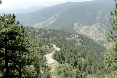
And then it goes down. And down and down, at steep angles with hairpin curves. And great views. And look at all the houses built on the steep sides of the hills!
I stopped right where the two roads split and that’s when I turned on the GoPro. You can watch the video of the whole ride down to where it hits Colorado 119, the Peak-to-Peak Highway, just past where US 6 goes left to head to Idaho Springs. A nice ride.
I got to the bottom and didn’t really relish running down Clear Creek Canyon so I turned around and went right back up. That also gave me the opportunity to check out Centennial Cone Park, which is part of Jefferson County Open Space. The road to that branches off just a short ways up the hill. It looks like a very nice place but if you’re going to hike the whole loop it’s about 14 miles.
Then a nice ride down to Golden Gate Canyon Road and another cruise down the canyon with zero traffic in front or behind. And then into the heat of the city.
Biker Quote for Today
“I want to ride my motorcycle up the side of the Luxor to the light and vanish.” ? Criss Angel

