Posts Tagged ‘Guanella Pass’

A Day Ride From Eagle

Thursday, June 28th, 2018
map of route

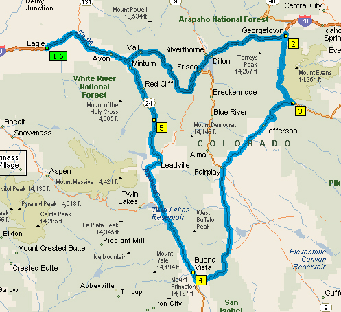
A day ride from Eagle.

Living in Denver I am well acquainted with just about any day ride you can make from here. But I was up in Eagle this week visiting my friends Willie and Jungle and they decided to take a day ride. Oh, that puts a very different perspective on that idea.

I had ridden up there the day before and just took I-70 so as to get there. I was disinclined take the slab home, however, so it fit my plans perfectly to accompany them on their ride to the point where I would peel off for home.

Leaving Eagle we stuck to old U.S. 6, paralleling I-70. Who wants to ride on the interstate when you don’t have to? U.S. 6 does get very urban, however, when you get to Edwards (we were headed east) so we did jump on the big road there, just for two exits, to the Minturn exit.

Then it was U.S. 24 over Tennessee Pass to Leadville, and down over to Buena Vista. Certainly I’ve been on that road more than once before but it is not a common route for me so it was very nice to be out there.

As we reached Buena Vista and turned east on U.S. 285 it occurred to me that for Willie and Jungle, this stretch must be a piece they don’t get to often. I mean, they never go to Denver and that’s where this road heads. For me on the other hand, this is an extremely common stretch of road that I traverse probably at least a dozen times every year.

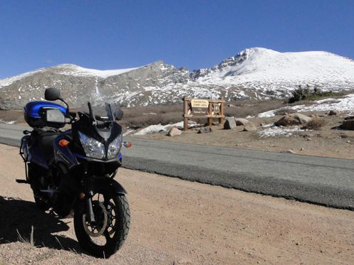
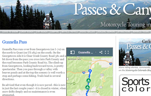
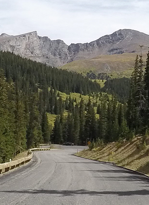
So we headed east and stopped in Fairplay for lunch. They could have gone north there over Hoosier Pass to Breckenridge but these people are serious riders and that would not have been a long enough ride. So we continued east from Fairplay over Kenosha Pass and down to Grant. This was where we parted. I continued east to Denver and they turned north over Guanella Pass to Georgetown and then headed west to Eagle on I-70, with a side-trip planned to go over Loveland Pass, rather than through the tunnel.

Of course, living in Eagle, Willie and Jungle have numerous day trip options. I have ridden with them other times when we went to Leadville, down to Twin Lakes, over Independence Pass to Aspen and Glenwood Springs and then back to Eagle. Also over to Wolcott and up to Toponas and over Gore Pass, then Rabbit Ears Pass to Steamboat Springs, and back to Eagle.

Whereas, living in Denver, as I do, the first part of nearly every trip is just getting across town to get into the mountains, and then coming home I’m largely restricted to the two major routes, I-70 and U.S. 285. But I suspect wherever you live it gets to be the same old, same old, riding the same routes again and again. Anybody want to swap houses for a year so we can both explore new roads?

Biker Quote for Today

Some important things in life just require a deep breath and a long ride with friends.

Last Ride In The Hills This Year?

Thursday, October 12th, 2017
motorcycle in the mountains

A beautiful day on the pass, even if I was too late for fall colors.

Sunday was warm and sunny, and you could still ride up onto Guanella Pass. I know, because I did. By Monday, not true. This may have been my last ride in the mountains in 2017.

I had been wanting to get up in the hills to enjoy some of the fall color but with my Mom ill I had been in South Carolina for awhile. Then I got back and we had almost two solid weeks of overcast and rain–not at all like typical Colorado weather. Finally the sun came out but other demands kept delaying me, until I realized it was Sunday or not at all. I geared up and headed out.

Not that I really geared up sufficiently. Heading out of town across Hampden/U.S. 285 I was already getting chilly but I did have my electric vest on so I flipped it to on. I was wearing long underwear and had multiple layers on top, but only my least warm gloves. And I had intended to wear my leather chaps but forgot them as I got ready.

No matter, the vest really did the job. With it pumping out heat, everything else abated.

My intention was just to run up Guanella Pass from the Georgetown side and then back the same way. I had other things I needed to do at home and going down to Grant and home on 285 would have taken a lot longer. But I began reconsidering as I saw all the traffic streaming down on I-70 and realized it was the dreaded Sunday afternoon. Maybe I better rethink this.

Off I-70 at Georgetown and starting up the pass. I didn’t really know for sure if the road was clear or if maybe it had ice on it at places. Turns out it was completely free of that kind of slippery stuff but in all — and I mean all — of the switchbacks there was plentiful gravel, obviously spread there to improve traction–for cars, not motorcycles. Take it slow; not a problem.

The V-Strom is a fun bike to ride on twisting mountain roads. It is (relatively) light and agile and every time I got clear of traffic in front of me I was able to whip it (except on the switchbacks). This is what makes riding in the mountains so fun. There were very strong winds in just a few spots but not for the most part. What caused those isolated blasts? Heck if I know.

So before I even got to Georgetown I knew I was too late for any color up on the pass, but there was snow alongside the road and on the hills, so that was a different kind of beauty. And the top of the pass is particularly scenic, as you can see to an extent in that photo above. Still worth the trip, especially if the real purpose of the trip was just to go for a ride.

I did decide to go back the way I came and then I was surprised to find that the dreaded Sunday afternoon traffic was absent. Maybe because Monday was Columbus Day and a holiday for some, and/or maybe because it is mud season, where it is too early to ski but too late to camp or do so many other summertime mountain activities. Whatever the reason, I blasted back down into town rarely going slower than 65. Often a good bit faster.

All in all, a nice day on the bike.

Biker Quote for Today

Life is not about waiting for the storms to pass, it’s about learning to ride in the rain.

Guanella Pass Now Has A Page Of Its Own

Thursday, June 1st, 2017
Guanella Pass page.

I just got a new page up for the recently paved Guanella Pass.

Well, it took me awhile. It always does. Guanella Pass has been completely paved for at least a year now, maybe longer, I don’t recall, but I only just now got it up on its own page on the website. Plus, a few days earlier, I set up the Motorcycle Camping on Guanella Pass page, with info about each of the four campgrounds along this road.

Previous to this–and previous to it being paved–I had this pass up on the Dirt Roads and Side Trips in Colorado page. Not any more.

The reason it takes me so long to get these things done is that there is so much involved. First I had to go ride the pass a few times, shooting photos and jotting down pertinent information. Then in the middle of it all I got this GoPro camera so I went and rode it again shooting video so I could include some video highlights of the ride.

Well, you can chalk that one up to learning how to use the GoPro. I won’t bother you with more detail of that, only just say there is no video on the page at this point. And the photos are basically OK for now; I had to patch together a bunch from several different trips up there over the course of several years. At some point I’d like to make it less of a hodge-podge.

I also decided I want to make Guanella the first of a second batch of web pages that are designed to be mobile friendly. Something you can view easily on your smartphone. And along with that I wanted to use an interactive Google map rather than the static Microsoft Streets and Trips maps I’ve always used till now.

Once again, there was a learning curve but I figured it out and that is what this new page has. There is an issue, though, in that at least on my desktop computer the map loads very slowly. Like, five to ten seconds, during which time there is just this empty rectangle. I may swap out the desktop version with a Streets and Trips map, while keeping the mobile-friendly page with the Google map.

And oh yeah, I haven’t got the mobile-friendly page ready yet. You can’t just do a copy and paste. What works on a big screen usually doesn’t work very well at all on a tiny screen.

I won’t bore you either with all the little tweaks necessary to integrate a couple entirely new pages into the overall website. Let’s just say there is a ripple effect that no one but me would even be aware of.

Now it appears they are finally paving the west side of Cottonwood Pass. I guess in about a year I’m going to need to do this all over again for Cottonwood.

Biker Quote for Today

Oh, you ride a motorcycle? That explains why you’re getting so many women.

Shooting Guanella Pass With The GoPro

Thursday, September 15th, 2016

I’ve mentioned a few times that I got this new GoPro camera for a Christmas gift and my long-term goal is to provide video of the various passes and canyons featured on this website. So it seemed the perfect thing to do to provide that right from the start when I put up this new page on Guanella Pass.

Guanella Pass

In the past I would have had to stop to get this photo. Now I can just look at the scene I want and it gets photographed.

The issue is, I’m still learning how to use this thing. I’m trying to meet two specific objectives.

  • I want the video in time-lapse because I don’t figure many people are going to be interested in watching a 45-minute video of someone riding over some pass.
  • I want to be able to extract individual images to use as still photos.

So far, I’ve done a few test runs, crossing Cherry Creek Dam and riding up and down Lookout Mountain. And I used the camera to film a ride through Glenwood Canyon this summer. But I’m still figuring out what works best.

Not sure what settings I’ve used previously, I reread the user manual for about the 15th time and decided I should use the multi-shot mode, set to time-lapse, with a frame rate of two frames per second. I’m going to jump ahead here. Suppose I took 40 minutes to go over Guanella Pass in one direction and another 40 minutes going the other way. Do the math at two frames per second and what I ended up with was about 9,600 individual photographs. Yow! Do you have any idea how hard it is to find one particular photo out of 9,600?

And then I ran into an issue. When importing the images from the camera to the computer it stalled at one point saying there was a problem. And there was. There were several groups of images that could not be opened, imported, or even deleted. Something went wrong.

Of course, this made this a learning opportunity. I recalled that my GoPro Hero4 Black can do time-lapse videos automatically, but older models could not, so I reasoned that the GoPro Studio software must be able to turn those images into a video. All I had to do was figure out how. Which I did, and because the sequence where I came up to the pass itself and started back down was all OK I did create a video of just that part of the ride. That’s probably all anybody’s interested in anyway.

But then I also learned that the Hero4 Black has a new setting just for this, called time-lapse video. That’s the setting I should have used.

Whatever. So I did have plenty of still images to choose from and that one above is an example. It looks fine in this size but would not look good enlarged much more. I don’t even know what resolution setting I was using; I need to figure that out and use the highest possible resolution.

So bottom line, I’m learning via trial and error but this is another thing I hope joining the Rocky Mountain Motorcycle Riders Club may do for. Hopefully, someone in the club has more experience than I do with GoPro cameras and can help teach me. That’s my hope, anyway. We’ll see.

Biker Quote for Today

Ride ’em or weep.

Adding Guanella Pass To The Website

Monday, September 12th, 2016
motorcycles on Guanella Pass

Were you riding on Guanella Pass last week? Is this you? This was shot with the GoPro sitting on top of my helmet.

When I first built the Passes & Canyons website I had all I could do to just ride, photograph, and write about all the paved roads over passes and through canyons in Colorado. Anything unpaved was just left out, at least for the time being. Then after awhile I did add the Dirt Roads and Side Trips page, with a few dirt roads.

One of the roads on that page was Guanella Pass. While the road on the Clear Creek County side coming up from Georgetown was paved, heading down to Grant on the other side, in Park County, was not. So it didn’t get a full page of its own.

But guess what! Guanella Pass has now been paved all the way. And it’s a really nice ride, not that far from the city. If you haven’t been over it you owe it to yourself to do so. Probably the best direction is from Grant to Georgetown because that way you come down the steep descent into Georgetown and it’s a good view.

So now I need to add Guanella Pass to the website as its own full-blown page. And the first step in doing that would be to ride the route, shoot photos, and gather information. That’s what I did last week. In fact, I didn’t just ride it, I rode it twice, from Grant to Georgetown and then back to Grant. I was shooting the ride the whole way with my GoPro camera and a road looks different going one way than it does going the other way.

Now, of course, I need to build the page. And it will really be a matter of building two pages, because there are four campgrounds along this road and I’ll also do a “Campgrounds along the Guanella Pass Road” page with information about those campgrounds. And then there’s the whole ripple effect of all the other pages that will need revisions to include these new pieces.

So, it was a beautiful day and I loved getting up in the hills and having a good ride. I was interested to see how the fall color was going but there really wasn’t much to see. I saw some stands of aspen that were still green, but the ones I saw that were turning were very pale. I didn’t see any at all that were the brilliant yellow that makes this time of year so beautiful.

I know the weather has an impact on how brilliant the colors are and maybe this year we’re just not going to have all that much color. That will be a disappointment if that’s the case. And I know the Georgetown side of Guanella Pass can be spectacular. I guess we’ll see.

I’ll let you know when the new Guanella Pass page is up on the website.

Biker Quote for Today

Yesterday is history, tomorrow is mystery. Ride and live today.

Guanella Pass Now Completely Paved

Monday, September 28th, 2015
parking jam on top of Guanella Pass

Saturday afternoon on a gorgeous fall day is very crowded on top of Guanella Pass.

I reported a little over a year ago that Guanella Pass was finally being paved all the way from Georgetown to Grant, and that it would take a year or more before it was completed. Now I’m back to report that the work, if not totally completed, is largely done and the road is asphalt the entire distance. If you’ve never ridden Guanella then you should now because you have no reason not to.

Especially at this time of year. It is absolutely gorgeous up there.

Judy and I did exactly that on Saturday. I had checked for reports on the construction work and found conflicting information. One report seemed to say that the intent was to leave the last two miles to Grant unpaved. Why? Is that really the case? I decided to take the V-Strom just in case.

Our intent was to go out I-70 to Georgetown and get off there to catch the Guanella Pass Road at Georgetown. What we did not count on was a huge traffic jam on I-70. We were coming back into town on Tuesday and saw westbound I-70 backed up for a long, long way but we figured it was an accident of something. Apparently not. Although there is road work in progress along the way to Idaho Springs, this was Saturday and there was no work going on at the time and there were no lane closures. Nevertheless, getting from Evergreen Parkway to Idaho Springs took about an hour. We would have done much better to have gone over Squaw Pass and down to Idaho Springs that way.

autumn vegetationOK, so we finally got to Georgetown. Heading up the pass we knew the road was good because that portion was repaved a couple years ago. We thought there might be a lot of traffic because of people out viewing the aspens but that wasn’t the case, maybe because the trees were mostly past their prime. Closer to the top, however, the autumn colors of the other vegetation was stunning. Here’s an example (although the photo really doesn’t do it justice).

Right at the top it was a total zoo. There are several hiking trailheads at the top and on such a glorious fall day, and a weekend day, the hikers were out in force.

We didn’t stay on top for long, though. What we wanted to see was down the other side. And down we went. And down and down and down. The road is paved, it has a lot of serious landscaping with curb in some places, stonework where they made cuts on the sides of the road, and new fencing along the equestrian area you pass by.

Importantly, the last two miles have not been left gravel; it is paved all the way to Grant. So you know what this means: I’m going to need to create a page for Guanella Pass on the website, rather than just have the brief mention in the Dirt Roads and Side Trips page. That will probably have to wait until next spring so I’ll have time to get up there and shoot a lot of photos and develop all the other information that goes on those pages.

But Guanella is now rideable, even if you hate gravel. Until the snow comes. It closes in the winter. Head on up sooner, rather than later.

Biker Quote for Today

The twisties, not the superslabs, separate the riders from the squids.