Archive for the ‘Colorado motorcycle rides’ Category

A Pleasant Wednesday Morning Ride

Monday, November 25th, 2019
Chambers Reservoir

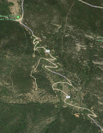
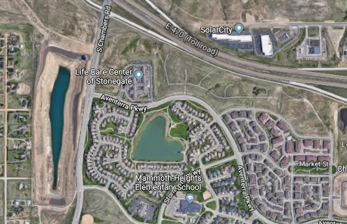
An aerial shot from Google Maps showing Chambers Reservoir.

There was a Wednesday morning RMMRC ride scheduled last week so I climbed on the V-Strom and rode on over to the breakfast place. Although I learned later that there were several folks inside, none of them had come on their bikes. I intended to ride and with no bikes in the parking lot I saw no reason to go inside. I headed out.

It was a cool, crisp morning but I was wearing warm gear so it wasn’t uncomfortable; rather, it was invigorating. But I was darn glad to have my electric vest.

Where to go? It gets harder and harder to go places I haven’t been before. I headed out Parker Road. As I approached E-470 I thought about the road that crosses Parker just south of the highway, Pine Lane. I had been east on Pine but never west. Where does that go?

I turned right to find out. Passing Jordan Road, Pine Lane becomes Aventerra Parkway and starts winding around through a housing development, eventually hitting a T intersection at Chambers. Turning right would have been to head back toward town; I turned left, south.

Right there along the west side of Chambers there is a huge hole in the ground. It looks like a reservoir, maybe, but maybe it’s just a flood control collection pond. It’s long and narrow and really deep, and was completely dry. It also looked like freshly turned earth, as if it’s still being dug, although in a satellite image I see water in it.

(OK, some research shows me it is the Chambers Reservoir, which is undergoing rehabilitation, involving grading, installation of drainage improvements, and construction. Ain’t the internet great!)

Heading south I soon passed Lincoln Avenue. Now I was on totally familiar ground once again. Reaching Hess Road I turned west.

Hess Road runs past the Rueter-Hess Reservoir up into the highlands around the dam that made the reservoir feasible. Cruising through here you have an uncommon–and probably doomed–opportunity to see a section of the Colorado plains that as it was before the city arrived. It’s amazingly pretty. Too bad this whole area will presumably be covered in subdivisions and shopping plazas in about 10 years.

Hess winds around and then terminates at I-25. Continuing on the other side of the interstate the road becomes Castle Pines Parkway. But just before I-25 I turned north on Havana, which parallels the interstate for maybe four miles up to Ridgegate Parkway. I jogged east on Ridgegate and then continued north on Peoria.

This brought me up to County Line Road and the south side of Arapahoe County Airport, which I jogged east to get around. From there it was Potomac north and on back home. Just a one hour or so ride but really nice on this cool, very nice morning.

Biker Quote for Today

100 Reasons not to date a motorcyclist: The way we look at our bike reminds you of the way we used to look at you.

A Kindred Soul?

Monday, November 18th, 2019
motorcycles in Kiowa

Parked across the street from Patty Ann’s.

I went for a ride with the RMMRC Friday and leading the group was Tim. Now, I’m terrible with names, and after being a member of the group for about three years I still probably only know about six or seven peoples’ names. But I think I’ll remember Tim because he is really short, so my mnemonic device to remember his is “Tiny Tim.” You don’t have to mention that to him.

It was supposed to be a beautiful November day but starting out it was overcast and cooler than expected. I dressed warmly and was glad I did. Love that electric vest.

The intent was just a simple ride out to Kiowa to have a late breakfast at Patty Ann’s. I’ve eaten at Patty Ann’s several times and they have great food. If you’re out that way–or if you want to head that way just to eat there–Patty Ann’s gets my hearty recommendation. They have terrific green chile and with everything else smothered in green chile it probably really doesn’t matter what that everything else is.

So the discussion was on the route to get there. The easy and direct–and boringly familiar–route would be to go out Parker Road to Franktown and turn east. That was suggested but Tim didn’t like that idea. He took the lead.

We worked our way southeast, zigging and zagging as you have to do with straight roads on a grid, but we came to a spot where I think everyone expected to go east and Tim headed west. That tipped me off. A couple years ago Roy had staged a mystery ride and we ended up out in these parts. Tim had helped Roy plan that ride. I suspected we were about to take a portion of that ride again.

When we made a left turn at a particular spot I knew I was right. From that point on all the way to Elizabeth we followed the mystery ride route. And it was a lot more interesting than just Parker to Franktown and east.

Kiowa, Patty Ann’s, and the food did its job and we were ready to leave. What route? Again, Tim had no intention of retracing our steps. So he led us along some other roads out here.

What this all told me was Tim must be a kindred soul to me because while I would guess most of the guys had little idea exactly where they were, I pretty much knew every bit of it. You see, I go out there and ride around on these roads exploring quite a bit. And I had just been out here in the past week. These were several of the same roads I was on just days before.

I guess I’m not the only one who loves to explore.

Biker Quote for Today

I got my own reasons why I do what I do. I like to ride motorcycles. She likes it too. — Alan Jackson

Exploring Beyond The Blacktop

Monday, November 11th, 2019
muddy County Line Road

I was not up for the mud on this day–later!

Once again I took off with no idea where I was going to go. Somehow I figure it out. Today I was on the V-Strom.

Here’s an idea. I know on the way south on the Kiowa-Bennett Road there is a point where the road jogs west and if you wanted to you could continue west on whatever road that is. I know I’ve always expected that some day I would take that road and see where it comes out. Maybe today is the day. I headed out Parker Road and then turned east on Hampden.

Now, here’s how my thinking goes. I got to wondering, how far east does Hampden go? Have I ever taken it out as far as I could? Maybe I had but I couldn’t remember. So let’s do that.

Well that didn’t last long. Hampden ends out on Gun Club Road where it runs into a huge landfill operation, Trash Mountain in my parlance. Back to plan A. I turned south on Gun Club to Quincy and then turned east again.

I knew I’d been out this way before and a couple names I was familiar with came along: Tom Bay Road and Brick Center Road. I had checked them both out before and they both quickly go to gravel. Now I went past them until I reached Kiowa-Bennett and turned south.

The jog came at County Line Road. I didn’t know this at the time because there were no signs to that effect but I continued west. Right away there was a sign saying the pavement was ending. That jogged a memory that perhaps I had tried this once before and–not being on the V-Strom–turned around. Well I was on the V-Strom now so no turning around today.

It was a good gravel road, although the surface varied, with some loose sand, some washboard. I don’t know how far I went–at least five miles–and it was a pretty area.

And then there were the construction zone signs. No problem, I can deal with that. But although I never saw any construction equipment, I came up on the area where they had been working and it was all mud. Oh yuck.

Now, I had the bike and the tires to do mud. What I did not have was the riding skills and experience. But there’s no better way to get the experience . . .

On another day I might have done it, but this day I turned around. It was Tuesday and the forecast was for warm and dry so maybe by Saturday, which was also forecast to be in the 60s, maybe it will be dry and I can ride it then.

As I headed back I saw a sign for Brick Center Road. Really? Does that come all the way through? That would save me having to go all the way east to Kiowa-Bennett. But what kind of condition is it in? I guess I’ll find out on Saturday.

So Saturday came and I headed back. Turning south on Brick Center Road I found it to be about the best gravel surface you could hope for. Smooth, solid, and not a lot of loose gravel. As if perhaps it got graded recently.

Brick Center ended at the road I was headed for and I turned west again. I reached the construction zone and although I was totally psyched up to do the mud today if necessary, everything was completely dry. I cruised on and was surprised to find that in less than a mile I reached pavement. What do you know.

Cruising further and further west the road signs kept reading County Road 194. Finally, when I reached Delbert Road the sign said County Line Road. So that was my answer. Not that it ran into County Line Road over by I-25. Just past Powhaton Road it became Sampson Gulch Way and wound its way through a housing development. It hit a T intersection at Aurora Parkway, I went north, and soon came to Arapahoe. I headed west on Arapahoe and on home.

Biker Quote for Today

Why motorcycles are better than men: If your motorcycle is misaligned, you don’t have to discuss politics to correct it.

Another ‘Where Does That Road Go’ Ride

Monday, October 28th, 2019

Oh my goodness, Indian Summer has come and gone, just that quickly. Now the forecast in Sunday’s paper is calling for a high over the next week of 38 and a low–on Wednesday–of 2. Yikes! About the only motorcyclist likely to be out in all this is Dom Pacheco. With his Ural sidecar rig he goes out in anything.

But I did my best to take advantage of the warmth while it lasted. As I had been coming up or going down U.S. 83 the last few times I had noticed a road that ran off a bit to the northeast just where the highway runs off to the northwest. Where does that road go?

Well, I actually learned where it went another time when I saw that it intersects U.S. 83 again further north just a little south of Franktown. But that still didn’t answer the question of where it went in between. I had to find out. I had no choice in the matter. The world simply requires some things of each of us. This is my own personal burden.

So I headed south on 83. It was a wonderful, delicious Indian Summer day and I intended to take advantage of it.

Down to the south junction I went, intending to head north. I could have come the other way but this was how I chose to do it. I suspected correctly that this was a saving the best for last move.

It’s pretty much open prairie at that junction and that was the way it was as I turned north. But you’re also right about at the Palmer Divide, so it’s high prairie. And sure enough, it didn’t take long until I was in the hilly, wooded crest line of the Palmer Divide. And just as in the Black Forest area further west, it was beautiful. And that beauty is not lost on a lot of people who have built very pricey homes in the area. Wow, was it gorgeous.

All too soon, though, the road turned west and led me back to U.S. 83. I didn’t want to just go back the same way I came so I jogged north just to Franktown and took the road west toward Castle Rock. Nearing the main part of town I came to one of those housing developments and I know they all are built these days with a central road running all the way through them. Hey, I’m exploring, so let’s just cruise through this development.

Well, this development is still being built so that road only goes so far. I wandered my way back out to the highway. Then I got to where I had to make a choice and my choice led me into the main part of the old town. But here was a road heading north that I had never been on. Let’s take it.

So I wound through a very nice, hilly area to the east of the Castle Rock outcropping and once again it was an interesting and somewhat scenic route. You can zoom in on that map above and see exactly where I went.

From Castle Rock I didn’t want to get on I-25 to get home so I wandered my way north. You can see that on the map above, too.

All in all it was a pretty darn nice way to spend an Indian Summer afternoon. Too bad there don’t appear to be many more of those in store for us.

Biker Quote for Today

Well, I might go get me a new tattoo or take my old Harley for three day cruise. Might even grow me a fu man chu. — Travis Tritt

Loving Indian Summer

Thursday, October 24th, 2019
motorcycle on Owl Creek Pass

No better time than now to ride!

We had bitter cold weather and now the temps are back up in the high 70s and low 80s. It’s Indian Summer. This weather is literally the reason I live in Colorado.

Back a long time ago I graduated from college and then set out on some serious traveling. In the course of that traveling I spent some time in Colorado. I didn’t fully understand it then but by chance I was here during Indian Summer, a time when the days are just glorious and being outside is being in heaven.

When I decided I was really to stop and put down some roots I asked myself where I had been that I liked the best and the very easy answer was Denver. And here I am.

Well folks, we’re in Indian Summer and it is just as awesome as it usually is, which is to say, to the max. I’ve been getting out on one bike or another as many days as I can and the riding is beyond wonderful.

The days are starting out cool, so you have to layer up starting out in the morning, but by about noon you’ll be shedding layers. On Wednesday last week I knew it was going to be a very warm day but the morning was chilly so I put on my electric vest, a sweatshirt, and a leather jacket. I also wore my riding pants but zipped up the vents and wore long underwear underneath.

And it was indeed chilly starting out, but long before noon I was unzipping vents in the pants and the jacket and at a stop I removed the sweatshirt altogether. I wish I had removed the vest, too, because a bit later than that I started to roast.

But the ride! Ooooh, the ride! The air is just so sweet, the fall colors so gorgeous. And the weather just balmy.

This is why I came to Colorado. It’s also a big part of why I stay. If you’re not out riding in this weather you’re missing some of the best riding of the entire year. What are you waiting for?

Biker Quote for Today

Motorcycle fever has almost drove me insane — David Allan Coe

Witter Gulch Road Is A Ride You Have Got To Do

Thursday, September 26th, 2019

As many times as I have ridden the Squaw Pass road I never noticed this one paved road heading off to the south. But now I’ve got to tell you about it.

Witter Gulch Road

    Can you tell this road is steep?

I was riding with Bob and Robert, the Go Fast Buddies, on an RMMRC Wednesday impromptu ride. Bob proposed Witter Gulch, Robert said that sounded good, and I said I didn’t know Witter Gulch. Apparently that road connects to the Squaw Pass road but Dave wasn’t sure he could spot the turn-off. Then let’s go up it, Robert suggested. Just take the turn by the lake in Evergreen. OK, that will work.

So we got to Evergreen and the turn and Bob kept straight. Robert had been trying to signal Dave that this was the turn but now he just raised his arm, palm up, signaling “Well, OK.”

I guess Dave figured he could find the turn and wanted to go down, not up. We turned onto the Squaw Pass road and at a point where the road curves to the right there was a road to the left and he took it. We followed. This was indeed Witter Gulch Road.

And what a road! Holy crap! You can see in that Google Maps image above how it is one switchback after another. It make sense. The Squaw Pass road at that point runs along a ridge and anything in either direction could only be down. A lot.

Down we went. This is a good road, with excellent pavement. But you’re never going to get up much speed. I hope and presume that Bob was scanning the road ahead because at each switchback he late apexed to the point of going way over into the oncoming lane, while Robert and I just slowed down enough to stay in our lane.

Then there was the point where my attention flagged for an instant and I realized I was scary close to the edge of the road at a point where beyond the asphalt there was only air. OK, put all other thoughts aside until you get down where it’s more level. Dummy.

We got down to Upper Bear Creek Road and now the road followed the creek. There were obviously expensive houses along Witter Gulch Road all the way but now we were into one of those areas where you look around and wonder where in the world all these people got all this money. Ten of me together couldn’t buy one of these houses.

We pulled off at the Evergreen Country Club and agreed it was time to head home. Then on down along Bear Creek to Morrison and off in our separate directions. Thanks for the tip, Bob. I’ll be going back to that road. And I may need to point it out on the website.

Biker Quote for Today

Vinyl Tension-o-meter. Using a vernier caliper you measure the amount of seat vinyl you have sucked into a ridge by rapid contraction of your butt cheeks as the result of a near accident. Also referred to as “pucker factor.”