Archive for the ‘motorcycle touring’ Category

Riding a Kawasaki Versys: A Change of Pace

Monday, July 20th, 2009

I’ve never been a dual-sport kind of guy, mostly because I haven’t had the opportunity. Well, I had the opportunity over the weekend.

On top of Hoosier Pass with the KLR and VersysI hooked up on Friday with Sue Slate, the National Program Chair for the Women’s Motorcyclist Foundation. Sue is in Keystone from now through the end of the International Women & Motorcycling Conference and I dropped by to talk with her about the Adventure for the Cures ride she has organized.

This ride will take a dozen experienced riders with very little, if any, experience on dirt on a tour of the Colorado mountains. The mix is expected to be about 80 percent dirt/gravel and 20 percent pavement. Each rider had to commit to raise at least $2,000 for breast and ovarian cancer research, as well as pay a sign-up fee of $400. The “Dirty Dozen” begin their ride on Aug. 10 and will end up back in Keystone for the start of the conference.

So I met up with Sue, and we talked about the ride and about her motivation for doing the fund-raising that she does, and mostly about her total passion for motorcycles. Sue got her first bike at age 19, used to ride observed trials, and lives and breathes motorcycles. As a public school teacher she used to ride to work every day, would bring motorcycle engines into class as a way of showing unmotivated students that even a motorcycle mechanic needs to be able to read, write, and do math.

Now retired from teaching, Sue works ceaselessly for the WMF and also finds time to be an on-call employee for Kawasaki, working at various motorcycle events around the country.

We covered it all and then she asked me what I was doing that afternoon. I had nothing planned, and was wondering that question myself, because I was in Keystone with my wife, who was there for a conference. “Do you want to go for a ride?” Sue asked.

Of course I did, but I hadn’t planned on doing so and I didn’t have any gear with me. No problem, Sue had extra gloves and a helmet that would fit me as well as a green-white-black Kawasaki jacket. And she had bikes. Lots of bikes. Sue had rolled in from New York the day before in an RV pulling her “toy hauler” with five dirt/dual-sport bikes of various sizes. She would ride her KLR 650. I rode her Versys.

We geared up and off we went. Sue had suggested riding Boreas Pass, which struck me as terrific because I had never gone far on that road, and only on cross-country skis. And I’ve almost never had the chance to ride dirt.

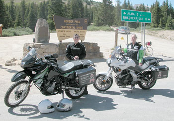
I was sure the road to Boreas Pass ran off CO 9 from a little north of Breckenridge toward the pass but I followed Sue on up to the top of Hoosier Pass, where we pulled off. “Oh yeah, Hoosier Pass, that’s the name,” she said as we dismounted. So no, I didn’t get to do Boreas Pass. Turns out the Versys I was on didn’t have the right tires for dirt anyway.

So we admired the view, chatted with another biker who pulled off there, and then headed back down the pass, up I-70 to Copper Mountain, and then rode to the top of Fremont Pass. Then we headed back to Keystone.

I didn’t get to ride dirt but I did get a chance to ride the Versys, which was a new one for me. It feels a lot different from the inline fours I’m accustomed to but I definitely liked the upright seating position. I was interested to find that the little half windshield did a very good job of blocking the wind blast at speed. I’ve never enjoyed riding without a fairing or windshield for that reason.

The seat was much too hard for me to even imagine taking off for a weeklong ride as we do each summer. Other than that, it was a nice bike. I’d really like to do more off-pavement riding because there is so much of it here in Colorado and I really feel like I’m missing a lot. I don’t have room for a third bike, though, so maybe it’s something to consider whenever one of my current two dies. But that’s not likely to happen soon. There must be another way to work this out.

Anyway, it was fun getting to ride the bike and Sue is a fun person to hang out with. And I’ll have a chance to get some dual-sport riding instruction before the Adventure for the Cures ride sets off. Of course I’ll be reporting back to you on that.

Recent from the National Motorcycle Examiner
Dual-sport motorcyclists combat cancer

Biker Quote for Today

You never see a motorcycle parked in front of a psychiatrist’s office.

17 Passes in 32 Hours

Monday, July 13th, 2009

Steve Smith had asked my assistance in planning his Colorado ride and he sent me this follow-up now that he’s back home. He rode some passes I’ve never been on. Makes it especially interesting. Here’s Steve’s report.

***************************************************

My trip started in the western North Carolina mountains on Friday, July 3. My dog and I made Oklahoma City that night thru some nice hot weather. Saturday, the 4th, we kept on to New Mexico and up thru Taos to Antonito, Colorado area. I was not sure just exactly where some of the campgrounds were located on your website, so I took the safe route and checked AAA where I found the camp ground at Mogote. The people were nice and had a free cook out that evening. The facilities were nice with a shower and nice shaded camping area for $18.

sport bikes
  Stunner Pass

The next morning I rode past the camp grounds that you mentioned and they looked very nice. My goal was to ride to the pass and find a sign and get a picture, so my first pass that morning was La Manga. It was a nice ride over to Cumbres for my second pass in just 30 minutes or so. I retraced my tracks back across La Manga to the forest road 250 and up to Stunner Pass. This road was very navigable but not recommended for a shiny Harley or Goldwing, due to the rocks and potholes. I was riding a loaded 1150 GS and it was slow going in a few places. As with all the roads in Colorado, they are all very scenic with great vistas. I kept going north up to the highway and made a left turn to Wolf Creek Pass for my 4th pass that day.

The next two passes were easy to achieve on a great road up thru Creede and on to Spring Creek Pass and then Slumgullion Pass for the 5th and 6th passes. Just past Slumgullion towards Lake City I made a right turn towards Los Pinos Pass. This road was even rougher than the road to Stunner but still was very scenic. At this pass the sign had disappeared so I have no picture of that one.

Once thru the pass it was about 29 miles out to Hwy 114 and to North Pass for my 8th pass. A u-turn took me back to Gunnison where I went up thru Crested Butte and on towards Kebler Pass. Before I got to that one there was a road off to the left to Ohio Pass. I found no sign but a nice rocky, pot-holed road for a couple of miles. Kebler was my 10th pass that day and the road on out to Paonia was a very nice gravel road. The aspen surrounding the Lupines and was a sight to behold. That evening I camped at the Redstone campground for $32. Yes I went over McClure Pass but since it was under 10,000 ft, I didn’t count it for that day.

By the end of the day I had ridden over 10 passes above 10,000 feet and was done with the pass counting in 10 hours.

sport bikes
  Los Pinos Road

The next morning, I left Redstone and ventured up thru the slow traffic at Aspen to Independence Pass. Wow, the views were great. My next pass was Tennessee Pass north of Leadville. I retraced my track back to Leadville for lunch and then up to Fremont Pass. I continued north to I-70 over Vail Pass and then on to Shrine Pass, just a short 3 miles from the rest area on a good hard packed road that any bike could handle.

Next in my sights was Loveland Pass and then to Guanella Pass south of Georgetown, but the road was closed for construction so I went to Berthoud Pass instead. That was my last pass, as I told my sister I would be at her house north of Woodland Park at 4 PM. The road down thru Deckers was very nice and I was able to beat or avoid some rain and hail.

My total account was 17 passes over 10,000 ft. I started around 8 AM on July 5th and was drinking a cool one by 4 PM the next afternoon or 32 hours total. In hindsight I could have done more if I wasn’t so packed down and left my dog at home, but we had an excellent ride thru some very beautiful country.

I would not recommend Stunner and Los Pinos Passes for an inexperienced rider. That may be done better in a car or truck. On the other hand, any bike could make it, but it may be missing some parts that get rattled off during the ride.

***************************************************

OK, so thank you Steve for that ride description. Now I’m going to have to find out where Stunner and Los Pinos Passes are.

Recent from the National Motorcycle Examiner
Could there be an Eco Mobile in your future?

Biker Quote for Today

If it can’t do some dirt, why bother?

Three Days on the Bike, an Exploration

Saturday, July 11th, 2009

Just got in last night from a three-day ride through western Colorado. Never had one heart-pounding moment but I sure had to deal with heat and dehydration. And I paid for trying to walk somewhere in my motorcycle boots.

Keep your bike in good repair: Motorcycle boots are NOT comfortable for walking.

There are so many times I have gone west on I-70 out of Denver and looked longingly at the remnants of the old highway, U.S. 6, that you see in places, wishing I was out of the traffic and over on that nice, twisty piece of two-lane. So I decided to do it. I wanted to see just how much of Colorado’s mountains you could cross on the old highway.

And the answer is, quite a bit. I’ll save the details for another time but it was really nice to cruise along at an easy pace and not have to deal with the interstate traffic. The times when I did have to get on the superslab it was truly unpleasant feeling the need to ride faster and deal with all this even faster traffic whizzing by me. Returning to the two-lane was always a joy.

sport bikes
  A portion of the artwork

Reaching Glenwood Canyon, I knew there were some remnants of the old road accessible from the exits. This canyon is so narrow, however, that they could barely get the interstate in there, much less preserve the old route. There is, however, a good-sized chunk of the old road that you get to off the No Name exit, near the west end of the canyon. There the road curves down alongside the river, but there is a barricade that now blocks motorized vehicles. You can walk or ride your bicycle down there, but no motorcycle.

The road went on around a bend and out of sight, and I wanted to walk down there, but I didn’t want to do that in my heavy boots. So I figured I’d walk just far enough to get a better camera angle. Along the way I met some folks coming back and they told me of an area with picnic tables, a sandy beach, and some clever natural-materials artwork that “some hippie probably smoked a joint and spent the whole day constructing.” Now I was interested.

The fellow told me it was about half a mile down (too far in boots!) but then he also mentioned it in terms of “about 10 minutes.” Ooh, I thought, I can walk 10 minutes in these boots, and 10 back. So off I went.

To make a long story short, I found the art, and it was indeed worth checking out. It’s the sort of thing that a photograph generally does not do justice to, but I’m including two detail shots that give a bit of the idea. Nothing at all like the real thing, unfortunately.

sport bikes
  Another detail

Then it was time to head back. And I hadn’t gone far and I could feel a blister forming on my left heel. Pretty soon I knew it was going to be a very unpleasant walk unless I could do something about the blister. I had a notebook with me so I tore out a sheet, folded it, and stuck it inside my sock where the blister was. It was amazing. I could now walk without any discomfort at all.

About the time I was 40 feet from the bike, however, the sweat-soaked paper was no longer offering protection and another blister was forming on my right heel. I gritted it out and was really happy to get back on the bike. Then I stopped at the first place I could find in Glenwood Springs and bought Band-Aids and switched to my sneakers. The moral, don’t ever try to walk far in motorcycle boots.

Recent from the National Motorcycle Examiner
Sportbikers and ABATE: Can the twain meet?

Biker Quote for Today

The road is only open when you ride alone.

Texas Rode the Rockies

Monday, July 6th, 2009

Ray from Texas did the ride I helped him map out and is back home again. He sent me a note to when he got home:

Thanks to some great advice on the routes and sights to stop, I had a
wonderful ride! FANTASTIC! Would go again in a heart-beat!

He also sent along a slide show of the ride, so we can all enjoy some of the great riding he did. A picture is worth a thousand words and there are more than 100 pictures here. Be aware that this is a fairly large file and may take a minute or so to open.

Colorado Trip on a R1200GS Adventure

Thanks Ray.

Recent from National Motorcycle Examiner
Motorcycle noise testing simplified, but will governments hear?

Biker Quote for Today

Two-lane blacktop isn’t a highway – it’s an attitude.

Texas Rides The Rockies

Monday, June 29th, 2009

Texas rides the Rockies map

I’m frequently asked to help people plan their routes when they’re coming to Colorado to ride, and I’m always happy to oblige.

Last year I posted a series I called “New Zealand Rides The Rockies” where I laid out the day by day rides of a group on New Zealanders planning to come here this year. Unfortunately, the world economic meltdown derailed their plans, at least for now.

However, if you don’t have to fly halfway around the world and you don’t have to rent motorcycles, coming to Colorado to ride is actually one of the less expensive vacations you can take. I can confirm that a good number of people are doing just that.

Among them are Ray and some of his friends from Texas, who are cruising around Colorado right this moment, presuming they didn’t have any last minute glitches. I’m not going to lay this out in the detail I did for the Kiwis but I figured you might have some interest in their plans.

Days One and Two

Ray and friends are coming from the Dallas-Ft. Worth area (I believe) and were riding to Las Vegas, NM, the first night. From there, on Day Two, they were planning to head north to Taos and on up to where they would reach U.S. 160 at Fort Garland. They planned on taking U.S. 160 west to South Fork, then CO 149 over Slumgullion Pass to Lake City, and then the gravel roads over to just south of Ouray. Ridgway was their destination for the night.

These plans were revised considerably when I pointed out to Ray that it would be a much nicer ride to take U.S. 64 west from just north of Taos, via Chama, and then U.S. 84 up to Pagosa Springs. From Pagosa, a run over Wolf Creek Pass would put them at South Fork. I also mentioned that they must be riding dual sport bikes if they were planning on taking that road west out of Lake City.

Apparently they aren’t, so that road was nixed. Instead, they adopted my suggestion of the Chama route and then just continued on through Lake City to Gunnison for the night.

Day Three

Day Three was to be a fairly easy one after a long Day Two. Heading west out of Gunnison they planned to stop at Black Canyon of the Gunnison National Park and ride the South Rim Drive and the East Portal Road. Then they would make the easy cruise to Ouray and make that their headquarters for two nights.

Day Four

Day Four is planned as a circle route through Ridgway, Placerville, Telluride, Cortez, Durango, Silverton, and back to Ouray. This will take them over Lizard Head Pass and Red Mountain Pass. Red Mountain Pass, of course, is one of the best in the state.

Day Five

On Day Five, Ray and friends are heading north through Montrose and Delta and will then head northeast on CO 92 to Hotchkiss and up and over McClure Pass on CO 133. At Carbondale they will turn southeast on CO 82 through Aspen and over Independence Pass, another of Colorado’s very best.

A run through Leadville and then down Fremont Pass to Copper Mountain will put them at I-70, where they will head east to Silverthorne. They’ll take U.S. 6 up over Loveland Pass and end up for the night in Idaho Springs.

Day Six

From Idaho Springs our travelers will head south on CO 103 up Squaw Pass with a sidetrip to the top of Mount Evans. From the Bergen Park area they’ll head south to Evergreen and on to Conifer where they’ll pick up U.S. 285 for just a short jaunt. At Pine Junction they’ll head south on CO 126 through Deckers and on to Woodland Park and Colorado Springs.

Days Seven and Eight

In the morning of Day Seven, Ray and the rest will make a run up to the top of Pikes Peak, then head back down and blast homeward as far as Amarillo. Day Eight will see them home again in the Dallas area.

Recent from National Motorcycle Examiner
10th Annual V2V: Victory riders ride Victory Highway

Biker Quote for Today

Fun is not a straight line.

Bikertv.ca Gives a Taste of Canadian Motorcycling

Monday, June 22nd, 2009

How hard must it be to be a motorcyclist in Canada? I mean, almost the entire country is north of North Dakota, so their riding season has got to be way too short.

BikerTV logoOn the other hand, when they can ride, how incredible must the riding be? There’s the Canadian Rockies and British Columbia. I’ve been there and it’s gorgeous. Then there are the Eastern Seaboard provinces, and everything I’ve read says they’ve got some great riding, too. Quebec and Ontario are also gorgeous.

In other words, Canadians do ride, and in fact, they even have their own television show, BikerTV. It shows on Canadian TV but it is also available on the web. They have a couple young ladies who emcee the thing, and they’re not terribly convincing as in-the-know biker types. They’re more eye candy. But the stories cover a wide range of topics and follow Canadian bikers doing some rides I’d sure like to do.

The show is in its fifth season and they have more online viewers than broadcast viewers: 70,000 vs. 51,000.

It’s worth a look. Who knows, maybe your next trip will be to Canada.

Recent from National Motorcycle Examiner
Motorcycle control in high winds

Biker Quote for Today

Don’t choose a destination — pick a direction and go.

Some Great Motorcycle Roads in Southwestern Utah

Monday, June 8th, 2009

When we get out of Colorado, one of our favorite places to ride is Utah. Judy and I spent the last week in southwestern Utah, and although we were there in the car, not on the bike, I spent a good bit of time while we were there scoping the place out for next year’s OFMC ride. Here’s a quick recap of what I’ll be pitching to the guys to convince them this is the trip we want to make. And here’s a map showing the roads we took. Unfortunately, the mapping software doesn’t show the actual roads in some instances due to the degree of zoom, but I’ll try to be sufficiently specific.

map of southwestern UtahFirst off, we blasted out on the interstate to the ski area of Brian Head. This was about 650 miles, which is one of the reasons we didn’t go on the bike. We are definitely not iron butt candidates. We got off I-15 at Parowan and took Utah 148 to Brian Head. It was a nice ride up a canyon, and steep. Up at the town they have a sign telling folks heading down that it’s a 13% grade for the next 10 miles. Of course that spells fun on a motorcycle.

Utah 148 runs on south from Brian Head through Cedar Breaks National Monument. We had never been there before and it was gorgeous. High cliffs looking down on sculpted red canyons. Numerous scenic overlooks. Very nice. Highway 148 connects a little south of Cedar Breaks with Utah 14. We took it first to the west, to Cedar City. More gorgeous canyons and incredible panoramic views. Highly recommended.

On our second full day we again headed south on Utah 148 but quickly turned off heading east on Utah 143. This goes to the very nice small town of Panguitch, and from there we turned south on U.S. 89 just a few miles to Utah 12. This road very quickly comes into Red Canyon and it’s a stunning sight. It portends what you’re going to see further up the road in Bryce Canyon, Red Canyon is fabulous in its own right.

Another 10 miles or so down the road you do run into the road that goes south into Bryce Canyon. This is Utah 63. You have to pay to get into the park, $12 per person for motorcycles, but it’s worth it. Take the road all the way to the end, at Rainbow Point, and then stop at the turnouts and scenic viewpoints on your way back up. They’re all on your right that way, and that’s a lot easier than constantly turning across traffic.

After Bryce we continued on Utah 12 down to Cannonville, where we turned off on Cottonwood Road and headed down to Kodachrome Basin State Park. This is nowhere near as spectacular as Bryce Canyon but it’s a nice side trip if you have the time. The road is paved all the way in.

We rested our tired feet for a day (we did a lot of hiking) and then headed out on a two-day tour of Zion National Park. Back down Utah 148 to Utah 14 to Cedar City, and then south on I-15, until we came to the turn-off for Zion National Park-Kolob Canyons. This is just a short jump off the interstate, about five miles to the end, and you get a spectacular view of a different part of the park than most people see. I never knew it was here. Admission is the same as at Bryce.

Then back on the interstate, down to Utah 17, to La Verkin, where we got on Utah 9. Arriving at Virgin, there was no sign for Zion but Judy had done her research and knew that if we turned off on Kolob Road it would take us up into the park. This was absolutely the highlight of our trip. This road is sensational! It’s a gorgeous ride and the views are the best you’re going to see in this park. And almost no one knows it exists. Well, now you do, so don’t miss out on it if you’re down this way. It’s incredible.

Back on Utah 9, we came to the south entrance to Zion and this is touristville. Springdale has turned into a little Aspen since the last time I was there and you can no longer drive up Zion Canyon, except during the off season. They run frequent shuttle buses and that’s the only way to go. I was not thrilled with the idea at first but when I saw how much nicer it was than the incredible congestion I remember I decided it was OK. But really, I could just about skip this part of the park. It’s nice and all, but I’ve been there a number of times and it doesn’t thrill me any more.

Heading on out of that part of the park you then climb a terrific series of switch-backs and then cross through a long tunnel with numerous windows, opening in the rock walls, until you get outside of the canyon. There is a parking lot right at the east end of the tunnel and a trail that leads back over the hump to give you an incredible view of where you just came from. I strongly recommend this hike. It’s not far and it’s well worth it.

On out of the park on Utah 9 and then north on U.S. 89, until we reached Utah 14 at its east end, and then back to Utah 148 and home to Brian Head. Very scenic the entire way. We loved it. We’ll be back. And I’m hoping the OFMC will be heading that way next year. I do have an ace in the hole with the guys: Mesquite, NV, is just down the road from here about 45 miles and they love to gamble. Utah here we come.

Recent from the National Motorcycle Examiner
ABATE sponsors racer in outreach to sportbikers

Biker Quote for Today

Sometimes you end up going down the wrong road. That’s an adventure.

Independence Pass, Mount Evans Now Open; Loveland Pass Closed

Thursday, May 21st, 2009

Independence PassNote to the world: Colorado is open for the season.

That’s right, with today’s opening of Independence Pass and CO 5 to the top of Mount Evans opening tomorrow, all the seasonal roads are open. Even Trail Ridge Road is open, although the Colorado Department of Transportation (CDOT) reports that it is icy in spots.

One note of interest, however, is that US 6 over Loveland Pass is closed at this time. This is not a seasonal road, but CDOT says it is “closed for emergency road repair until further notice.” Apparently they just closed it yesterday. That’s a good thing for me to know because I was planning to head up over that pass in just a couple days.

Here’s a bit more info from CDOT:

U.S. 6 over Loveland Pass is closed due to a culvert failure, about 1 ½ miles east of the summit. Excess water has washed out the bottom of the culvert. Safety considerations will not allow the road to be open to traffic due to a loss of roadway support over the culvert. All traffic will be detoured though the Eisenhower Tunnel on Interstate 70. Loveland Pass will remain closed until further notice. The Colorado Department of Transportation will send out more information when it becomes available.

Recent from Denver Motorcycle Examiner
Run For The Wall nearing its destination

Biker Quote for Today

If you don’t make it the first time, back up and try again, only faster!!